
Lower Allen Township is a township in Cumberland County, Pennsylvania, United States. The population was 17,980 at the 2010 census.

Bala Cynwyd is a community in Lower Merion Township, Pennsylvania, United States. It is located on the Philadelphia Main Line in Southeastern Pennsylvania and borders the western edge of Philadelphia at U.S. Route 1. The present-day community was originally two separate towns, Bala and Cynwyd, but was united as a singular community largely because the U.S. Post Office, the Bala Cynwyd branch, served both towns using ZIP Code 19004. The community was long known as hyphenated Bala-Cynwyd. Bala and Cynwyd are currently served by separate stations on SEPTA's Cynwyd Line of Regional Rail.

Miaoli County is a county in western Taiwan. Miaoli is adjacent with Hsinchu County and Hsinchu City to the north, Taichung to the south, and borders the Taiwan Strait to the west. Miaoli is classified as a county in central Taiwan by the National Development Council, while the Taiwan Central Weather Bureau classifies Miaoli as a county in northern Taiwan. Miaoli City is the capital of the county, and is also known as "Mountain Town", owing to the number of mountains nearby, making it a destination for hiking.

Allendale, often marked on maps as Allendale Town, is a village and civil parish in south west Northumberland, England. It is located within the North Pennines Area of Outstanding Natural Beauty.

Tiny, also known as Tiny Township, is a township in Simcoe County, south-central Ontario, Canada. The Township of Tiny can be found in the southern Georgian Bay region and is approximately 30 kilometres (19 mi) long or 410 square kilometres (160 sq mi).
Fall River is a suburban community located in Nova Scotia, Canada within the Halifax Regional Municipality. It is located north-northeast of the Bedford Basin, northeast of Bedford and Lower Sackville and north of Waverley.

Unionville is a suburban district and former village in Markham, Ontario, Canada, 2 km (2.5 mi) west of Markham Village, and 33 km (20.5 mi) northeast of Downtown Toronto. The boundaries of Unionville are not well-defined. Several neighbourhoods claim to be part of it however, this has been disputed between the various wards.

Edwardsburgh/Cardinal is a township in the United Counties of Leeds and Grenville of eastern Ontario, Canada. Edwardsburgh township was first surveyed in 1783, and incorporated in 1850. The township was part of the historical Grenville County before it merged with Leeds County to form the United Counties in the 19th century.

Laško is a spa town in eastern Slovenia. It is the seat of the Municipality of Laško. The area is part of the traditional region of Styria. The municipality is now included in the Savinja Statistical Region. The town is located at the foothills of Hum Hill on the Savinja River. It was first mentioned in written documents dating to 1227 and was granted town privileges in 1927. It is known to have been settled since the Iron Age and Roman archaeological finds are common in the area, though the precise location of the Roman settlement is not known. Today the town is best known for its annual Festival of Beer & Flowers and the local Laško Brewery, the largest brewery in the country. In 2010, Laško was heavily affected by flooding. The town's coat of arms depicts three white fleurs-de-lis on a blue field.

Alcúdia (Catalan pronunciation:[əlˈkuðiə]) is a municipality and township of the Spanish autonomous community of the Balearic Islands. It is the main tourist centre in the North of Majorca on the eastern coast. It is a large resort popular with tourists. Most of the hotels are located in Port d'Alcúdia and Platja d'Alcúdia, along the 14 km-long (8.7 mi) beach that stretches all the way to Ca'n Picafort. In Alcúdia, the old town is well preserved with houses dating back to the 13th century. The old town is surrounded by a medieval wall.

Annahilt / Anahilt is a village and civil parish in north County Down, Northern Ireland. It is 7.5 miles south of Lisburn, and about 14 miles south-west of Belfast, on the main road between Ballynahinch and Hillsborough. In the 2001 Census the village had a population of 1,148. Annahilt has a distinctive drumlin setting, with a small wooded estate on a ridge to the west, and panoramic views on the approaches to the village.

Ballycarry is a village in County Antrim, Northern Ireland. It is midway between Larne and Carrickfergus, overlooking Islandmagee, and is part of the Mid and East Antrim Borough Council area. In the 2001 Census it had a population of 981.
Milltown is a small settlement in County Antrim, Northern Ireland. It is within the townland of Derriaghy, about one mile to the north of Lisburn. Once a rural village, it is now part of Greater Belfast. However, it is separated from the surrounding urban area by a narrow stretch of countryside. It had a population of 1,499 people in the 2011 Census.
Lambeg is a small village and civil parish in County Antrim, Northern Ireland. Located between Belfast and Lisburn, it was once a small rural village, but is now within the Greater Belfast conurbation. Lambeg is also an electoral ward of Lisburn Council. In the 2001 Census it had a population of 60 people. The civil parish of Lambeg covers areas of County Down as well as County Antrim.

Dunmurry is a suburban town and townland near Belfast, Northern Ireland. Dunmurry is in the Collin electoral ward for the local government district of Belfast City Council.
Scenery Hill, which was known as Hillsborough prior to April 10, 1867, is an unincorporated community which is located in North Bethlehem Township in Washington County, Pennsylvania, United States. It serves as the postal address for most North Bethlehem Township residents. The ZIP code is 15360.
Táp is a village in Győr-Moson-Sopron county, Hungary.

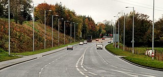
Pennsylvania Route 114 is a 19-mile-long (31 km) state highway located in Cumberland and York counties in Pennsylvania. The western terminus is at PA 944 in Wertzville. The eastern terminus is at State Route 1003 adjacent to the Capital City Airport near New Market. PA 114 heads south from PA 944 through the western suburbs of Harrisburg and has an interchange with Interstate 81 (I-81) before it comes to an intersection with U.S. Route 11 in Hogestown. The route continues south to Mechanicsburg, where it forms a concurrency with PA 641. From here, PA 114 heads south to an interchange with US 15 and turns east in Bowmansdale, continuing to Lisburn. The route leaves Cumberland County for York County and reaches a junction with PA 382, where it turns north through rural areas and intersects PA 262. PA 114 curves northeast and comes to an interchange with I-83 before it continues to its terminus.

Lawndale is a neighborhood in Northeast Philadelphia, Pennsylvania, United States. It is located near Rising Sun and Oxford avenues and is south of Cottman Avenue.
Pentre Broughton is a formerly industrial village in the community of Broughton in Wrexham County Borough, Wales. It is contiguous with the neighbouring villages of Moss and Brynteg.
