Forks Township, Northampton County, Pennsylvania

Last updated

Forks Township
Forks Township, Northampton County, PA, USA.jpg
Forks Township's welcome sign in November 2020
Forks Township Seal.png
Map of Forks Township, Northampton County, Pennsylvania Highlighted.png
Location of Forks Township in Northampton County, Pennsylvania
Pennsylvania in United States (US48).svg
Location of Forks Township in Pennsylvania in the United States
Coordinates: 40°45′06″N75°13′59″W / 40.75167°N 75.23306°W / 40.75167; -75.23306
Country Flag of the United States.svg  United States
State Flag of Pennsylvania.svg  Pennsylvania
County Northampton
Founded1754
Area
[1]
  City12.27 sq mi (31.79 km2)
  Land12.11 sq mi (31.35 km2)
  Water0.17 sq mi (0.43 km2)
Elevation
377 ft (115 m)
Population
 (2010)
  City14,721
  Estimate 
(2016) [2]
15,417
  Density1,273.61/sq mi (491.75/km2)
   Metro
865,310 (US: 68th)
Time zone UTC-5 (EST)
  Summer (DST) UTC-4 (EDT)
Area code(s) 610
FIPS code 42-095-26728
Primary airport Lehigh Valley International Airport
Major hospital Lehigh Valley Hospital–Cedar Crest
School district Easton Area
Website www.forkstownship.org

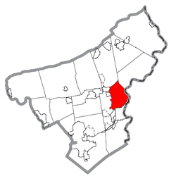
Forks Township is a township in Northampton County, Pennsylvania, United States. The population of Forks Township was 14,721 as of the 2010 census. It is part of the Lehigh Valley metropolitan area, which had a population of 861,899 and was the 68th-most populous metropolitan area in the U.S. as of the 2020 census. The township is home to the global headquarters of Crayola, founded in 1885, a global arts supply company and the world's leading manufacturer of crayons.

Contents

Forks Township is located 20.8 miles (33.5 km) northeast of Allentown, 80.5 miles (129.6 km) north of Philadelphia, and 74.6 miles (120.1 km) west of New York City.

Geography

PA Route 611 North in Forks Township 2022-09-27 14 44 33 View north along Pennsylvania State Route 611 (Delaware Drive) just north of Danser Hill Road in Forks Township, Northampton County, Pennsylvania.jpg
PA Route 611 North in Forks Township

According to the U.S. Census Bureau, the township has a total area of 12.2 square miles (32 km2), of which 12.1 square miles (31 km2) is land and 0.2 square miles (0.52 km2) (1.39%) is water. It is drained by the Delaware River, which separates it from New Jersey. Its six villages are Chestnut Hill, Churchville, Keplers Mill, Sandts Eddy, Uhlers Station, and Zucksville. The township was named Forks since it lies at the "fork" of two rivers in the region, the Delaware and Lehigh.

Neighboring municipalities

Transportation

As of 2015, there were 88.35 miles (142.19 km) of public roads in Forks Township, of which 23.78 miles (38.27 km) were maintained by the Pennsylvania Department of Transportation (PennDOT) and 64.57 miles (103.92 km) were maintained by the township. [3]

Pennsylvania Route 611 is the only numbered highway traversing Forks Township. It runs north-to-south through the township along the Delaware River. Other local roads of note include Bushkill Drive, Frost Hollow Road, Kesslersville Road, Knox Avenue/Sullivan Trail, Newlins Road, Richmond Road, Uhler Road, and Zucksville Road.

Demographics

Historical population
CensusPop.Note
1990 5,969
2000 8,41941.0%
2010 14,72174.9%
2016 (est.)15,417 [2] 4.7%
U.S. Decennial Census [4]

At the 2000 census there were 8,419 people, 3,035 households, and 2,415 families living in the township. The population density was 698.2 inhabitants per square mile (269.6/km2). There were 3,159 housing units at an average density of 262.0 per square mile (101.2/km2). The racial makeup of the township was 94.92% White, 2.24% African American, 0.05% Native American, 1.39% Asian, 0.01% Pacific Islander, 0.62% from other races, and 0.77% from two or more races. Hispanic or Latino of any race were 2.05%. [5]

There were 3,035 households, 39.8% had children under the age of 18 living with them, 70.7% were married couples living together, 6.3% had a female householder with no husband present, and 20.4% were non-families. 17.0% of households were made up of individuals, and 6.8% were one person aged 65 or older. The average household size was 2.76 and the average family size was 3.13. The age distribution was 27.6% under the age of 18, 4.3% from 18 to 24, 31.3% from 25 to 44, 24.1% from 45 to 64, and 12.7% 65 or older. The median age was 39 years. For every 100 females, there were 95.7 males. For every 100 females age 18 and over, there were 94.1 males. The median household income was $66,055 and the median family income was $70,587. Males had a median income of $51,965 versus $30,661 for females. The per capita income for the township was $26,180. About 2.7% of families and 3.0% of the population were below the poverty line, including 2.7% of those under age 18 and 6.0% of those age 65 or over.

History

Forks Township was founded in 1754 north of The City of Easton, Pennsylvania. It was founded as a farming based community in-between the Bushkill Creek and Delaware River. Prior to the Walking Purchase of 1737 the Lenni-Lenape natives were inhibiting the area. Many artifacts were found in the area.

Permanent settlement by the colonists happened in the early 1700s due to its proximity to the Irish-Scottish settlement named "Hunter's Settlement" in Lower Mount Bethel Township. After decades of new settlers settling in the Lehigh Valley, Northampton County, PA was formed from Bucks County, PA in the south. Many taverns and inns were developed due due major roads that were built throughout the area such as PA Route 611 in the 1800s.

During the Industrial Revolution many dairy industries and blacksmiths was the economy to the area. Crayola was founded in 1903 as a small crayon industry in Easton and had moved its headquarters to Forks Township. But in the mid 1900s, the decrease of agriculture ped to major suburban development in the area. Since the 1990s, the area has converted to a mostly suburban development to Easton. [6]

Education

The township is served by the Easton Area School District, and is home to three of the school district's schools: Shawnee Elementary, Forks Elementary, and Easton Area Middle School for grades five through eight. Students in grades nine through 12 attend Easton Area High School in Easton.

Related Research Articles

<span class="mw-page-title-main">Riegelsville, Pennsylvania</span> Borough in Pennsylvania, United States

Riegelsville is a borough in Bucks County, Pennsylvania, United States. The population was 868 at the 2010 census. It is included in the Philadelphia–Wilmington–Camden metropolitan statistical area, despite being so closely connected to the Lehigh Valley.

<span class="mw-page-title-main">Hanover Township, Lehigh County, Pennsylvania</span> Township in Pennsylvania, United States

Hanover Township is a township in Lehigh County, Pennsylvania, United States. As of the 2010 census, the township had a population of 1,571. It is a suburb of Allentown and Bethlehem and part of the Lehigh Valley metropolitan area, which had a population of 861,899 and was the 68th-most populous metropolitan area in the U.S. as of the 2020 census.

<span class="mw-page-title-main">North Whitehall Township, Pennsylvania</span> Township in Pennsylvania, United States

North Whitehall Township is a township in Lehigh County, Pennsylvania, United States. The population of North Whitehall Township was 15,655 at the 2020 census. It is a suburb of Allentown in the Lehigh Valley, which had a population of 861,899 and was the 68th-most populous metropolitan area in the U.S. as of the 2020 census.

<span class="mw-page-title-main">Upper Macungie Township, Pennsylvania</span> Township in Pennsylvania, United States

Upper Macungie Township is a township in Lehigh County, Pennsylvania, United States. The population of Upper Macungie Township was 26,377 as of the 2020 U.S. census, making it the fourth-fastest growing municipality of any category in Pennsylvania in terms of total population growth between 2010 and 2020.

<span class="mw-page-title-main">Upper Saucon Township, Pennsylvania</span> Township in Pennsylvania, United States

Upper Saucon Township is a township in Lehigh County, Pennsylvania, United States. It is part of the Lehigh Valley metropolitan area, which had a population of 861,899 and was the 68th-most populous metropolitan area in the U.S. as of the 2020 census. The township had a population of 16,973 as of the 2020 census.

<span class="mw-page-title-main">Allen Township, Northampton County, Pennsylvania</span> Township in Pennsylvania, United States

Allen Township is a township in Northampton County, Pennsylvania, United States. The population of Allen Township was 4,269 at the 2010 census. Allen Township is part of the Lehigh Valley metropolitan area, which had a population of 861,899 and was the 68th-most populous metropolitan area in the U.S. as of the 2020 census.

<span class="mw-page-title-main">Bethlehem Township, Pennsylvania</span> Place in Pennsylvania, United States

Bethlehem Township is a township in Northampton County, Pennsylvania, United States. The population of Bethlehem Township was 23,730 at the 2010 census. It is a suburb of Bethlehem and is part of the Lehigh Valley metropolitan statistical area, which had a population of 861,899 and was the 68th-most populous metropolitan area in the U.S. as of the 2020 census.

<span class="mw-page-title-main">Bushkill Township, Pennsylvania</span> Township in Pennsylvania, United States

Bushkill Township is a township in Northampton County, Pennsylvania, United States. Its population was 8,178 at the 2010 census. It is part of the Lehigh Valley metropolitan area, which had a population of 861,899 and was the 68th-most populous metropolitan area in the U.S. as of the 2020 census.

<span class="mw-page-title-main">Easton, Pennsylvania</span> City in Pennsylvania, United States

Easton is a city in, and the county seat of, Northampton County, Pennsylvania, United States. The city's population was 28,127 as of the 2020 census. Easton is located at the confluence of the Lehigh River, a 109-mile-long (175 km) river that joins the Delaware River in Easton and serves as the city's eastern geographic boundary with Phillipsburg, New Jersey.

<span class="mw-page-title-main">Hanover Township, Northampton County, Pennsylvania</span> Place in Pennsylvania, United States

Hanover Township is a township in Northampton County, Pennsylvania, United States. The population of Hanover Township was 10,866 at the 2010 census.

<span class="mw-page-title-main">Lehigh Township, Northampton County, Pennsylvania</span> Place in Pennsylvania, United States

Lehigh Township is a township in Northampton County, Pennsylvania, United States. The population of Lehigh Township was 10,526 as of the 2010 census. It is part of the Lehigh Valley metropolitan area, which had a population of 861,899 and was the 68th-most populous metropolitan area in the U.S. as of the 2020 census.

<span class="mw-page-title-main">Lower Mount Bethel Township, Pennsylvania</span> Place in Pennsylvania, United States

Lower Mount Bethel Township is a township in Northampton County, Pennsylvania, United States. The population of Lower Mount Bethel Township was 3,101 at the 2010 census. Lower Mount Bethel Township is part of the Lehigh Valley metropolitan area, which had a population of 861,899 and was the 68th-most populous metropolitan area in the U.S. as of the 2020 census.

<span class="mw-page-title-main">Lower Nazareth Township, Pennsylvania</span> Place in Pennsylvania, United States

Lower Nazareth Township is a township in Northampton County, Pennsylvania, United States. The population of Lower Nazareth Township was 5,674 at the 2010 census. The township is located in the Lehigh Valley, which had a population of 861,899 and was the 68th-most populous metropolitan area in the U.S. as of the 2020 census.

<span class="mw-page-title-main">Moore Township, Pennsylvania</span> Place in Pennsylvania, United States

Moore Township is a township in Northampton County, Pennsylvania, United States. The population of Moore Township was 9,198 at the 2010 census. The township is located in the Lehigh Valley, which had a population of 861,899 and was the 68th-most populous metropolitan area in the U.S. as of the 2020 census.

<span class="mw-page-title-main">Palmer Township, Pennsylvania</span> Second Class Township in Pennsylvania, United States

Palmer Township is a township in Northampton County, Pennsylvania, United States. The population of Palmer Township was 22,317 at the 2020 census. It is the eight-largest municipality in the Lehigh Valley metropolitan area, which had a population of 861,899 and was the 68th-most populous metropolitan area in the U.S. as of the 2020 census.

<span class="mw-page-title-main">Plainfield Township, Pennsylvania</span> Place in Pennsylvania, United States

Plainfield Township is a township in Northampton County, Pennsylvania, United States. The population of Plainfield Township was 6,138 at the 2010 census. The township is part of the Lehigh Valley metropolitan area, which had a population of 861,899 and was the 68th-most populous metropolitan area in the U.S. as of the 2020 census.

<span class="mw-page-title-main">Stockertown, Pennsylvania</span> Place in Pennsylvania, United States

Stockertown is a borough in Northampton County, Pennsylvania. The borough's population was 927 as of the 2010 census. It is part of the Lehigh Valley metropolitan area, which had a population of 861,899 and was the 68th-most populous metropolitan area in the U.S. as of the 2010 census.

<span class="mw-page-title-main">Upper Mount Bethel Township, Pennsylvania</span> Place in Pennsylvania, United States

Upper Mount Bethel Township is a township in Northampton County, Pennsylvania, United States. The population of Upper Mount Bethel Township was 6,706 at the 2010 census. The township is part of the Lehigh Valley metropolitan area, which had a population of 861,899 and was the 68th-most populous metropolitan area in the U.S. as of the 2020 census.

<span class="mw-page-title-main">Upper Nazareth Township, Pennsylvania</span> Place in Pennsylvania, United States

Upper Nazareth Township is a township in Northampton County, Pennsylvania, United States. It is part of the Lehigh Valley metropolitan area, which had a population of 861,899 and was the 68th-most populous metropolitan area in the U.S. as of the 2020 census. At the 2010 census, Upper Nazareth Township's population was 6,231.

<span class="mw-page-title-main">Williams Township, Northampton County, Pennsylvania</span> Township in Pennsylvania, United States

Williams Township is a township in Northampton County, Pennsylvania, United States. The township's population was 6,581 at the 2020 census. The township is part of the Lehigh Valley metropolitan area, which had a population of 861,899 and was the 68th-most populous metropolitan area in the U.S. as of the 2020 census.

References

  1. "2016 U.S. Gazetteer Files". United States Census Bureau. Retrieved August 14, 2017.
  2. 1 2 "Population and Housing Unit Estimates" . Retrieved June 9, 2017.
  3. "Forks Township map" (PDF). PennDOT. Retrieved March 16, 2023.
  4. "Census of Population and Housing". Census.gov. Retrieved June 4, 2016.
  5. "U.S. Census website". United States Census Bureau . Retrieved January 31, 2008.
  6. {{cite name="Forks Township History web|urlhttps://www.forkstownship.org/203/Township-History#:~:text=The%20Township%20was%20founded%20in,trade%20during%20the%20early%201600s.