Berlinsville, Pennsylvania

Last updated

Berlinsville, Pennsylvania
Unincorporated community
PA 248 eb approaching PA 946, June 2023.jpg
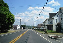
PA 248 eastbound in Berlinsville
USA Pennsylvania location map.svg
Red pog.svg
Berlinsville
Location of Berlinsville in Pennsylvania
Usa edcp location map.svg
Red pog.svg
Berlinsville
Berlinsville (the United States)
Coordinates: 40°46′7″N75°34′26″W / 40.76861°N 75.57389°W / 40.76861; -75.57389
Country Flag of the United States.svg  United States
State Flag of Pennsylvania.svg  Pennsylvania
County Northampton
Township Lehigh
Elevation
176 m (577 ft)
Population
   Metro
865,310 (US: 68th)
Time zone UTC-5 (Eastern (EST))
  Summer (DST) UTC-4 (EDT)
Area codes 610 and 484
GNIS feature ID1169304 [1]

Berlinsville is an unincorporated community in Lehigh Township in Northampton County, Pennsylvania. It is part of the Lehigh Valley metropolitan area, which had a population of 861,899 and was the 68th-most populous metropolitan area in the U.S. as of the 2020 census.

History and geography

The village is located at the intersection of Pennsylvania State Routes 248 and 946. [2]

The village is named for the Berlin family. Abraham Berlin emigrated to Northampton County from the Palatinate region of Germany in 1738. Berlin settled in Easton, where he was a blacksmith by trade and during the Revolutionary War served as chairman of the Northampton County Committee of Safety. Berlin's grandson, Abraham Berlin III, who was born in Easton in 1777, later settled in what is now Berlinsville. [3]

Related Research Articles

<span class="mw-page-title-main">Northampton County, Pennsylvania</span> County in Pennsylvania, United States

Northampton County is a county in the Commonwealth of Pennsylvania, United States. As of the 2020 census, the population was 312,951. Its county seat is Easton. The county was formed in 1752 from parts of Bucks County. Its namesake was the county of Northamptonshire in England, and the county seat of Easton was named for the country house Easton Neston in Northamptonshire.

<span class="mw-page-title-main">Whitehall Township, Lehigh County, Pennsylvania</span> Township in Pennsylvania, United States

Whitehall Township is a township with home rule status in Lehigh County, Pennsylvania. The township's population was 26,738 as of the 2010 census.

<span class="mw-page-title-main">Allen Township, Northampton County, Pennsylvania</span> Township in Pennsylvania, United States

Allen Township is a township in Northampton County, Pennsylvania. The population of Allen Township was 4,269 at the 2010 census. Allen Township is part of the Lehigh Valley metropolitan area, which had a population of 861,899 and was the 68th-most populous metropolitan area in the U.S. as of the 2020 census.

<span class="mw-page-title-main">Bethlehem Township, Northampton County, Pennsylvania</span> Place in Pennsylvania, United States

Bethlehem Township is a township in Northampton County, Pennsylvania, United States. The population of Bethlehem Township was 23,730 at the 2010 census. It is a suburb of Bethlehem and is part of the Lehigh Valley metropolitan statistical area, which had a population of 861,899 and was the 68th-most populous metropolitan area in the U.S. as of the 2020 census.

<span class="mw-page-title-main">Easton, Pennsylvania</span> City in Pennsylvania, United States

Easton is a city in, and the county seat of, Northampton County, Pennsylvania, United States. The city's population was 28,127 as of the 2020 census. Easton is located at the confluence of the Lehigh River, a 109-mile-long (175 km) river that joins the Delaware River in Easton and serves as the city's eastern geographic boundary with Phillipsburg, New Jersey.

<span class="mw-page-title-main">Forks Township, Northampton County, Pennsylvania</span> Place in Pennsylvania, United States

Forks Township is a township in Northampton County, Pennsylvania. The population of Forks Township was 14,721 as of the 2010 census. It is part of the Lehigh Valley metropolitan area, which had a population of 861,899 and was the 68th-most populous metropolitan area in the U.S. as of the 2020 census. The township is home to the global headquarters of Crayola, founded in 1885, a global arts supply company and the world's leading manufacturer of crayons.

<span class="mw-page-title-main">Lehigh Township, Northampton County, Pennsylvania</span> Place in Pennsylvania, United States

Lehigh Township is a township in Northampton County, Pennsylvania. The population of Lehigh Township was 10,526 as of the 2010 census. It is part of the Lehigh Valley metropolitan area, which had a population of 861,899 and was the 68th-most populous metropolitan area in the U.S. as of the 2020 census.

<span class="mw-page-title-main">Moore Township, Northampton County, Pennsylvania</span> Place in Pennsylvania, United States

Moore Township is a township in Northampton County, Pennsylvania. The population of Moore Township was 9,198 at the 2010 census. The township is located in the Lehigh Valley, which had a population of 861,899 and was the 68th-most populous metropolitan area in the U.S. as of the 2020 census.

<span class="mw-page-title-main">Palmer Township, Northampton County, Pennsylvania</span> Place in Pennsylvania, United States

Palmer Township is a township in Northampton County, Pennsylvania. The population of Palmer Township was 20,691 at the 2010 census.

<span class="mw-page-title-main">Wilson, Pennsylvania</span> Borough in Pennsylvania, United States

Wilson is a borough in Northampton County, Pennsylvania. The population was 8,259 at the 2020 census. Wilson is located adjacent to the city of Easton and is part of the Lehigh Valley metropolitan area, which had a population of 861,899 and was the 68th-most populous metropolitan area in the U.S. as of the 2020 census.

<span class="mw-page-title-main">Pennsylvania Route 248</span> State highway in Pennsylvania, US

Pennsylvania Route 248 is a 31.3 mi (50.4 km) long state highway in the eastern part of the U.S. state of Pennsylvania. The western terminus of the route is at U.S. Route 209 in Weissport East, a CDP in Franklin Township. The eastern terminus is at PA 611 in Easton. The route begins at US 209 in Carbon County and heads southeast parallel to the Lehigh River as a four-lane divided highway to Bowmanstown, where it becomes a freeway and heads through Palmerton. Upon crossing Lehigh Gap in Blue Mountain, PA 248 enters Northampton County and becomes a two-lane undivided highway that heads southeast through rural areas, serving Bath and Nazareth. From here, the route runs southeast through suburban areas to Wilson, where it turns east and follows city streets through Easton.

<span class="mw-page-title-main">Pennsylvania Route 245</span>

Pennsylvania Route 245 was a 2.10-mile-long (3.38 km) east–west state highway located in the U.S. state of Pennsylvania. Commissioned in 1928, the designation began at U.S. Route 309 in Slatington, east to PA 45 in Berlinsville. Today, the US 309 alignment has become PA 873 and the PA 45 designation has become PA 248. PA 245 was decommissioned in the 1940s.

<span class="mw-page-title-main">Cherryville, Pennsylvania</span> Census-designated place in Pennsylvania, United States

Cherryville is a census-designated place in Lehigh Township in Northampton County, Pennsylvania. Its population was 1,618 as of the 2020 U.S. census.

Newburg is a village located in Lower Nazareth Township in Northampton County, Pennsylvania. The village is located at the eastern terminus of Route 946 at Route 191. Newburg is part of the Lehigh Valley metropolitan area, which had a population of 861,899 and was the 68th-most populous metropolitan area in the U.S. as of the 2020 census.

<span class="mw-page-title-main">Butztown, Pennsylvania</span> Unincorporated community in Pennsylvania, United States

Butztown is an unincorporated community in Bethlehem Township, Pennsylvania. It is located northeast of Bethlehem. The village is part of the Lehigh Valley metropolitan area, which had a population of 861,899 and was the 68th-most populous metropolitan area in the U.S. as of the 2020 census.

<span class="mw-page-title-main">Ackermanville, Pennsylvania</span> Census-designated place in Pennsylvania, United States

Ackermanville is a census-designated place located on PA Route 191 in Washington Township, Pennsylvania. As of the 2020 census, the village's population was 572. Ackermanville is part of the Lehigh Valley metropolitan area, which had a population of 861,899 and was the 68th-most populous metropolitan area in the U.S. as of the 2020 census. It was named for the Ackerman family.

Beersville, originally known as Falmers, is an exurban unincorporated village in southwestern Moore Township, Pennsylvania near the Lehigh Township line on Route 248. It is part of the Lehigh Valley metropolitan area, which had a population of 861,899 and which was thus the 68th-most populous metropolitan area in the U.S. as of the 2020 census.

Treichlers is an unincorporated community along the Lehigh River in Lehigh Township in Northampton County, Pennsylvania. The village is part of the Lehigh Valley metropolitan area, which had a population of 861,899 and was the 68th-most populous metropolitan area in the U.S. as of the 2020 census.

Balliettsville is an unincorporated community in North Whitehall Township in Lehigh County, Pennsylvania. It is part of the Lehigh Valley, which had a population of 861,899 and was the 68th-most populous metropolitan area in the U.S. as of the 2020 census.

Chestnut Hill is an unincorporated community and census-designated place (CDP) in Northampton County, Pennsylvania. It was first listed as a CDP prior to the 2020 census. Its population as of the 2020 census was 6,689. It is part of the Lehigh Valley metropolitan area, which had a population of 861,899 and was the 68th-most populous metropolitan area in the U.S. as of 2020.

References

  1. "Berlinsville". Geographic Names Information System . United States Geological Survey, United States Department of the Interior.
  2. Northampton County Maps: Lehigh Township (PDF) (Map). PennDOT. 2022. Retrieved April 10, 2022.
  3. Wright, James; Wright, Wright (1988). Place Names of Northampton County, Pennsylvania. Nazareth, Pennsylvania: J&L Wright. pp. 15–16.