
York County is a county in the Commonwealth of Pennsylvania. As of the 2020 census, the population was 456,438. Its county seat is York. The county was created on August 19, 1749, from part of Lancaster County and named either after the Duke of York, an early patron of the Penn family, or for the city and county of York in England.

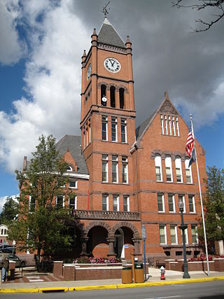
Northampton County is a county in the Commonwealth of Pennsylvania, United States. As of the 2020 census, the population was 312,951. Its county seat is Easton. The county was formed in 1752 from parts of Bucks County. Its namesake was the county of Northamptonshire in England, and the county seat of Easton was named for the country house Easton Neston in Northamptonshire.
Columbia County is a county in the Commonwealth of Pennsylvania. It is located in Northeastern Pennsylvania. As of the 2020 census, the population was 64,727. Its county seat is Bloomsburg. The county was created on March 22, 1813, from part of Northumberland County. It was named Columbia, alluding to the United States and Christopher Columbus.

Lower Nazareth Township is a township in Northampton County, Pennsylvania. The population of Lower Nazareth Township was 5,674 at the 2010 census. The township is located in the Lehigh Valley, which had a population of 861,899 and was the 68th-most populous metropolitan area in the U.S. as of the 2020 census.
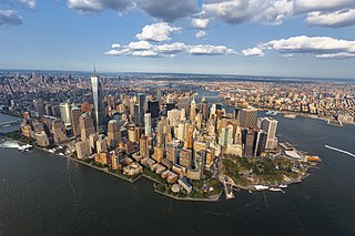
The New York metropolitan area, broadly referred to as the Tri-State area and often also called Greater New York, is the largest metropolitan area in the world by urban landmass, encompassing 4,669.0 sq mi (12,093 km2). The New York metropolitan area is one of the most populous metropolitan areas in the world, the world's largest metropolitan area by size, and the only U.S. metropolitan area larger than twenty million residents as of the 2020 United States census. The vast metropolitan area includes New York City, the nation's most populous city, Long Island, the Mid- and Lower Hudson Valley in New York State; fourteen counties and eleven of the largest cities in New Jersey; and six of the seven largest cities in Connecticut. The phrase "Tri-State area" usually refers to New York / New Jersey / Connecticut, although an increasing number of people who work in New York City commute from Pennsylvania, particularly from the Lehigh Valley, Bucks County, and Poconos regions in eastern Pennsylvania. The New York metropolitan area is the geographic and demographic hub of the larger Northeast megalopolis.

The Delaware Valley, sometimes referred to as Greater Philadelphia or the Philadelphia metropolitan area, is a metropolitan region in the Northeast on the East Coast of the United States that centers on Philadelphia and spans four U.S. states: southeastern Pennsylvania, southern New Jersey, northern Delaware, and the northern Eastern Shore of Maryland. As of the 2020 census, the core metropolitan statistical area of the Delaware Valley had a total population of 6.288 million residents, making it the nation's seventh-largest, the continent's eighth-largest, and the world's 35th-largest metropolitan area. The combined statistical area of the Delaware Valley is even larger with a total population of 7.366 million.

Anselm Paul Alexis Hollo was a Finnish poet and translator. He lived in the United States from 1967 until his death in January 2013.

The Wyoming Valley is a historic industrialized region of Northeastern Pennsylvania. The region is historically notable for its influence in helping fuel the American Industrial Revolution with its many anthracite coal-mines. As a metropolitan area, it is known as the Scranton/Wilkes-Barre metropolitan area, after its principal cities, Scranton and Wilkes-Barre. With a population of 567,559 as of the 2020 United States census, it is the fifth-largest metropolitan area in Pennsylvania, after the Delaware Valley, Greater Pittsburgh, the Lehigh Valley, and the Harrisburg–Carlisle metropolitan statistical areas.

Greater Pittsburgh is the metropolitan area surrounding the city of Pittsburgh in Western Pennsylvania, United States. The region includes Allegheny County, Pittsburgh's urban core county and economic hub, and seven adjacent Pennsylvania counties: Armstrong, Beaver, Butler, Fayette, Lawrence, Washington, and Westmoreland in Western Pennsylvania, which constitutes the Pittsburgh, PA Metropolitan Statistical Area MSA as defined by the U.S. Census Bureau.
Pennsylvania has fourteen metropolitan statistical areas (MSAs) and four combined statistical areas (CSAs), as defined by the United States Census Bureau. As of 2020, Philadelphia, the seventh-largest United States metropolitan area, is the state's largest metropolitan area followed by Pittsburgh and Allentown.
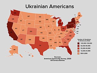
Ukrainian Americans are Americans who are of Ukrainian ancestry. According to U.S. census estimates, in 2021 there were 1,017,586 Americans of Ukrainian descent representing 0.3% of the American population. The Ukrainian population of the United States is thus the second largest outside the former Eastern Bloc; only Canada has a larger Ukrainian community under this definition. According to the 2000 U.S. census, the metropolitan areas with the largest numbers of Ukrainian Americans are: New York City with 160,000; Philadelphia with 60,000; Chicago with 46,000; Detroit with 45,000; Los Angeles with 36,000; Cleveland with 26,000; Sacramento with 20,000; and Indianapolis with 19,000. In 2018, the number of Ukrainian Americans surpassed 1 million.
The following is a set–index article, providing a list of lists, for the cities, towns and villages within the jurisdictional United States. It is divided, alphabetically, according to the state, territory, or district name in which they are located.

The Harrisburg–Carlisle metropolitan statistical area, officially the Harrisburg–Carlisle, PA Metropolitan Statistical Area, and also referred to as the Susquehanna Valley, is defined by the Office of Management and Budget as an area consisting of three counties in South Central Pennsylvania, anchored by the cities of Harrisburg and Carlisle.

The Youngstown–Warren, OH Metropolitan Statistical Area, typically known as the Mahoning Valley, is a metropolitan area in Northeast Ohio with Youngstown, Ohio, at its center. According to the U.S. Census Bureau, the metropolitan statistical area (MSA) includes Mahoning and Trumbull counties. As of the 2020 census, the region had a population of 541,243, making it the 107th largest metro area in the country.
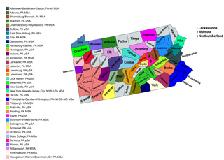
The United States Commonwealth of Pennsylvania currently has 49 statistical areas that have been delineated by the Office of Management and Budget (OMB). On March 6, 2020, the OMB delineated 12 combined statistical areas, 20 metropolitan statistical areas, and 17 micropolitan statistical areas in Pennsylvania.

The Harrisburg–York–Lebanon, PA Combined Statistical Area (CSA) is a region assigned by the U.S. Office of Management Budget that includes six cities in the Harrisburg and York areas along with several Metropolitan statistical areas of Pennsylvania that combine to form a Combined statistical area. As of the 2010 United States census, the CSA had a population total of 1,219,422, and ranked the third most populous CSA in Pennsylvania and 43rd most populous in the nation.
Franks Corner is an unincorporated community located within East Allen Township in Northampton County, Pennsylvania. It is part of the Lehigh Valley metropolitan area, which had a population of 861,899 and was the 68th-most populous metropolitan area in the United States as of the 2020 census.

