
Bethlehem is a city in the West Bank, Palestine, located about 10 kilometres (6.2 mi) south of Jerusalem. It is the capital of the Bethlehem Governorate, and has a population of approximately 25,000 people. The city's economy is largely tourist-driven; international tourism peaks around and during Christmas, when Christians embark on a pilgrimage to the Church of the Nativity, revered as the location of the Nativity of Jesus. At the northern entrance of the city is Rachel's Tomb, the burial place of biblical matriarch Rachel. Movement around the city is limited due to the Israeli West Bank barrier.

Pennsylvania, officially the Commonwealth of Pennsylvania, is a state spanning the Mid-Atlantic, Northeastern, Appalachian, and Great Lakes regions of the United States. Pennsylvania borders Delaware to its southeast, Maryland to its south, West Virginia to its southwest, Ohio to its west, Lake Erie and the Canadian province of Ontario to its northwest, New York to its north, and the Delaware River and New Jersey to its east.

Lititz is a borough in Lancaster County, Pennsylvania, United States, 9 miles (14 km) north of the city of Lancaster. As of the 2020 census, it had a population of 9,370.

Northampton County is a county in the Commonwealth of Pennsylvania, United States. As of the 2020 census, the population was 312,951. Its county seat is Easton. The county was formed in 1752 from parts of Bucks County. Its namesake was the county of Northamptonshire in England, and the county seat of Easton was named for the country house Easton Neston in Northamptonshire.

Clarion County is a county in the Commonwealth of Pennsylvania. As of the 2020 census, the population was 37,241. Its county seat is Clarion. The county was formed on March 11, 1839, from parts of Venango and Armstrong counties. Clarion County is entirely defined as part of the Pittsburgh media market. Clarion County is in the sparsely populated Pennsylvania Wilds region.

New Bethlehem is a borough in Clarion County, Pennsylvania, United States. The population was 979 at the 2020 census. The borough is situated at the southwestern corner of the Pennsylvania Wilds Conservation Landscape. Its main street, PA Route 28-66, is a major thoroughfare between the Pittsburgh metropolitan region and northcentral Pennsylvania.

Macungie is the second oldest borough in Lehigh County, Pennsylvania. As of the 2020 census, Macungie had a population of 3,257.

Salisbury Township is a township in Lehigh County, Pennsylvania. The township's population was 13,505 at the 2010 census. The township borders Allentown, Pennsylvania's third-largest city, Bethlehem, and Emmaus, in the Lehigh Valley, which had a population of 861,899 and was the 68th-most populous metropolitan area in the U.S. as of the 2020 census.

Bethlehem Township is a township in Northampton County, Pennsylvania, United States. The population of Bethlehem Township was 23,730 at the 2010 census. It is a suburb of Bethlehem and is part of the Lehigh Valley metropolitan statistical area, which had a population of 861,899 and was the 68th-most populous metropolitan area in the U.S. as of the 2020 census.

Easton is a city in, and the county seat of, Northampton County, Pennsylvania, United States. The city's population was 28,127 as of the 2020 census. Easton is located at the confluence of the Lehigh River, a 109-mile-long (175 km) river that joins the Delaware River in Easton and serves as the city's eastern geographic boundary with Phillipsburg, New Jersey.

Freemansburg is a borough in Northampton County, Pennsylvania. The population of Freemansburg was 2,875 as of the 2020 census. The Lehigh River, a 109-mile-long (175 km) tributary of the Delaware River, flows through Freemansburg.

Hanover Township is a township in Northampton County, Pennsylvania. The population of Hanover Township was 10,866 at the 2010 census.

Hellertown is a borough in Northampton County, Pennsylvania. Its population was 6,131 at the 2020 census. Hellertown is part of the Lehigh Valley metropolitan area, which had a population of 861,899 and was the 68th-most populous metropolitan area in the U.S. as of 2020.

Nazareth is a borough in Northampton County, Pennsylvania, United States. The borough's population was 6,053 at the 2020 census. Nazareth is part of the Lehigh Valley metropolitan area, which had a population of 861,899 and was the 68th-most populous metropolitan area in the U.S. as of 2020.

Palmer Township is a township in Northampton County, Pennsylvania. The population of Palmer Township was 20,691 at the 2010 census.

Bethlehem is a city in Northampton and Lehigh Counties in the Lehigh Valley region of eastern Pennsylvania, United States. As of the 2020 census, Bethlehem had a total population of 75,781. Among its total population as of 2020, 55,639 were in Northampton County and 19,343 were in Lehigh County. It is Pennsylvania's seventh-most populous city. The city is located along the Lehigh River, a 109-mile-long (175 km) tributary of the Delaware River.
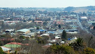
Bethlehem is a city in the eastern Free State province of South Africa that is situated on the Liebenbergs river along a fertile valley just north of the Rooiberg Mountains on the N5 road. It is the fastest growing city in the Free state province, with its target of being the third largest city after Bloemfontein and Welkom.

Cheltenham Township is a Home Rule Municipality and Township of the First Class located in the southeast corner of Montgomery County, Pennsylvania, United States. It borders the City of Philadelphia to the south and east, Abington Township and the borough of Jenkintown to the north, and Springfield Township to the west.


