Moorestown, Pennsylvania

Last updated

Moorestown, Pennsylvania
Unincorporated community
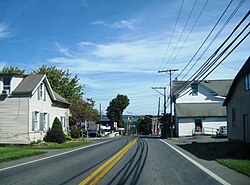
PA 512 nb approaching PA 946, Moorestown, PA (2), Sept. 2023.jpg
Moorestown on Pennsylvania Route 512
USA Pennsylvania location map.svg
Red pog.svg
Moorestown
Coordinates: 40°46′43″N75°22′11″W / 40.77861°N 75.36972°W / 40.77861; -75.36972
Country Flag of the United States.svg  United States
State Flag of Pennsylvania.svg  Pennsylvania
County Northampton
Township Moore
Elevation
234 m (768 ft)
Population
   Metro
865,310 (US: 68th)
Time zone UTC-5 (Eastern (EST))
  Summer (DST) UTC-4 (EDT)
Area code(s) 610 and 484
GNIS feature ID1181518 [1]

Moorestown (also Mooresburg) is an unincorporated community in Moore Township in Northampton County, Pennsylvania. It is part of the Lehigh Valley metropolitan area, which had a population of 861,899 and was the 68th-most populous metropolitan area in the U.S. as of the 2020 census.

Moorestown is located at the intersection of Pennsylvania State Routes 512 and 946. [2]

Related Research Articles

<span class="mw-page-title-main">Northampton County, Pennsylvania</span> County in Pennsylvania, United States

Northampton County is a county in the Commonwealth of Pennsylvania, United States. As of the 2020 census, the population was 312,951. Its county seat is Easton. The county was formed in 1752 from parts of Bucks County. Its namesake was the county of Northamptonshire in England, and the county seat of Easton was named for the country house Easton Neston in Northamptonshire.

<span class="mw-page-title-main">Allen Township, Northampton County, Pennsylvania</span> Township in Pennsylvania, United States

Allen Township is a township in Northampton County, Pennsylvania. The population of Allen Township was 4,269 at the 2010 census. Allen Township is part of the Lehigh Valley metropolitan area, which had a population of 861,899 and was the 68th-most populous metropolitan area in the U.S. as of the 2020 census.

<span class="mw-page-title-main">Chapman, Pennsylvania</span> Borough in Pennsylvania, United States

Chapman is a borough in Northampton County, Pennsylvania. The population of Chapman was 223 as of the 2020 census. Chapman is part of the Lehigh Valley metropolitan area, which had a population of 861,899 and was the 68th-most populous metropolitan area in the U.S. as of the 2020 census.

<span class="mw-page-title-main">Hanover Township, Northampton County, Pennsylvania</span> Place in Pennsylvania, United States

Hanover Township is a township in Northampton County, Pennsylvania. The population of Hanover Township was 10,866 at the 2010 census.

<span class="mw-page-title-main">Moore Township, Pennsylvania</span> Place in Pennsylvania, United States

Moore Township is a township in Northampton County, Pennsylvania. The population of Moore Township was 9,198 at the 2010 census. The township is located in the Lehigh Valley, which had a population of 861,899 and was the 68th-most populous metropolitan area in the U.S. as of the 2020 census.

<span class="mw-page-title-main">Northampton, Pennsylvania</span> Borough in Pennsylvania, United States

Northampton is a borough in Northampton County, Pennsylvania. Its population was 10,395 as of the 2020 census. Northampton is located 7.8 miles (12.6 km) north of Allentown, 66.7 miles (107.3 km) northwest of Philadelphia, and 93.8 miles (151.0 km) west of New York City.

<span class="mw-page-title-main">Upper Mount Bethel Township, Pennsylvania</span> Place in Pennsylvania, United States

Upper Mount Bethel Township is a township in Northampton County, Pennsylvania. The population of Upper Mount Bethel Township was 6,706 at the 2010 census. The township is part of the Lehigh Valley metropolitan area, which had a population of 861,899 and was the 68th-most populous metropolitan area in the U.S. as of the 2020 census.

<span class="mw-page-title-main">Wilson, Pennsylvania</span> Borough in Pennsylvania, United States

Wilson is a borough in Northampton County, Pennsylvania. The population was 8,259 at the 2020 census. Wilson is located adjacent to the city of Easton and is part of the Lehigh Valley metropolitan area, which had a population of 861,899 and was the 68th-most populous metropolitan area in the U.S. as of the 2020 census.

<span class="mw-page-title-main">Pennsylvania Route 512</span> State highway in Northampton County, Pennsylvania, US

Pennsylvania Route 512 is a 26.1-mile-long (42.0 km) state route in Northampton County in the Lehigh Valley region in eastern Pennsylvania. The southern terminus is at U.S. Route 22 north of Bethlehem in Hanover Township. The northern terminus is at PA 611 in Upper Mount Bethel Township. The route heads north from US 22 to Bath, where it intersects PA 248. From here, PA 512 continues northeast and intersects PA 946 in Moorestown before it reaches an interchange with the PA 33 freeway in Wind Gap. The route heads east through the northern Northampton County boroughs of Wind Gap, Pen Argyl, Bangor, and East Bangor, intersecting PA 191 in Bangor. It then continues east to PA 611.

<span class="mw-page-title-main">Pennsylvania Route 946</span> State highway in Northampton County, Pennsylvania, US

Pennsylvania Route 946 is a rural Pennsylvania state highway that runs approximately 18.2 miles (29.3 km) from PA 248 in Berlinsville east to PA 191 in Newburg in Northampton County in the Lehigh Valley region of the state.

<span class="mw-page-title-main">Cementon, Pennsylvania</span> Census-designated place in Pennsylvania, United States

Cementon is an unincorporated area and census-designated place (CDP) in Lehigh County, Pennsylvania. The town is in Whitehall Township, 7 miles (11 km) north of Allentown. As of the 2020 census, the population of Cementon was 1,657. Cementon is part of the Lehigh Valley metropolitan area, which had a population of 861,899 and was the 68th-most populous metropolitan area in the U.S. as of 2020. It uses the Whitehall Township ZIP Code of 18052.

<span class="mw-page-title-main">Butztown, Pennsylvania</span> Unincorporated community in Pennsylvania, United States

Butztown is an unincorporated community in Bethlehem Township, Pennsylvania. It is located northeast of Bethlehem. The village is part of the Lehigh Valley metropolitan area, which had a population of 861,899 and was the 68th-most populous metropolitan area in the U.S. as of the 2020 census.

Beersville, originally known as Falmers, is an exurban unincorporated village in southwestern Moore Township, Pennsylvania near the Lehigh Township line on Route 248. It is part of the Lehigh Valley metropolitan area, which had a population of 861,899 and which was thus the 68th-most populous metropolitan area in the U.S. as of the 2020 census.

Klecknersville is an unincorporated community in Moore Township in Northampton County, Pennsylvania. It is part of the Lehigh Valley metropolitan area, which had a population of 861,899 and was the 68th-most populous metropolitan area in the U.S. as of the 2020 census.

<span class="mw-page-title-main">Berlinsville, Pennsylvania</span> Unincorporated community in Pennsylvania, United States

Berlinsville is an unincorporated community in Lehigh Township in Northampton County, Pennsylvania. It is part of the Lehigh Valley metropolitan area, which had a population of 861,899 and was the 68th-most populous metropolitan area in the U.S. as of the 2020 census.

Emanuelsville is an unincorporated community in Moore Township in Northampton County, Pennsylvania. It is part of the Lehigh Valley metropolitan area, which had a population of 861,899 was the 68th-most populous metropolitan area in the U.S. as of the 2020 census.

<span class="mw-page-title-main">Hanoverville, Pennsylvania</span> Unincorporated community in Pennsylvania, United States

Hanoverville is an unincorporated community in Northampton County, Pennsylvania. It is part of the Lehigh Valley metropolitan area, which had a population of 861,899 and was the 68th-most populous metropolitan area in the U.S. as of the 2020 census.

Balliettsville is an unincorporated community in North Whitehall Township in Lehigh County, Pennsylvania. It is part of the Lehigh Valley, which had a population of 861,899 and was the 68th-most populous metropolitan area in the U.S. as of the 2020 census.

<span class="mw-page-title-main">Mount Bethel, Pennsylvania</span> Unincorporated community in Pennsylvania, United States

Mount Bethel is an unincorporated community in Upper Mount Bethel Township in Northampton County, Pennsylvania. It is part of the Lehigh Valley metropolitan area, which had a population of 861,899 and was the 68th-most populous metropolitan area in the U.S. as of the 2020 census.

Franks Corner is an unincorporated community located within East Allen Township in Northampton County, Pennsylvania. It is part of the Lehigh Valley metropolitan area, which had a population of 861,899 and was the 68th-most populous metropolitan area in the United States as of the 2020 census.

References

  1. "Moorestown". Geographic Names Information System . United States Geological Survey, United States Department of the Interior.
  2. Northampton County, Pennsylvania Highway Map (PDF) (Map). PennDOT. 2012. Retrieved August 21, 2013.[ permanent dead link ]