Bushkill Township, Pennsylvania

Last updated

Bushkill Township, Pennsylvania
Jacobsburg2.JPG
Bushkill Township Seal.png
Northampton county - Bushkill Township.png
Location of Bushkill Township in Northampton County, Pennsylvania
USA Pennsylvania location map.svg
Red pog.svg
Bushkill Township, Pennsylvania
Location of Bushkill Township in Pennsylvania
Coordinates: 40°44′59″N75°20′29″W / 40.74972°N 75.34139°W / 40.74972; -75.34139
Country Flag of the United States.svg  United States
State Flag of Pennsylvania.svg  Pennsylvania
County Northampton
Founded1813
Area
[1]
   Township 25.25 sq mi (65.40 km2)
  Land24.93 sq mi (64.56 km2)
  Water0.32 sq mi (0.84 km2)
Elevation
659 ft (201 m)
Population
 (2010)
   Township 8,178
  Estimate 
(2016) [2]
8,450
  Density338.99/sq mi (130.89/km2)
   Metro
865,310 (US: 68th)
Time zone UTC-5 (EST)
  Summer (DST) UTC-4 (EDT)
Area code(s) 610
FIPS code 42-095-10400
Primary airport Lehigh Valley International Airport
Major hospital Lehigh Valley Hospital–Cedar Crest
School district Nazareth Area
Website www.bushkilltownship.org

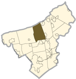
Bushkill Township is a township in Northampton County, Pennsylvania, United States. Its population was 8,178 at the 2010 census. It is part of the Lehigh Valley metropolitan area, which had a population of 861,899 and was the 68th-most populous metropolitan area in the U.S. as of the 2020 census.

Contents

Geography

According to the U.S. Census Bureau, the township has a total area of 25.3 square miles (66 km2), of which 25.3 square miles (66 km2) is land and 0.1 square miles (0.26 km2) (0.20%) is water. It is in the Delaware River watershed and is drained by the Bushkill Creek, except for a very small area in the southwest drained by the Mononacy Creek into the Lehigh River.

Blue Mountain forms its natural northern boundary. Its villages include Bushkill Center, Cherry Hill, Clearfield, Copella (also in Moore Township,) Katellen, and Rismiller.

Neighboring municipalities

Demographics

Historical population
CensusPop.Note
2000 6,982
2010 8,17817.1%
2016 (est.)8,450 [2] 3.3%
U.S. Decennial Census [3]

As of the census of 2000, [4] there were 6,982 people, 2,333 households, and 2,011 families residing in the township. The population density was 276.1 inhabitants per square mile (106.6/km2). There were 2,406 housing units at an average density of 95.2 units per square mile (36.8 units/km2). The racial makeup of the township was 98.27% White, 0.19% African American, 0.24% Native American, 0.39% Asian, 0.34% from other races, and 0.57% from two or more races. Hispanic or Latino of any race were 1.00% of the population.

There were 2,333 households, out of which 42.0% had children under the age of 18 living with them, 76.4% were married couples living together, 6.1% had a female householder with no husband present, and 13.8% were non-families. 11.1% of all households were made up of individuals, and 5.2% had someone living alone who was 65 years of age or older. The average household size was 2.99 and the average family size was 3.22.

In the township, the population was spread out, with 28.1% under the age of 18, 5.9% from 18 to 24, 29.8% from 25 to 44, 26.9% from 45 to 64, and 9.3% who were 65 years of age or older. The median age was 38 years. For every 100 females, there were 101.0 males. For every 100 females age 18 and over, there were 99.2 males.

The median income for a household in the township was $63,966, and the median income for a family was $67,649. Males had a median income of $42,097 versus $30,275 for females. The per capita income for the township was $23,569. About 1.9% of families and 3.1% of the population were below the poverty line, including 1.3% of those under age 18 and 10.3% of those age 65 or over.

Transportation

PA Route 33 South in Bushkill Township 2022-09-27 13 05 33 View south along Pennsylvania State Route 33 just south of the exit for Belfast in Bushkill Township, Northampton County, Pennsylvania.jpg
PA Route 33 South in Bushkill Township

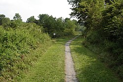
As of 2016, there were 93.91 miles (151.13 km) of public roads in Bushkill Township, of which 35.67 miles (57.41 km) were maintained by the Pennsylvania Department of Transportation (PennDOT) and 58.24 miles (93.73 km) were maintained by the township. [5]

Pennsylvania Route 33, Pennsylvania Route 512, and Pennsylvania Route 946 are the numbered highways serving Bushkill Township. PA 33 follows a north–south alignment along the eastern edge of the township, PA 512 follows a northeast–southwest alignment across the northern and western portions of the township, and PA 946 follows a northwest–southeast alignment across the far southwestern corner of the township.

Education

Bushkill Township is served by the Nazareth Area School District. High school students attend Nazareth Area High School in Nazareth. Middle school students attend Nazareth Area Middle School.

Public safety

Bushkill Township Volunteer Fire Company provides fire rescue and basic and advanced life support services to all residents and travelers in the township.

Related Research Articles

<span class="mw-page-title-main">East Penn Township, Pennsylvania</span> Place in Pennsylvania, United States

East Penn Township is a rural township in the rough uplands terrain of the eastern Mahoning Hills area of Carbon County, Pennsylvania. It is part of Northeastern Pennsylvania.

<span class="mw-page-title-main">North Whitehall Township, Pennsylvania</span> Township in Pennsylvania, United States

North Whitehall Township is a township in Lehigh County, Pennsylvania, United States. The population of North Whitehall Township was 15,655 at the 2020 census. It is a suburb of Allentown in the Lehigh Valley, which had a population of 861,899 and was the 68th-most populous metropolitan area in the U.S. as of the 2020 census.

<span class="mw-page-title-main">Upper Milford Township, Pennsylvania</span> Township in Pennsylvania, United States

Upper Milford Township is a township in Lehigh County, Pennsylvania, United States. The township's population was 7,292 at the 2010 census. Upper Milford Township is a rural area southwest of Allentown in the Lehigh Valley, which had a population of 861,899 and was the 68th-most populous metropolitan area in the U.S. as of the 2020 census.

<span class="mw-page-title-main">Washington Township, Lehigh County, Pennsylvania</span> Township in Pennsylvania, United States

Washington Township is a township in Lehigh County, Pennsylvania, United States. The population of Washington Township was 6,624 at the 2010 census. It is a suburb of Allentown in the Lehigh Valley, which had a population of 861,899 and was the 68th-most populous metropolitan area in the U.S. as of the 2020 census.

<span class="mw-page-title-main">Upper Hanover Township, Pennsylvania</span> Township in Pennsylvania, United States

Upper Hanover Township is a township in Montgomery County, Pennsylvania, United States. The population was 6,464 at the 2010 census.

<span class="mw-page-title-main">Allen Township, Northampton County, Pennsylvania</span> Township in Pennsylvania, United States

Allen Township is a township in Northampton County, Pennsylvania, United States. The population of Allen Township was 4,269 at the 2010 census. Allen Township is part of the Lehigh Valley metropolitan area, which had a population of 861,899 and was the 68th-most populous metropolitan area in the U.S. as of the 2020 census.

<span class="mw-page-title-main">Bethlehem Township, Pennsylvania</span> Place in Pennsylvania, United States

Bethlehem Township is a township in Northampton County, Pennsylvania, United States. The population of Bethlehem Township was 23,730 at the 2010 census. It is a suburb of Bethlehem and is part of the Lehigh Valley metropolitan statistical area, which had a population of 861,899 and was the 68th-most populous metropolitan area in the U.S. as of the 2020 census.

<span class="mw-page-title-main">East Allen Township, Pennsylvania</span> Place in Pennsylvania, United States

East Allen Township is a township in Northampton County, Pennsylvania, United States. The population of East Allen Township was 4,903 at the 2010 census. East Allen is part of the Lehigh Valley metropolitan area, which had a population of 861,899 and was the 68th-most populous metropolitan area in the U.S. as of the 2020 census.

<span class="mw-page-title-main">Forks Township, Northampton County, Pennsylvania</span> Place in Pennsylvania, United States

Forks Township is a township in Northampton County, Pennsylvania, United States. The population of Forks Township was 14,721 as of the 2010 census. It is part of the Lehigh Valley metropolitan area, which had a population of 861,899 and was the 68th-most populous metropolitan area in the U.S. as of the 2020 census. The township is home to the global headquarters of Crayola, founded in 1885, a global arts supply company and the world's leading manufacturer of crayons.

<span class="mw-page-title-main">Hanover Township, Northampton County, Pennsylvania</span> Place in Pennsylvania, United States

Hanover Township is a township in Northampton County, Pennsylvania, United States. The population of Hanover Township was 10,866 at the 2010 census.

<span class="mw-page-title-main">Lehigh Township, Northampton County, Pennsylvania</span> Place in Pennsylvania, United States

Lehigh Township is a township in Northampton County, Pennsylvania, United States. The population of Lehigh Township was 10,526 as of the 2010 census. It is part of the Lehigh Valley metropolitan area, which had a population of 861,899 and was the 68th-most populous metropolitan area in the U.S. as of the 2020 census.

<span class="mw-page-title-main">Lower Nazareth Township, Pennsylvania</span> Place in Pennsylvania, United States

Lower Nazareth Township is a township in Northampton County, Pennsylvania, United States. The population of Lower Nazareth Township was 5,674 at the 2010 census. The township is located in the Lehigh Valley, which had a population of 861,899 and was the 68th-most populous metropolitan area in the U.S. as of the 2020 census.

<span class="mw-page-title-main">Moore Township, Pennsylvania</span> Place in Pennsylvania, United States

Moore Township is a township in Northampton County, Pennsylvania, United States. The population of Moore Township was 9,198 at the 2010 census. The township is located in the Lehigh Valley, which had a population of 861,899 and was the 68th-most populous metropolitan area in the U.S. as of the 2020 census.

<span class="mw-page-title-main">Palmer Township, Pennsylvania</span> Second Class Township in Pennsylvania, United States

Palmer Township is a township in Northampton County, Pennsylvania, United States. The population of Palmer Township was 22,317 at the 2020 census. It is the eight-largest municipality in the Lehigh Valley metropolitan area, which had a population of 861,899 and was the 68th-most populous metropolitan area in the U.S. as of the 2020 census.

<span class="mw-page-title-main">Plainfield Township, Pennsylvania</span> Place in Pennsylvania, United States

Plainfield Township is a township in Northampton County, Pennsylvania, United States. The population of Plainfield Township was 6,138 at the 2010 census. The township is part of the Lehigh Valley metropolitan area, which had a population of 861,899 and was the 68th-most populous metropolitan area in the U.S. as of the 2020 census.

<span class="mw-page-title-main">Stockertown, Pennsylvania</span> Place in Pennsylvania, United States

Stockertown is a borough in Northampton County, Pennsylvania. The borough's population was 927 as of the 2010 census. It is part of the Lehigh Valley metropolitan area, which had a population of 861,899 and was the 68th-most populous metropolitan area in the U.S. as of the 2010 census.

<span class="mw-page-title-main">Upper Mount Bethel Township, Pennsylvania</span> Place in Pennsylvania, United States

Upper Mount Bethel Township is a township in Northampton County, Pennsylvania, United States. The population of Upper Mount Bethel Township was 6,706 at the 2010 census. The township is part of the Lehigh Valley metropolitan area, which had a population of 861,899 and was the 68th-most populous metropolitan area in the U.S. as of the 2020 census.

<span class="mw-page-title-main">Upper Nazareth Township, Pennsylvania</span> Place in Pennsylvania, United States

Upper Nazareth Township is a township in Northampton County, Pennsylvania, United States. It is part of the Lehigh Valley metropolitan area, which had a population of 861,899 and was the 68th-most populous metropolitan area in the U.S. as of the 2020 census. At the 2010 census, Upper Nazareth Township's population was 6,231.

<span class="mw-page-title-main">Washington Township, Northampton County, Pennsylvania</span> Township in Pennsylvania, United States

Washington Township is a township in Northampton County, Pennsylvania, United States. The population of Washington Township was 5,122 at the 2010 census. Washington Township is part of the Lehigh Valley metropolitan area, which had a population of 861,899 and was the 68th-most populous metropolitan area in the U.S. as of the 2020 census.

<span class="mw-page-title-main">Wind Gap, Pennsylvania</span> Borough in Pennsylvania, United States

Wind Gap is a borough in Northampton County, Pennsylvania. The population of Wind Gap was 2,820 at the 2020 census. Wind Gap is part of the Lehigh Valley metropolitan area, which had a population of 861,899 and was the 68th-most populous metropolitan area in the U.S. as of the 2020 census.

References

  1. "2016 U.S. Gazetteer Files". United States Census Bureau. Retrieved August 14, 2017.
  2. 1 2 "Population and Housing Unit Estimates" . Retrieved June 9, 2017.
  3. "Census of Population and Housing". Census.gov. Retrieved June 4, 2016.
  4. "U.S. Census website". United States Census Bureau . Retrieved January 31, 2008.
  5. "Bushkill Township map" (PDF). PennDOT. Retrieved March 16, 2023.