Mickleys, Pennsylvania

Last updated

Mickleys, Pennsylvania
Unincorporated community
St. John's United Church of Christ, Mickleys, PA.jpg
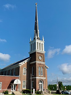
St. John's United Church of Christ in Mickleys
USA Pennsylvania location map.svg
Red pog.svg
Mickleys
Location of Mickleys in Pennsylvania
Usa edcp location map.svg
Red pog.svg
Mickleys
Mickleys (the United States)
Coordinates: 40°38′50″N75°29′44″W / 40.64722°N 75.49556°W / 40.64722; -75.49556
Country Flag of the United States.svg  United States
State Flag of Pennsylvania.svg  Pennsylvania
County Lehigh
Township Whitehall
Elevation
117 m (384 ft)
Population
   Metro
865,310 (US: 68th)
Time zone UTC-5 (Eastern (EST))
  Summer (DST) UTC-4 (EDT)
ZIP code
18052
GNIS feature ID1204164 [1]

Mickleys is an unincorporated community that is located in Whitehall Township in Lehigh County, Pennsylvania. It is situated on Pennsylvania Route 145, also known as MacArthur Road. It is part of the Lehigh Valley, which has a population of 861,899 and is the 68th-most populous metropolitan area in the U.S. as of the 2020 census.

History

This Pennsylvania village was named after the family of John Jacob Mickley (1697–1769), who settled here in 1745. [2]

St. John's United Church of Christ, commonly called Mickley's Church, was built in 1849. Originally known as the South Whitehall Church, it was a Union Church with both Reformed and Lutheran congregations. Jacob Mickley (1794–1888), great-grandson of John Jacob, was an elder who served on the building committee. [3]

Related Research Articles

<span class="mw-page-title-main">Lehigh County, Pennsylvania</span> County in Pennsylvania, United States

Lehigh County is a county in the Commonwealth of Pennsylvania. As of the 2020 census, the county's population was 374,557. Its county seat is Allentown, the state's third-largest city after Philadelphia and Pittsburgh.

<span class="mw-page-title-main">Coplay, Pennsylvania</span> Borough in Pennsylvania, United States

Coplay is a borough in Lehigh County, Pennsylvania. Coplay's population was 3,348 at the 2020 census. It is located six miles (10 km) northwest of Allentown. The borough is part of the Lehigh Valley metropolitan area, which had a population of 861,899 and was the 68th-most populous metropolitan area in the U.S. as of the 2020 census.

<span class="mw-page-title-main">Emmaus, Pennsylvania</span> Borough in Pennsylvania, United States

Emmaus is a borough in Lehigh County, Pennsylvania. As of the 2020 U.S. census, it had a population of 11,652. Emmaus is located in the Lehigh Valley, the third-largest metropolitan area in Pennsylvania and 68th-largest metropolitan area in the nation.

<span class="mw-page-title-main">Fullerton, Pennsylvania</span> Census-designated place in Pennsylvania, United States

Fullerton is an unincorporated area and census-designated place (CDP) in Whitehall Township in Lehigh County, Pennsylvania. The population of Fullerton was 16,588 as of the 2020 census.

<span class="mw-page-title-main">Hokendauqua, Pennsylvania</span> Census-designated place in Pennsylvania, United States

Hokendauqua is an unincorporated community and census-designated place (CDP) in Whitehall Township in Lehigh County, Pennsylvania, United States. The population of Hokendauqua was 3,340 as of the 2020 census. Hokendauqua is a suburb of Allentown, Pennsylvania in the Lehigh Valley metropolitan area, which had a population of 861,899 and was the 68th-most populous metropolitan area in the U.S. as of the 2020 census.

<span class="mw-page-title-main">North Whitehall Township, Pennsylvania</span> Township in Pennsylvania, United States

North Whitehall Township is a township in Lehigh County, Pennsylvania. The population of North Whitehall Township was 15,655 at the 2020 census. It is a suburb of Allentown in the Lehigh Valley, which had a population of 861,899 and was the 68th-most populous metropolitan area in the U.S. as of the 2020 census.

<span class="mw-page-title-main">South Whitehall Township, Pennsylvania</span> Township in Pennsylvania, United States

South Whitehall Township is a township in Lehigh County, Pennsylvania. The township's population was 19,180 at the 2010 census. It is a suburb of Allentown and is part of the Lehigh Valley, which had a population of 861,899 and was the 68th-most populous metropolitan area in the U.S. as of the 2020 census.

<span class="mw-page-title-main">Whitehall Township, Pennsylvania</span> Township in Pennsylvania, United States

Whitehall Township is a township with home rule status in Lehigh County, Pennsylvania. The township's population was 26,738 as of the 2010 census.

<span class="mw-page-title-main">Allen Township, Northampton County, Pennsylvania</span> Township in Pennsylvania, United States

Allen Township is a township in Northampton County, Pennsylvania. The population of Allen Township was 4,269 at the 2010 census. Allen Township is part of the Lehigh Valley metropolitan area, which had a population of 861,899 and was the 68th-most populous metropolitan area in the U.S. as of the 2020 census.

<span class="mw-page-title-main">Pennsylvania Route 145</span> State highway in Pennsylvania, US

Pennsylvania Route 145 is a 20.89 mi (33.62 km) long north–south state highway in the Lehigh Valley area of eastern Pennsylvania. It connects Interstate 78 (I-78) and PA 309 in Lanark, Lehigh County, north to PA 248 in Lehigh Gap, Northampton County.

<span class="mw-page-title-main">Pennsylvania Route 329</span> State highway in Pennsylvania, US

Pennsylvania Route 329 is a Pennsylvania state highway that runs for 12.9 miles (20.8 km) through Lehigh and Northampton counties in the Lehigh Valley region of the state. It runs from PA 873 in the North Whitehall Township village of Neffs east to PA 248 and PA 987 in Bath. The route is a two-lane undivided road that runs through a mix of rural and developed areas to the north of the cities of Allentown and Bethlehem, serving the communities of Balliettsville, Egypt, Cementon, and Northampton. PA 329 intersects PA 145 near Egypt and runs concurrent with PA 987 between East Allen Township and the eastern terminus in Bath.

Neffs is a small village that is located mainly in North Whitehall Township and also partially in Washington Township in Lehigh County, Pennsylvania. It is part of the Lehigh Valley, which has a population of 861,899 and is the 68th-most populous metropolitan area in the U.S. as of the 2020 census.

<span class="mw-page-title-main">Egypt, Pennsylvania</span> Census-designated place in Pennsylvania, United States

Egypt is an unincorporated community and census-designated place (CDP) in Whitehall Township in Lehigh County, Pennsylvania, United States. The population of Egypt was 2,588 as of the 2020 census.

<span class="mw-page-title-main">Laurys Station, Pennsylvania</span> Census-designated place in Pennsylvania, United States

Laurys Station is an unincorporated community and census-designated place (CDP) in North Whitehall Township in Lehigh County, Pennsylvania. It is part of the Lehigh Valley, which had a population of 861,899 and was the 68th-most populous metropolitan area in the U.S. as of the 2020 census. It is located approximately 9 miles (14 km) north of Allentown and about 6 miles (10 km) southeast of Walnutport.

<span class="mw-page-title-main">Cementon, Pennsylvania</span> Census-designated place in Pennsylvania, United States

Cementon is an unincorporated area and census-designated place (CDP) in Lehigh County, Pennsylvania. The town is in Whitehall Township, 7 miles (11 km) north of Allentown. As of the 2020 census, the population of Cementon was 1,657. Cementon is part of the Lehigh Valley metropolitan area, which had a population of 861,899 and was the 68th-most populous metropolitan area in the U.S. as of 2020. It uses the Whitehall Township ZIP Code of 18052.

<span class="mw-page-title-main">Liberty Bell Museum</span> History museum in Allentown, Pennsylvania U.S.

The Liberty Bell Museum is a non-profit organization and museum located in Zion's United Church of Christ in Allentown, Pennsylvania in the Lehigh Valley region of eastern Pennsylvania. The museum is based in the church in which the Liberty Bell, an iconic and globally-recognized symbol of America's independence, was hidden from the British Army by Allentown-area American patriots during the American Revolutionary War from September 1777 to June 1778.

<span class="mw-page-title-main">Frederick Leaser</span>

Frederick Leaser (1738–1810) was a Pennsylvanian German farmer, patriot and soldier from Lynn Township in Lehigh County, Pennsylvania. He is best known for transporting the Liberty Bell to the Zion Reformed Church in Allentown, Pennsylvania during the American Revolutionary War.

<span class="mw-page-title-main">Jacksonville, Lehigh County, Pennsylvania</span> Unincorporated community in Pennsylvania, United States

Jacksonville is an unincorporated community that is located in Lynn Township in Lehigh County, Pennsylvania. It is part of the Lehigh Valley, which has a population of 861,899 and was the 68th-most populous metropolitan area in the U.S. as of the 2020 census.

<span class="mw-page-title-main">John Jacob Mickley (settler)</span>

John Jacob Mickley (1697–1769) was an early settler of Whitehall Township, Lehigh County, Pennsylvania.

<span class="mw-page-title-main">John Jacob Mickley (soldier)</span>

John Jacob Mickley (1737–1808) was a farmer and soldier from Whitehall Township, Lehigh County, Pennsylvania known for transporting the Liberty Bell from Philadelphia in September, 1777 during the American Revolutionary War.

References

  1. "Mickleys". Geographic Names Information System . United States Geological Survey, United States Department of the Interior.
  2. Miller, Benjamin L. Toponymy (PDF). p. 74.
  3. Mathews, Alfred; Hungerford, Austin N. (1884). History of the Counties of Lehigh and Carbon, in the Commonwealth of Pennsylvania. Philadelphia: Everts & Richards. pp.  500, 508.