Slatington, Pennsylvania

Last updated

Slatington, Pennsylvania
Slatington Seal.png
Nickname: 
The Slate Capital of America
Lehigh County Pennsylvania Incorporated and Unincorporated areas Slatington Highlighted.svg
Location of Slatington in Lehigh County, Pennsylvania (left) and of Lehigh County in Pennsylvania (right)
USA Pennsylvania location map.svg
Red pog.svg
Slatington
Location of Slatington in Pennsylvania
Usa edcp location map.svg
Red pog.svg
Slatington
Location in the United States
Coordinates: 40°45′09″N75°36′33″W / 40.75250°N 75.60917°W / 40.75250; -75.60917
Country Flag of the United States.svg  United States
State Flag of Pennsylvania.svg  Pennsylvania
County Lehigh
Settled1737
Established1864
Government
  Type Mayor–council
  BodySlatington Borough Council
  MayorJeralyn Schoch
  Borough Council PresidentThomas Bartholomew
Area
[1]
   Borough 1.38 sq mi (3.57 km2)
  Land1.32 sq mi (3.42 km2)
  Water0.06 sq mi (0.15 km2)
Elevation
490 ft (150 m)
Population
 (2010) [2]
   Borough 4,232
  Estimate 
(2019) [3]
4,307
  Density3,260.41/sq mi (1,258.92/km2)
   Metro
865,310 (US: 68th)
Time zone UTC-5 (EST)
  Summer (DST) UTC-4 (EDT)
ZIP Code
18080
Area code(s) 610
FIPS code 42-71144
Primary airport Lehigh Valley International Airport
Major hospital Lehigh Valley Hospital–Cedar Crest
School district Northern Lehigh
Website slatington.org

Slatington is a borough in Lehigh County, Pennsylvania, United States. As of the 2010 census, it had a population of 4,232. [2] Slatington is located northwest of Allentown and Bethlehem. Slatington is part of the Lehigh Valley metropolitan area, which had a population of 861,899 and was the 68th-most populous metropolitan area in the U.S. as of the 2020 census.

Contents

History

A Queen Anne style home at the corner of Diamond and Main Streets in Slatington, June 2013 Alfred Kern House, Slatington PA.JPG
A Queen Anne style home at the corner of Diamond and Main Streets in Slatington, June 2013

In 1737, Nicholas Kern was the first white settler in what would become Slatington. The Lenape Native Americans were already living along "Warriors Path," which would become Route 873. Kern established a sawmill shortly after arriving.

In 1756, Benjamin Franklin reported to Governor Morris that he had procured boards and timber from Kern's sawmill. In the 19th century two Welshmen, who recognized its properties and importance from being used in Europe, discovered slate. A quarry was set up in 1845, and, in 1847, a factory was erected. In 1864, Slatington was incorporated into a Borough of Pennsylvania; its first mayor was Robert McDowell. Historically, structural iron, knit goods, and silk were manufactured in Slatington, and there were abundant slate quarries in the area.

In 1900, 3,773 people lived in Slatington, and, by 1910, that number had grown to 4,454. Between 1910 and the 2010 census, the population reduced slightly, to 4,232. The U.S. postal code (ZIP code) for Slatington, PA is 18080. Slatington was settled in 1738 and incorporated in 1864.

In 2010, the Fireman's Drinking Fountain and Slatington Historic District were named to the National Register of Historic Places. [4]

Geography

Slatington is located in northern Lehigh County at 40°45′9″N75°36′33″W / 40.75250°N 75.60917°W / 40.75250; -75.60917 (40.752561, −75.609229), [5] on the west side of the Lehigh River. It is bordered to the east, across the river, by the borough of Walnutport in Northampton County. It is 14 miles (23 km) northwest of Allentown, 18 miles (29 km) northwest of Bethlehem, 62 miles (100 km) south of Scranton, and 70 miles (110 km) north of Philadelphia.

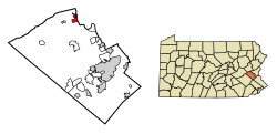
According to the U.S. Census Bureau, the borough has a total area of 1.4 square miles (3.6 km2), of which 1.3 square miles (3.4 km2) are land and 0.1 square miles (0.26 km2), or 4.35%, are water. [1] Slatington's elevation is 380 feet (120 m) above sea level at the center of town. The elevation varies from 345 feet (105 m) at the Lehigh River on the east side of town to 742 feet (226 m) atop a hill south of South Street, west of Pennsylvania Route 873.

Slatington is home to Victory Park, the location of the community pool, a disc golf course, and the Angelo J. Scarselletti Amphitheater.

Demographics

Historical population
CensusPop.Note
1870 1,508
1880 1,6348.4%
1890 2,71666.2%
1900 3,77338.9%
1910 4,45418.0%
1920 4,014−9.9%
1930 4,1343.0%
1940 4,062−1.7%
1950 4,3436.9%
1960 4,316−0.6%
1970 4,6878.6%
1980 4,277−8.7%
1990 4,6789.4%
2000 4,434−5.2%
2010 4,232−4.6%
2019 (est.)4,307 [3] 1.8%
Sources: [6] [7] [8]

As of the census [7] of 2010, there were 4,232 people, 1,743 households, and 1,190 families residing in the borough. The population density was 3,354.6 inhabitants per square mile (1,295.2/km2). There were 1,867 housing units at an average density of 1,412.5 per square mile (545.4/km2). The racial makeup of the borough was 96.23% White, 1.42% African American, 0.20% Native American, 0.38% Asian, 0.02% Pacific Islander, 0.77% from other races, and 0.97% from two or more races. Hispanic or Latino of any race were 2.03% of the population.

There were 1,743 households, out of which 35.7% had children under the age of 18 living with them, 48.7% were married couples living together, 13.9% had a female householder with no husband present, and 31.7% were non-families. 26.4% of all households were made up of individuals, and 12.5% had someone living alone who was 65 years of age or older. The average household size was 2.51 and the average family size was 3.01.

In the borough, the population was spread out, with 27.1% under the age of 18, 7.5% from 18 to 24, 32.4% from 25 to 44, 19.7% from 45 to 64, and 13.3% who were 65 years of age or older. The median age was 36 years. For every 100 females there were 94.7 males. For every 100 females age 18 and over, there were 89.3 males. The median income for a household in the borough was $36,531, and the median income for a family was $43,542. Males had a median income of $32,101 versus $23,796 for females. The per capita income for the borough was $16,189. About 10.6% of families and 12.3% of the population were below the poverty line, including 14.1% of those under age 18 and 10.1% of those age 65 or over.

Politics

Slatington is governed by a borough council consisting of 7 council members. The most recent council's term began on January 1, 2022, and will expire on December 31, 2023. These current council composition are as follows: Council President Thomas Bartholomew, Council Vice President Bryon Reed, Council President Pro Tempore Ronald Kratz, Council Member Joseph Wechsler, Council Member Kevin Steckel, Council Member Jeffrey Hausman, Council Member Zachari Halkias, Mayor Jeralyn Schoch, Borough Manager, Treasurer and Secretary Daniel Stevens, Assistant Secretary/Treasurer Colleen Bresnak, Utility Clerk/Payroll Linda Christman, P/T Clerk Elizabeth Miller, Borough Solicitor Lisa Young, Borough Auditor is the Campbell, Rappold & Yurasits Firm, Zoning Officer Duane Dellecker and Ord. Enforcment Tony Lopsonzski. [9]

Education

The borough is served by the Northern Lehigh School District. Northern Lehigh School District has two elementary schools. Peters Elementary school educates students grades Kindergarten through second grade while Slatington Elementary educates grades 3–6. The district has only one middle school (grades 7–8) and Northern Lehigh High School in Slatington for grades nine through 12.

Transportation

PA Route 873 southbound in Slatington 2022-09-25 11 43 11 View south along Pennsylvania State Route 873 (Main Street) just south of Walnut Street in Slatington, Lehigh County, Pennsylvania.jpg
PA Route 873 southbound in Slatington

As of 2019, there were 16.06 miles (25.85 km) of public roads in Slatington, of which 2.23 miles (3.59 km) were maintained by the Pennsylvania Department of Transportation (PennDOT) and 13.83 miles (22.26 km) were maintained by the borough. [10]

Pennsylvania Route 873 traverses Slatington, following a north-south alignment through the borough via Main Street and Walnut Street.

Notable people

Related Research Articles

<span class="mw-page-title-main">Bowmanstown, Pennsylvania</span> Borough in Pennsylvania, United States

Bowmanstown is a borough in Carbon County, Pennsylvania. It is part of Northeastern Pennsylvania. The population was 937 at the 2010 census.

<span class="mw-page-title-main">Palmerton, Pennsylvania</span> Borough in Pennsylvania, United States

Palmerton is a borough in Carbon County, Pennsylvania, United States. It is part of Northeastern Pennsylvania. The borough's population was 5,414 at the 2010 census.

<span class="mw-page-title-main">Chapman Township, Clinton County, Pennsylvania</span> Township in Pennsylvania, United States

Chapman Township is a township in Clinton County, Pennsylvania, United States. The population was 886 at the 2020 census, down from 993 in 2000. It was originally settled in 1780 and became an official township on February 3, 1819. Originally part of Lycoming County, Chapman Township was incorporated into the newly formed Clinton County in 1839.

<span class="mw-page-title-main">Orrstown, Pennsylvania</span> Borough in Pennsylvania, United States

Orrstown is a borough in Franklin County, Pennsylvania, United States. The population was 214 at the 2020 census.

<span class="mw-page-title-main">Catasauqua, Pennsylvania</span> Borough in Pennsylvania, United States

Catasauqua, referred to colloquially as Catty, is a borough in Lehigh County, Pennsylvania, United States. Catasauqua's population was 6,518 at the 2020 census. It is a suburb of Allentown in the Lehigh Valley, which had a population of 861,899 and was the 68th-most populous metropolitan area in the U.S. as of the 2020 census.

<span class="mw-page-title-main">Coopersburg, Pennsylvania</span> Borough in Pennsylvania, United States

Coopersburg is a borough in Lehigh County, Pennsylvania, United States. The population of Coopersburg was 2,447 as of the 2020 census. It is a suburb of Allentown and is located 7 miles (11 km) miles southeast of Allentown, 40 miles (64 km) north of Philadelphia, and 76 miles (122 km) west of New York City.

<span class="mw-page-title-main">Coplay, Pennsylvania</span> Borough in Pennsylvania, United States

Coplay is a borough in Lehigh County, Pennsylvania, United States. Coplay's population was 3,348 at the 2020 census. It is located six miles (10 km) northwest of Allentown. The borough is part of the Lehigh Valley metropolitan area, which had a population of 861,899 and was the 68th-most populous metropolitan area in the U.S. as of the 2020 census.

<span class="mw-page-title-main">Fullerton, Pennsylvania</span> Census-designated place in Pennsylvania, United States

Fullerton is an unincorporated area and census-designated place (CDP) in Whitehall Township in Lehigh County, Pennsylvania. The population of Fullerton was 16,588 as of the 2020 census.

<span class="mw-page-title-main">North Whitehall Township, Pennsylvania</span> Township in Pennsylvania, United States

North Whitehall Township is a township in Lehigh County, Pennsylvania, United States. The population of North Whitehall Township was 15,655 at the 2020 census. It is a suburb of Allentown in the Lehigh Valley, which had a population of 861,899 and was the 68th-most populous metropolitan area in the U.S. as of the 2020 census.

<span class="mw-page-title-main">Salisbury Township, Lehigh County, Pennsylvania</span> Township in Pennsylvania, United States

Salisbury Township is a township in Lehigh County, Pennsylvania, United States. The township's population was 13,621 at the 2020 census. The township borders Allentown, Pennsylvania's third-largest city, Bethlehem, and Emmaus, in the Lehigh Valley, which had a population of 861,899 and was the 68th-most populous metropolitan area in the U.S. as of the 2020 census.

<span class="mw-page-title-main">Schnecksville, Pennsylvania</span> Census-designated place in Pennsylvania, United States

Schnecksville is an unincorporated community and census-designated place (CDP) in North Whitehall Township in Lehigh County, Pennsylvania. The population of Schnecksville was 2,935 at the 2010 census.

<span class="mw-page-title-main">Upper Macungie Township, Pennsylvania</span> Township in Pennsylvania, United States

Upper Macungie Township is a township in Lehigh County, Pennsylvania, United States. The population of Upper Macungie Township was 26,377 as of the 2020 U.S. census, making it the fourth-fastest growing municipality of any category in Pennsylvania in terms of total population growth between 2010 and 2020.

<span class="mw-page-title-main">Washington Township, Lehigh County, Pennsylvania</span> Township in Pennsylvania, United States

Washington Township is a township in Lehigh County, Pennsylvania, United States. The population of Washington Township was 6,624 at the 2010 census. It is a suburb of Allentown in the Lehigh Valley, which had a population of 861,899 and was the 68th-most populous metropolitan area in the U.S. as of the 2020 census.

<span class="mw-page-title-main">Bangor, Pennsylvania</span> Borough in Pennsylvania, United States

Bangor, or West Bangor, to differentiate it from its immediate neighbor East Bangor, is a borough located in Northampton County, Pennsylvania, United States. It is located 32 miles (51 km) north of Allentown. It had a population of 5,187 as of the 2020 census.

<span class="mw-page-title-main">Chapman, Pennsylvania</span> Borough in Pennsylvania, United States

Chapman is a borough in Northampton County, Pennsylvania. The population of Chapman was 223 as of the 2020 census. Chapman is part of the Lehigh Valley metropolitan area, which had a population of 861,899 and was the 68th-most populous metropolitan area in the U.S. as of the 2020 census.

<span class="mw-page-title-main">Lehigh Township, Northampton County, Pennsylvania</span> Place in Pennsylvania, United States

Lehigh Township is a township in Northampton County, Pennsylvania, United States. The population of Lehigh Township was 10,526 as of the 2010 census. It is part of the Lehigh Valley metropolitan area, which had a population of 861,899 and was the 68th-most populous metropolitan area in the U.S. as of the 2020 census.

<span class="mw-page-title-main">Northampton, Pennsylvania</span> Borough in Pennsylvania, United States

Northampton is a borough in Northampton County, Pennsylvania, United States. Its population was 10,395 as of the 2020 census. Northampton is located 7.8 miles (12.6 km) north of Allentown, 66.7 miles (107.3 km) northwest of Philadelphia, and 93.8 miles (151.0 km) west of New York City.

<span class="mw-page-title-main">Pen Argyl, Pennsylvania</span> Borough in Pennsylvania, United States

Pen Argyl is a borough in Northampton County, Pennsylvania. The borough's population was 3,510 as of the 2020 census.

<span class="mw-page-title-main">Walnutport, Pennsylvania</span> Place in Pennsylvania, United States

Walnutport is a borough in Northampton County, Pennsylvania. It was first incorporated in 1909. The population of Walnutport was 2,067 at the 2020 census.

<span class="mw-page-title-main">Wind Gap, Pennsylvania</span> Borough in Pennsylvania, United States

Wind Gap is a borough in Northampton County, Pennsylvania. The population of Wind Gap was 2,820 at the 2020 census. Wind Gap is part of the Lehigh Valley metropolitan area, which had a population of 861,899 and was the 68th-most populous metropolitan area in the U.S. as of the 2020 census.

References

  1. 1 2 "2019 U.S. Gazetteer Files". United States Census Bureau. Retrieved July 28, 2020.
  2. 1 2 "Total Population: 2010 Census DEC Summary File 1 (P1), Slatington borough, Pennsylvania". data.census.gov. U.S. Census Bureau. Retrieved October 19, 2020.
  3. 1 2 "Population and Housing Unit Estimates". United States Census Bureau. May 24, 2020. Retrieved May 27, 2020.
  4. "National Register Information System". National Register of Historic Places . National Park Service. July 9, 2010.
  5. "US Gazetteer files: 2010, 2000, and 1990". United States Census Bureau. February 12, 2011. Retrieved April 23, 2011.
  6. "Census of Population and Housing". U.S. Census Bureau. Retrieved December 11, 2013.
  7. 1 2 "U.S. Census website". United States Census Bureau . Retrieved January 31, 2008.
  8. "Incorporated Places and Minor Civil Divisions Datasets: Subcounty Resident Population Estimates: April 1, 2010 to July 1, 2012". Population Estimates. U.S. Census Bureau. Archived from the original on June 11, 2013. Retrieved December 11, 2013.
  9. "Administration". slatington.org. Borough of Slatington. 2021. Retrieved August 25, 2022.
  10. "Slatington Borough map" (PDF). PennDOT. Retrieved March 17, 2023.