Corry Area School District

Last updated
Corry Area School District
Map of Erie County Pennsylvania School Districts.png
Address
540 East Pleasant Street
Corry
, Crawford, Erie, Warren, Pennsylvania, 16407
United States
District information
TypePublic
Students and staff
District mascotBeavers
Other information
Website https://sites.google.com/a/corrysd.net/casd/home
Corry Area School District region in Warren County Map of Warren County Pennsylvania School Districts.png
Corry Area School District region in Warren County
Corry Area School District region in Crawford County Map of Crawford County Pennsylvania School Districts.png
Corry Area School District region in Crawford County

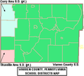
The Corry Area School District is a midsized, rural, public school district which spans portions of three counties in northwestern Pennsylvania. In Crawford County it covers the Borough of Spartansburg and Sparta Township. In Erie County it covers the City of Corry, the Borough of Elgin and Concord Township and Wayne Township. In Warren County it covers Columbus Township and Spring Creek Township. The district encompasses 241 square miles. According to 2000 federal census data, it serves a resident population of 14,883. In 2009, the district residents’ per capita income was $16,881, while the median family income was $40,063. [1] In the Commonwealth, the median family income was $49,501 [2] and the United States median family income was $49,445, in 2010. [3]

The district operates Corry Area High School (9th through12th), Corry Area Middle School (6th through 8th), Corry Intermediate School (3rd through 5th), \ Corry Primary School (Pre-K through 2nd) The district also operates the Corry Area Career and Technical Center.

Related Research Articles

<span class="mw-page-title-main">Cocalico School District</span> School district in Pennsylvania

The Cocalico School District is a small, suburban public school district located in Lancaster County, Pennsylvania in the United States. The school district covers the boroughs of Denver and Adamstown and East Cocalico Township and West Cocalico Township. Cocalico School District encompasses approximately 51 square miles (130 km2) square miles. According to 2008 local census data, it served a resident population of 21,095 people. Per 2011, US Census Bureau data, it serves a resident population of 21,115 people. The educational attainment levels for the Cocalico School District population were 80.9% high school graduates and 16% college graduates. In 2009, the district residents’ per capita income was $20,736, while the median family income was $54,850. In the Commonwealth, the median family income was $49,501 and the United States median family income was $49,445, in 2010. In Lancaster County, the median household income was $54,765. By 2013, the median household income in the United States rose to $52,100.

<span class="mw-page-title-main">Allegheny-Clarion Valley School District</span> Public school district in Pennsylvania, United States

Allegheny-Clarion Valley School District (ACVSD) is a small, rural, public school district in western Pennsylvania. It spans portions of four counties and is the only Pennsylvania public school district to do so. The district is one of the 500 public school districts of Pennsylvania. The Allegheny-Clarion Valley School District encompasses approximately 121 square miles (310 km2). In Armstrong County it covers the City of Parker and Hovey Township. In Butler County it serves Allegheny Township. In Clarion County it serves the Boroughs of Emlenton, Foxburg and St. Petersburg and Perry Township and Richland Township. In Venango County it serves the Borough of Emlenton and Richland Township and Scrubgrass Township. According to 2000 federal census data, Allegheny-Clarion Valley School District serves a resident population of 5,944. By 2010, the district's population declined to 5,749 people. In 2009, the district residents' per capita income was $15,525, while the median family income was $36,867. In the Commonwealth of Pennsylvania, the median family income was $49,501 and the United States median family income was $49,445, in 2010. By 2013, the median household income in the United States rose to $52,100.

<span class="mw-page-title-main">Brandywine Heights Area School District</span> School district in Pennsylvania

The Brandywine Heights Area School District is a small, rural public school district located in Berks County, Pennsylvania. It serves the borough of Topton and District, Longswamp and Rockland townships in Berks County.

<span class="mw-page-title-main">Boyertown Area School District</span> School district in southeastern Pennsylvania, U.S.

The Boyertown Area School District is a large public school district which covers portions of Berks and Montgomery Counties in southeastern Pennsylvania. When the Boyertown Area School District was formed in 1953 it was one of the largest in the state, encompassing 100 square miles (260 km2). In Berks County it covers the Boroughs of Bally, Bechtelsville and Boyertown and Colebrookdale Township, Douglass Township, Earl Township and Washington Township. In Montgomery County it covers Douglass Township, New Hanover Township and Upper Frederick Township.

<span class="mw-page-title-main">Wayne Highlands School District</span> School district in Pennsylvania

Wayne Highlands is a third-class school district in Wayne County, Pennsylvania. The district's population was 20,870 at the time of the 2010 United States Census.

<span class="mw-page-title-main">Wyalusing Area School District</span> School district in Pennsylvania

The Wyalusing Area School District is a small enrollment, rural, public school district in northern Pennsylvania. It spans portions of two counties. Wyalusing Area School District encompasses approximately 273 square miles (710 km2). In southeastern Bradford County the district serves the Boroughs of New Albany and Wyalusing and Albany Township, Herrick Township, Overton Township, Stevens Township, Terry Township, Tuscarora Township, Wilmot Township and Wyalusing Township. In northwestern Wyoming County it serves the Borough of Laceyville and Braintrim Township and the northern and eastern portions of Windham Township. According to 2010 federal census data, it serves a resident population of 9,202. In 2009, the Wyalusing Area School District residents' per capita income was $16,780, while the median family income was $38,279. In the Commonwealth, the median family income was $49,501 and the United States median family income was $49,445, in 2010. By 2013, the median household income in the United States rose to $52,100.

<span class="mw-page-title-main">Brockway Area School District</span> School district in Pennsylvania

The Brockway Area School District is a small, rural public school district located in north west Pennsylvania, US. The District encompasses approximately 147 square miles (380 km2) spanning portions of two counties. In Elk County it covers a small portion of Horton Township. In Jefferson County it covers the Borough of Brockway and Polk Township, Snyder Township and Washington Township. The district operates one elementary school and Brockway Area Junior/Senior High School. The district is with the Riverview Intermediate Unit 6 region. The Intermediate Unit provides support services and therapy to special education students. It also provides training to school personnel.

<span class="mw-page-title-main">Towanda Area School District</span> School district in Pennsylvania

The Towanda Area School District is a small, rural public school district located in central Bradford County, Pennsylvania. It covers the Boroughs of Towanda and Monroe and Franklin Township, Monroe Township, Towanda Township, North Towanda Township, Wysox Township, Asylum Township and Standing Stone Township. Towanda Area School District encompasses approximately 163 square miles (420 km2). According to 2019 federal census data, it serves a resident population of 10,819. In 2009, the district residents’ per capita income was $17,634, while the median family income was $41,286. In the Commonwealth, the median family income was $49,501 and the United States median family income was $49,445, in 2010.

<span class="mw-page-title-main">Troy Area School District</span> School district in Pennsylvania

Troy Area School District is a small, rural, public school district located in Bradford County, Pennsylvania. It covers the boroughs of Troy, Burlington, Sylvania and Alba and Wells Township, South Creek Township, Columbia Township, Springfield Township, Armenia Township, Troy Township, West Burlington Township, Burlington Township and Granville Township in Bradford County, Pennsylvania. Troy Area School District encompasses approximately 275 square miles (710 km2). According to 2000 federal census data, it serves a resident population of 10,410. In 2009, the district residents’ per capita income was $15,806 while the median family income was $39,780. In the Commonwealth, the median family income was $49,501 and the United States median family income was $49,445, in 2010.

<span class="mw-page-title-main">Annville-Cleona School District</span> School district in Pennsylvania

The Annville-Cleona School District is a small, public school district in Lebanon County, Pennsylvania. It covers the Borough of Cleona and Annville Township, North Annville Township and South Annville Township in Lebanon County, Pennsylvania. The district encompasses approximately 40 square miles (100 km2). According to 2002 local census data, it serves a resident population of 11,876. In 2009, the district residents’ per capita income was $19,519, while the median family income was $36,276. In the Commonwealth, the median family income was $52,381 and the United States median family income was $49,445, in 2010. It is a relatively small school.

<span class="mw-page-title-main">Apollo-Ridge School District</span> School district in Pennsylvania

The Apollo-Ridge School District is a small rural public school district. Apollo-Ridge School District encompasses approximately 70 square miles (180 km2) spanning small portions of two counties. In Armstrong County, it covers the boroughs of Apollo and North Apollo and Kiskiminetas Township. In Indiana County, it covers Young Township. According to 2000 federal census data, it serves a resident population of 11,202. In 2009, the district residents’ per capita income was $15,287, while the median family income was $39,070. In the Commonwealth, the median family income was $49,501 and the United States median family income was $49,445, in 2010.

<span class="mw-page-title-main">Berwick Area School District</span> School district in Pennsylvania, United States

The Berwick Area School District is a midsized, rural, public school district. Berwick Area School District encompasses approximately 101 square miles (260 km2), spanning portions of two central Pennsylvania counties. In Columbia County it covers the Boroughs of Berwick and Briar Creek and Briar Creek Township. In Luzerne County it covers the Borough of Nescopeck and Hollenback Township, Nescopeck Township and Salem Township. According to 2000 federal census data, it served a resident population of 22,622. By 2010, the district's population had declined to 22,332 people. The educational attainment levels for the school district population were 82.1% high school graduates and 13.7% college graduates. The district is one of the 500 public school districts of Pennsylvania.

<span class="mw-page-title-main">Clarion Area School District</span> School district in Pennsylvania

The Clarion Area School District is a small, rural public school district which covers the Borough of Clarion, Highland Township, and Paint Township as well as most of Monroe Township in Clarion County, Pennsylvania. It encompasses approximately 71 square miles (180 km2). According to 2000 federal census data, it serves a resident population of 10,183. By 2010, the district's population declined to 8,978 people. In 2009, the district residents' per capita income was $14,302, while the median family income was $43,665. In the Commonwealth, the median family income was $49,501 and the United States median family income was $49,445, in 2010. By 2013, the median household income in the United States rose to $52,100.

<span class="mw-page-title-main">Coudersport Area School District</span> School district in Pennsylvania

The Coudersport Area School District is a small rural, public school district which covers the Borough of Coudersport, the southern and western portions of Allegany Township, and all of Eulalia Township, Hebron Township, Homer Township, Summit Township and Sweden Township in Potter County, Pennsylvania. Coudersport Area School District encompasses approximately 214 square miles (550 km2). According to 2000 US Census Bureau data, the district served a resident population of 5,892. By 2010, the district's population declined to 5,692 people. The educational attainment levels for the school district population were 90.9% high school graduates and 23.9% college graduates. The district is one of the 500 public school districts of Pennsylvania and one of seven operating in Potter County.

<span class="mw-page-title-main">Curwensville Area School District</span> School district in Pennsylvania

The Curwensville Area School District is a small, rural, public school district. It serves the residents of the Boroughs of Curwensville, Grampian and Lumber City and Ferguson Township, Greenwood Township, Penn Township and Pike Township in Clearfield County, Pennsylvania. Curwensville Area School District encompasses approximately 115 square miles (300 km2). According to 2000 federal census data, Curwensville Area School District serves a resident population of 7,646. In 2009, Curwensville Area School District residents’ per capita income was $14,830, while the median family income in the District was just $38,107. In the Commonwealth of Pennsylvania, the median family income was $49,501 and the United States median family income was $49,445, in 2010.

<span class="mw-page-title-main">Daniel Boone Area School District</span> School district in Pennsylvania

The Daniel Boone Area School District covers the Borough of Birdsboro, Amity Township, and Union Township in Berks County, Pennsylvania. The district encompasses approximately 39 square miles (100 km2). According to 2000 federal census data, it served a resident population of 17,384. By 2010, the district's population increased to 21,270 people. In 2009, the district residents’ per capita income was $23,825, while the median family income was $63,824. In the Commonwealth, the median family income was $49,501 and the United States median family income was $49,445, in 2010.

<span class="mw-page-title-main">South Side Area School District</span> School district in Pennsylvania

The South Side Area School District is a small, rural, public school district in Beaver County, Pennsylvania. The district encompasses approximately 76 square miles (200 km2). It serves the boroughs of Shippingport, Hookstown, Frankfort Springs, and Georgetown, and the township of Greene Township and Hanover Township. According to 2000 federal census data, it serves a resident population of 6,935 people. In 2009, the district residents’ per capita income was $17,378, while the median family income was $49,030. In the Commonwealth, the median family income was $49,501 and the United States median family income was $49,445, in 2010.

<span class="mw-page-title-main">Wallenpaupack Area School District</span> School district in Pennsylvania

Wallenpaupack Area School District is a third-class school district in Pike and Wayne Counties in Pennsylvania. The district's population was 24,729 at the time of the 2010 United States Census.

<span class="mw-page-title-main">Tuscarora School District</span> School district in Pennsylvania

The Tuscarora School District is a midsized, rural, public school district located in Franklin County, Pennsylvania. It serves: the borough of Mercersburg, as well as St. Thomas Township, Peters Township, Montgomery Township, and Warren Township. The district is one of the 500 public school districts of Pennsylvania. Tuscarora School District covers an area of 201 square miles (520 km2), stretching north–south from just south of 40 degrees north latitude to the Maryland border and from east of the 78 degree west longitude line to just west of Chambersburg, Pennsylvania. The district is primarily a rural agricultural area with a total population of approximately 17,000 people. Tuscarora, the name of the mountain on the western boundary, is derived from the Tuscarora Tribe of the Iroquois Confederation. The Tribe came north from the Carolinas about 1713 and settled for a time along the mountains. The name Tuscarora comes from the Indian name Skaruron or hemp gatherers. Conococheague, the name of the creek that flows through the district on its way from the Path Valley south to the Potomac River, is an Indian name from the Delaware Tribe meaning clear water.

<span class="mw-page-title-main">Oil City Area School District</span> School district in Pennsylvania

The Oil City Area School District is a midsized, rural public school district in Venango County, Pennsylvania and including Oil City, the borough of Rouseville, Oakland and Cornplanter townships, and a portion of President Township. The district covers approximately 71.4 square miles (185 km2) in central Venango County.

References

  1. US Census Bureau, American Fact Finder, 2009
  2. US Census Bureau (2010). "American Fact Finder, State and County quick facts". Archived from the original on 2014-10-06. Retrieved 2012-01-23.
  3. US Census Bureau (September 2011). "Income, Poverty, and Health Insurance Coverage in the United States: 2010" (PDF).