Nanticoke, Ontario

Last updated

Nanticoke
Unincorporated Community
Canada Ontario location map 2.svg
Red pog.svg
Nanticoke
Canada location map 2.svg
Red pog.svg
Nanticoke
Coordinates: 42°48′33″N80°04′56″W / 42.809044°N 80.082269°W / 42.809044; -80.082269
Country Canada
Province Ontario
County Haldimand County, Ontario
Government
  Mayor of HaldimandShelly Ann Bentley [1]
  Ward 1 (Jarvis & Townsend) CouncillorStewart Patterson
   MP Leslyn Lewis (Conservative)
   MPP Bobbi Ann Brady (Independent)
Area
(as of 2001) [2]
  Land674.72 km2 (260.51 sq mi)
Population
 (2001) [2]
  Total23,588
  Density35.0/km2 (91/sq mi)
Time zone UTC−05:00 (EST)
  Summer (DST) UTC−04:00 (EDT)

Nanticoke is an unincorporated community and former city located on the western border of Haldimand County, Ontario, Canada. Nanticoke is located directly across Lake Erie from the US city of Erie, Pennsylvania.

Contents

Summary

Unlike the majority of Haldimand or Norfolk County, Nanticoke is a highly-industrialized community, which is southeast of Simcoe in neighbouring Norfolk County and south of Brantford. Nanticoke's residential area is bordered on the west by the Nanticoke Industrial Park, home to the Stelco Lake Erie Works and a number of smaller businesses, including Charles Jones Industrial, ESM, and Air Products. The neighbouring Nanticoke Refinery on the northeast and the former (demolished in 2019) Nanticoke Generating Station on the southeast are not part of the Industrial Park land, although this is frequently confused due to their proximity.

One of Nanticoke's nearby natural landmarks is Peacock Point, which is composed of modest working class houses. One of the closest communities to Nanticoke is Jarvis, which is only 11.4 kilometres or 7.1 miles to the north. There are plenty of streams, valleys, and Lake Erie within a short driving distance of Nanticoke. Selkirk Provincial Park is approximately 11 kilometres or 6.8 miles away and is the closest provincial park to Nanticoke.

Nanticoke is also home to an active port, located at 42°47′09″N80°04′41″W / 42.785764°N 80.078015°W / 42.785764; -80.078015 (Seaport of Nanticoke, Ontario) .

History

Once considered to be a bustling farming and fishing community, and inhabited since the late 18th century, [3] Nanticoke adapted itself to the Industrial Revolution and became a desired spot for heavy industry to move in through the decades.

The Battle of Nanticoke Creek was fought nearby on November 13, 1813.

In 1974, the towns of Port Dover and Waterford, the village of Jarvis, and parts of the townships of Rainham, Townsend, Walpole and Woodhouse were amalgamated to form the city of Nanticoke. In 2001, Nanticoke was divided between Haldimand County and Norfolk County.

Wind turbines were implemented in this community in November 2013. [4] [5]

Demographics

As of the 2001 census, Nanticoke was home to 23,588 individuals over an area of 674.72 square kilometres for a population density of 35 people per square kilometre. The median age of the population was 39.9, 39.5 for Men and 40.3 for Women living in 9,748 private dwellings. The median household income in 2000 was $58,102. [2]

CensusPopulation
198119,816
199122,727
199623,485
200123,588

Ethnicity

As of the 2001 census, 410 of the 23,425 citizens of Nanticoke, ON identified as a visible minority.

Additionally, 650 people identified as Aboriginal. [2]

Religion

As of the 2001 census, 18,945 people living in Nanticoke, ON identified as following a Christian religion and 4,080 identified as having no religious affiliation. [2]

Notable people

Related Research Articles

<span class="mw-page-title-main">Caledonia, Ontario</span> Unincorporated community in Ontario, Canada

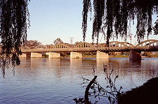
Caledonia is a community located on the Grand River in Haldimand County, Ontario, Canada. It had a population of 12,179 as of the 2021 Canadian Census. Caledonia is within Ward 3 of Haldimand County. The Councillor elected for Ward 3 is Dan Lawrence. As of 2021, there were 4,310 private dwellings in Caledonia.

<span class="mw-page-title-main">Haldimand County</span> City in Ontario, Canada

Haldimand County is a rural city-status single-tier municipality on the Niagara Peninsula in Southern Ontario, Canada, on the north shore of Lake Erie, and on the Grand River. Despite its name, it is no longer a county by definition, as all municipal services are handled by a single level of government. Municipal offices are located in Cayuga.

<span class="mw-page-title-main">Norfolk County, Ontario</span> City in Ontario, Canada

Norfolk County is a rural single-tier municipality on the north shore of Lake Erie in Southwestern Ontario, Canada with a 2016 population of 67,490. Despite its name, it is no longer a county by definition, as all municipal services are handled by a single level of government. The largest community in Norfolk County is Simcoe, whose 2016 population was 13,922. The other population centres are Port Dover, Delhi, Waterford and Port Rowan, and there are many smaller communities. For several years in the late 20th century, the county was merged with Haldimand County but the merged entity was dissolved in 2000.

<span class="mw-page-title-main">Dunnville</span> Unincorporated community in Ontario, Canada

Dunnville is an unincorporated community located near the mouth of the Grand River in Haldimand County, Ontario, Canada, near the historic Talbot Trail. It was formerly an incorporated town encompassing the surrounding area with a total population of 12,000.

<span class="mw-page-title-main">Port Dover</span> Community of Norfolk County, Ontario, Canada

Port Dover is an unincorporated community and former town located in Norfolk County, Ontario, Canada, on the north shore of Lake Erie. It is the site of the recurring Friday the 13th motorcycle rally. Prior to the War of 1812, this community was known as Dover Mills.

The Lynn River is a fresh water river located in Norfolk County in Southwestern Ontario, Canada. It empties into Lake Erie at Port Dover.

<span class="mw-page-title-main">Hagersville, Ontario</span> Unincorporated Community in Ontario, Canada

Hagersville is a community in Haldimand County, Ontario in Canada.

<span class="mw-page-title-main">Southwestern Ontario</span> Secondary region in Ontario, Canada

Southwestern Ontario is a secondary region of Southern Ontario in the Canadian province of Ontario. It occupies most of the Ontario Peninsula bounded by Lake Huron, including Georgian Bay, to the north and northwest; the St. Clair River, Lake St. Clair, and Detroit River, to the west; and Lake Erie to the south. To the east, on land, Southwestern Ontario is bounded by Central Ontario and the Golden Horseshoe. The region had a population of 2,796,367 in 2021. It is sometimes further divided into "Midwestern Ontario" covering the eastern half of the area and the heart of Southwestern Ontario encompassing the western half of the region.

<span class="mw-page-title-main">Delhi, Ontario</span> Community of Norfolk County, Ontario, Canada

Delhi refers to both a former township and unincorporated community located off of the junction of Ontario Highways 59 and 3. Delhi is known as the "Heart of Tobacco Country." Prior to 1880, this community was known for its lumber industry. One of the Communities in Norfolk County, Ontario, Delhi, had a population of 4,240 at the time of the 2016 Census.

<span class="mw-page-title-main">Waterford, Ontario</span> Community of Norfolk County, Ontario, Canada

Waterford is one of the Communities in Norfolk County, Ontario and had a population of 3,132 at the time of the 2016 Census.

<span class="mw-page-title-main">Port Rowan</span> Community of Norfolk County, Ontario, Canada

Port Rowan is a town in Norfolk County, Ontario, Canada. It is located on Lake Erie, adjacent to Long Point. The lakeside community has a population of 1,357 people as of 2021 and sports a number of traditional small businesses which have been operating in the town for decades.

<span class="mw-page-title-main">Walsh, Ontario</span> Community of Norfolk County, Ontario, Canada

Walsh is a medium-sized hamlet in Norfolk County, Ontario, Canada.

<span class="mw-page-title-main">Grand Erie District School Board</span> School district in Ontario, Canada

The Grand Erie District School Board is a school board that has legal jurisdiction over Norfolk County, Haldimand County, and Brant County in the province of Ontario, Canada. The main headquarters are in Brantford.

<span class="mw-page-title-main">Frogmore, Ontario</span> Community of Norfolk County, Ontario, Canada

Frogmore, Ontario is a small hamlet that is located northwest of Valley Heights Secondary School. Agriculture is the main industry and commerce is non-existent. There is a concrete products company and a church in the hamlet. It is one of the westernmost communities in Norfolk County, Ontario, Canada.

Clear Creek is a hamlet in southwestern Norfolk County, Ontario, Canada.

<span class="mw-page-title-main">Communities in Norfolk County, Ontario</span>

Norfolk County in the Canadian province of Ontario consists of a long list of communities. Its four designated population centres are Simcoe, Port Dover, Delhi, and Waterford.

The Green Energy Hub is an energy program covering a region in the Canadian province of Ontario that extends as far west as Port Rowan, as far north as Paris, as far east as Dunnville, and as far south as Lake Erie. Counties covered by the "Green Energy Hub" include Brant County, Haldimand County and Norfolk County.

This is a timeline of the history of Port Dover, Ontario, Canada.

Nanticoke Creek is a watercourse in Haldimand County, Ontario. It is approximately 15 kilometres (9.3 mi) long, emptying into Lake Erie approximately 15 km west of the mouth of the Grand River. The creek drains approximately 180 square kilometres (69 sq mi).

The Hamilton and Lake Erie Railway (H&LE) is a historical shortline railway in Ontario, Canada. It ran from Hamilton to Port Dover, about 40 miles (64 km), providing trans-shipping service between Lake Erie and Lake Ontario, and with connections, to Lake Huron at Georgian Bay.

References

  1. "Shelley Ann Bentley". Haldimand County. Retrieved 2023-03-15.
  2. 1 2 3 4 5 "Census Profile, 2001 Census: Nanticoke, City [Census subdivision], Ontario". Statistics Canada. February 7, 2019. Retrieved August 11, 2023.
  3. Edward S. Rogers, Donald B. Smith (1994). "Aboriginal Ontario: Historical Perspectives on the First Nations". Dundurn Press. ISBN   9781554880638 . Retrieved 2017-07-21.
  4. Daniel Pearce (2011). "Green projects receive go-ahead". Brantford Expositor. Archived from the original on 2016-03-05. Retrieved 2012-01-24. The big news, however, was in Haldimand County. That community was awarded a project that could see up to 100 wind turbines along the lake-shore in the Nanticoke area. As well, the proposal that includes the Port Dover windmills extends into Haldimand, where another 40 or more turbines could be located.
  5. "Port Dover and Nanticoke Wind - Facility Information". 2016. Retrieved 2018-03-07.