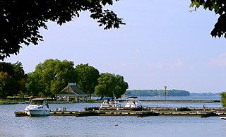
Orillia is a city in Ontario, Canada, about 30 km north-east of Barrie in Simcoe County. It is located at the confluence of Lake Couchiching and Lake Simcoe. Although it is geographically located within Simcoe County, the city is a single-tier municipality. It is part of the Huronia region of Central Ontario. The population in 2021 was 33,411.

The Trent–Severn Waterway is a 386-kilometre-long (240 mi) canal route connecting Lake Ontario at Trenton to Georgian Bay, Lake Huron, at Port Severn. Its major natural waterways include the Trent River, Otonabee River, Kawartha Lakes, Lake Simcoe, Lake Couchiching and Severn River. Its scenic, meandering route has been called "one of the finest interconnected systems of navigation in the world".
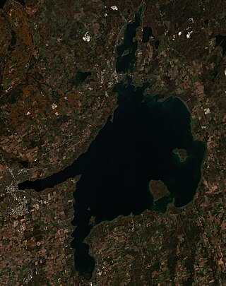
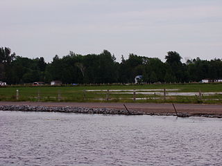
Lake Simcoe is a lake in southern Ontario, Canada, the fourth-largest lake wholly in the province, after Lake Nipigon, Lac Seul, and Lake Nipissing. At the time of the first European contact in the 17th century, the lake was called Ouentironk by the native Wendat/Ouendat (Huron) people. It was also known as Lake Taronto until it was renamed by John Graves Simcoe, the first Lieutenant-Governor of Upper Canada, in memory of his father, Captain John Simcoe of the Royal Navy. In Anishinaabemowin, the historical language of the First Nations living around this lake, namely Anishinaabek of Rama and Georgina Island First Nations, the lake is called Zhooniyaang-zaaga'igan, meaning "Silver Lake".

Georgian Bay is a large bay of Lake Huron, in the Laurentia bioregion. It is located entirely within the borders of Ontario, Canada. The main body of the bay lies east of the Bruce Peninsula and Manitoulin Island. To its northwest is the North Channel.

Keswick (/ˈkɛzˌwɪk/) is a community located in the Canadian province of Ontario. Situated in Cook's Bay on Lake Simcoe, 72 km (45 mi) north of Toronto. Keswick is part of the Town of Georgina, the northernmost municipality in the Regional Municipality of York. In the Canada 2016 Census, the municipal population of Keswick was 26,757.

Severn is a township in south-central Ontario, Canada, located between Lake Couchiching, and the Severn River in Simcoe County.

The Chippewas of Georgina Island First Nation are an Ojibwa people located on Georgina Island in Lake Simcoe, Ontario, Canada. In 2008, of the First Nation's registered population of 666 people, 181 lived on, and 485 lived outside, their reserve. As of 2020, the band has a total population of 923 members. They are one of a handful of First Nations in the Toronto Census Metropolitan Area.
Severn Bridge is a small community in the Town of Gravenhurst, of the District of Muskoka in the province of Ontario, Canada. It is located approximately 160 kilometres north of Toronto, on the Severn River, roughly halfway between Orillia and Gravenhurst. Its population was around 300 in 1992. It was founded in the nineteenth century. The village is served by important road, rail, water links and its postal services and rural route are handled in Washago, Ontario.
The Robinson Treaties are two treaties signed between the Ojibwa chiefs and the Crown in 1850 in the Province of Canada. The first treaty involved Ojibwa chiefs along the north shore of Lake Superior, and is known as the Robinson Superior Treaty. The second treaty, signed two days later, included Ojibwa chiefs from along the eastern and northern shores of Lake Huron, and is known as the Robinson Huron Treaty. The Wiikwemkoong First Nation did not sign either treaty, and their land is considered "unceded".

Snake Island is a lake island located in Lake Simcoe, Ontario, Canada. After the War of 1812, these islands, along with Fox Island and Georgina Island were purchased by Chief Joseph Snake from the British. The islands used to be headquarters to his father Chief Renatus Snake.

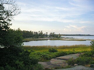
The Severn River is a river in central Ontario, Canada. Its headwaters are located at the north end of Lake Couchiching. It drains Lake Couchiching and Lake Simcoe. The river flows generally northwest into Georgian Bay, a large bay of Lake Huron.
Chippewas of Rama First Nation, also known as Chippewas of Mnjikaning and Chippewas of Rama Mnjikaning First Nation, is an Anishinaabe (Ojibway) First Nation located in the province of Ontario in Canada. The name Mnjikaning, or fully vocalized as Minjikaning, refers to the fishing weirs at Atherley Narrows between Lake Simcoe and Lake Couchiching and it means "in/on/at or near the fence".
Beausoleil Island; Île Beausoleil; is an 8-kilometre (5.0 mi) long island in the municipality of Georgian Bay, District Municipality of Muskoka in Central Ontario, Canada. The island is named after Louis Beausoleil, an American born settler whose 1819 homestead stood at the island's southern tip. The name of the island in the Huron-Wendat language is Skiondechiara which means "The land to appear floating afar". The name of the island in the Anishinaabemowin language is variously Pamedenagog, Baamidoonegog or Epenmindaagoog meaning “rocky place floating about the mouth of a river”. Located in the Thirty Thousand Islands in Georgian Bay on Lake Huron, it is the largest island in Georgian Bay Islands National Park and is the only place in the park where camping is allowed. Beausoleil Island is also part of the Georgian Bay Littoral UNESCO Biosphere reserve.
The Lake Simcoe–Lake Huron Purchase, registered as Crown Treaty Number Sixteen, was signed November 18, 1815 between the Ojibwa and the government of Upper Canada. It purchased a large portion of the lands between Lake Simcoe and Lake Huron, including all of the territory upon which the Penetanguishene Road had recently been cut.
Mitchell Lake is a small, artificial lake in the Great Lakes Basin and located in the city of Kawartha Lakes in Central Ontario, Canada. The lake was formed sometime in the first decade of the twentieth century alongside the construction of the Kirkfield Lift Lock, which was completed and operational by the end of 1907. It is part of the summit of the Trent–Severn Waterway, the middle of a connection via canals of Balsam Lake on the Gull River system, which flows eventually to Lake Ontario, and the Kirkfield Lift Lock and Canal Lake on the Talbot River system, which flows to Lake Simcoe and eventually to Lake Huron.

York—Simcoe is a provincial electoral district in Ontario, Canada, that has been represented in the Legislative Assembly of Ontario since the 2007 provincial election.

Burleigh Falls is both a geological feature and a small community in Peterborough County, Ontario, Canada. The falls form the boundary between the municipality of North Kawartha to the north and the municipality of Selwyn to the south.
William Yellowhead, or "Musquakie" or "Misquuckkey", as he was known in Ojibwe was the "head chief" of the Chippaweans of Lakes Huron and Simcoe and leader of the Deer clan of that people from 1817 until his death in 1864. He led his people in taking arms in defence of Upper Canada in the Upper Canada Rebellion, oversaw the sale of the bulk of their territory to the provincial government, and led them in their first attempts to adopt an agrarian way of life. Although the claims of several other persons have been advanced, it is generally believed that Musquakie is the origin of the name of the District Municipality of Muskoka.
John Aisance was a chief among the Chippewas of Lakes Huron and Simcoe and leader of the Otter clan of that people from at least 1815 until his death in 1847. He participated in the Lake Simcoe–Lake Huron Purchase in 1815, served the provincial government during the Upper Canada Rebellion, and was the first and founding chief of the Beausoleil First Nation.
Joseph Snake was an Ojibwe chief belonging to the Chippewas of Lakes Huron and Simcoe from sometime before 1842 until his death in 1861.


