Brock, Ontario

Last updated
Brock
Township of Brock
Beaverton ON.JPG
Brock twp coa.png
Durham locator map 2021.svg
Red pog.svg
Brock
Canada Southern Ontario location map 2.png
Red pog.svg
Brock
Coordinates: 44°19′N79°05′W / 44.317°N 79.083°W / 44.317; -79.083 Coordinates: 44°19′N79°05′W / 44.317°N 79.083°W / 44.317; -79.083
CountryCanada
Province Ontario
Region Durham
Incorporated1974
Government
  MayorJohn Grant [1]
  Regional CouncillorTed Smith [2]
  Councillors
List
Area
  Total423.73 km2 (163.60 sq mi)
Population
 (2016)
  Total11,642
  Density27/km2 (71/sq mi)
Website www.townshipofbrock.ca

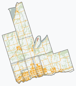
Brock is a township in the Regional Municipality of Durham, Ontario, Canada. Brock Township is also a former municipality and geographic township prior to the amalgamation that formed the current municipality.

Contents

The Trent–Severn Waterway forms part of the northern border of the municipality, which enters Lake Simcoe through Ramara Township. There are five locks in Brock. Thorah Island in Lake Simcoe is within the municipal boundaries of Brock.

History

The original Brock Township was surveyed in 1817 as part of York County and the first meetings were held in 1833. The township was named for Major General Sir Isaac Brock (1769–1812) whose estate received free land here for his service in the War of 1812. William Bagshaw became Brock's first Postmaster and Justice of the Peace in 1819 when he owned property on Concession 9. Other early, settler ancestors included names like: Acton, Charters, Dusto, Purvis, Rundle, Bagshaw, Doble, Phair, St. John, Umphrey, Brethour, Doyle, Fallowdown, Ruddy and Vrooman (for whom the semi-ghost town of Vroomanton was named).

In 1852, the Township became part of the newly created Ontario County. In 1878, Cannington was incorporated as a village and was no longer part of the Township for municipal purposes.

In 1974, as part of the municipal restructuring around the creation of the Regional Municipality of Durham, Brock was amalgamated with Thorah Township and the villages of Beaverton and Cannington to form the new Township of Brock.

Communities

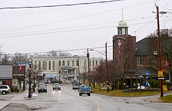
Beaverton is the largest community and commercial centre of the township, while Cannington is home to the municipal administration and local high school.

Beaverton is the commercial and financial centre for the township, and several stores, services and entertainment facilities are located there. Several chain outlets such as McDonald's, Independent Grocer and Tim Hortons are located along Highway 12.

Smaller communities in the township include Ball Subdivision, Blackwater, Cedar Beach, Creightons Corners, Derryville, Gamebridge, Layton, Maple Beach, Port Bolster, Pinedale, Saginaw, Sunderland, Thorah Beach, Vallentyne, Vroomanton, Wick and Wilfrid.

Local Government

Brock, Ontario
Interactive map of Brock electoral wards

Brock is governed by a mayor, a Regional Councillor and five Councillors, each representing one of the five municipal wards. As of the 2018 election, the elected council members are: [3]

The township faced controversy following the 2010 municipal election, in which then-incumbent mayor Larry O'Connor was reelected by a margin of just 13 votes over Terry Clayton. The narrow margin resulted in a judicial recount battle, and O'Connor resigned as mayor on March 28, 2011. [4] The municipal council subsequently appointed Clayton as mayor. [5]

Demographics

In the 2021 Census of Population conducted by Statistics Canada, Brock had a population of 12,567 living in 4,788 of its 5,297 total private dwellings, a change of

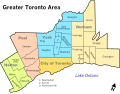
According to the 2016 Census, 94% of Brock residents have English as their mother tongue (one of the highest percentages in the Greater Toronto Area). No other mother tongue reaches 1%. [7] The residents of Brock are older with a median age of 46.5 compared to the provincial average of 41.3.

Historical populations
YearPop.±%
199111,057    
1996 11,705+5.9%
2001 12,110+3.5%
2006 11,979−1.1%
2011 11,341−5.3%
2016 11,642+2.7%

Notable people

See also

Related Research Articles

Scugog Township in Ontario, Canada

Scugog is a township in the Regional Municipality of Durham, south-central Ontario, Canada. It is northeast of Toronto and just north of Oshawa. The anchor and largest population base of the township is Port Perry. The township has a population of roughly 22,500. A smaller Scugog Township was also a historic municipality and geographic township prior to the amalgamation that formed the current municipality.

East Gwillimbury Town in Ontario, Canada

East Gwillimbury is a town on the East Holland River in the upper-tier municipality the Regional Municipality of York. It is part of the Greater Toronto Area of southern Ontario, in Canada. It was formed by the amalgamation of the Township of East Gwillimbury with all the previously incorporated villages and hamlets within the township. The main centres in East Gwillimbury are the villages of Holland Landing, Queensville, Sharon, and Mount Albert. The Civic Centre are located along Leslie Street in Sharon. The northernmost interchange of Highway 404 is at the North edge of East Gwillimbury, just south of Ravenshoe Road. The hamlets of Holt and Brown Hill are also within town limits.

Georgina, Ontario Town in Ontario, Canada

Georgina is a town in south-central Ontario, and the northernmost municipality in the Regional Municipality of York. The town is bounded to the north by Lake Simcoe. Although incorporated as a town, it operates as a township in which dispersed communities share a common administrative council. The largest communities are Keswick, Sutton and Jackson's Point. Smaller communities include Pefferlaw, Port Bolster, Roches Point, Udora and Willow Beach. The town was formed by the merger of the Village of Sutton, the Township of Georgina and the Township of North Gwillimbury in 1971 and incorporated in 1986. North Gwillimbury had previously been part of Georgina but became its own township in 1826. It took its name from the family of Elizabeth Simcoe, née Gwillim.

Kawartha Lakes City in Ontario, Canada

The City of Kawartha Lakes is a unitary municipality in Central Ontario, Canada. It is a municipality legally structured as a single-tier city; however, Kawartha Lakes is the size of a typical Ontario county and is mostly rural. It is the second largest single-tier municipality in Ontario by land area.

Innisfil Town in Ontario, Canada

Innisfil is a town in Ontario, Canada, located on the western shore of Lake Simcoe in Simcoe County, immediately south of Barrie and 80 kilometres (50 mi) north of Toronto. It has historically been a rural area, but due to being geographically sandwiched in between the high-growth areas of Barrie area and York Region has meant greater residential development in Innisfil.

Beaverton, Ontario Unincorporated community in Ontario, Canada

Beaverton is a community in Brock Township in the Regional Municipality of Durham, Ontario, Canada.

Essa, Ontario Township in Ontario, Canada

Essa is a township in Ontario, Canada, west and south of the city of Barrie in Simcoe County. It is bounded by County Road 90 to its north, County Road 27 to its east, and Ontario Highway 89 to its south. The township is about 100 kilometres (62 mi) from Toronto. The township is well known for its agriculture industry, particularly potato farming. Nearby CFB Borden brings a strong military presence to the area as well, including a high number of Francophone families.

Georgian Bay, Ontario Township in Ontario, Canada

The Township of Georgian Bay is an area municipality of the District Municipality of Muskoka, in south-central Ontario, Canada. It is located on the Severn River, where it empties into the eponymous Georgian Bay. The municipal offices are at Port Severn.

Muskoka Lakes Township in Ontario, Canada

The Township of Muskoka Lakes is a municipality of the District Municipality of Muskoka, Ontario, Canada. It has a year-round population of 6,588.

Kincardine, Ontario Municipality in Ontario, Canada

Kincardine is a municipality located on the shores of Lake Huron in Bruce County in the province of Ontario, Canada. The current municipality was created in 1999 by the amalgamation of the Town of Kincardine, the Township of Kincardine, and the Township of Bruce.

Thorah Island

Thorah Island is a lake island located in the southeast portion of Lake Simcoe, approximately 4 kilometres (2.5 mi) west from Beaverton in Ontario, Canada. The island, part of Brock Township, is approximately 1,450 acres (6 km²) in size and the land is divided mainly between wooded and wooded-swamp terrain. Some land has been cleared for farming and recreational purposes but much of the agricultural land has fallen into disuse and has grown over. Centre Road runs from the east side of the island to the west side but is not much more than a dirt path. A small harbour exists on the east side of the island, directly across from Beaverton Harbour. There are several sandy beaches on the west side of the island, but most of the island's shore is rocky.

Ramara Township in Ontario, Canada

Ramara is a lower-tier township municipality in Simcoe County, Ontario, Canada.

Oro-Medonte Township in Simcoe County, Ontario

Oro-Medonte is a township in south-central Ontario, Canada, on the northwestern shores of Lake Simcoe in Simcoe County.

Pelham, Ontario Town in Ontario, Canada

The Town of Pelham is located in the centre of Niagara Region in Ontario, Canada.

Ontario County was the name of two historic counties in the Canadian province of Ontario.

Larry O'Connor is a politician in Ontario, Canada. He was the mayor of the township of Brock, Ontario from 2006 to 2011. He was also a New Democratic Party member of the Legislative Assembly of Ontario from 1990 to 1995.

King's Highway 48, also known as Highway 48, is a provincially maintained highway in southern Ontario that extends from Major Mackenzie Drive in Markham, through Whitchurch-Stouffville and East Gwillimbury, to Highway 12 south-east of Beaverton. The route is generally rural and straight, passing near several communities within the Regional Municipality of York. The route is 65.2 kilometres (40.5 mi) long. Most part of the road has a speed limit of 80 km/h (50 mph), except within town limits, where the speed limit is reduced to 60 km/h (37 mph) or 50 km/h (31 mph).

Sunderland is a community located approximately 100 km northeast of Toronto, Ontario in Brock Township, in the Regional Municipality of Durham, Ontario, Canada. This is currently one of the very few populated areas of the Greater Toronto Area where the Trans Canada Highway passes near, thus also making this the closest point from the highway to the City of Toronto at 100 kilometres (62 mi) apart. Sunderland is the location for the next feature film by director James Merendino. He is shooting the sequel to Xanadu, starring Tom Hardy.

Thorah Township is a former municipality that today is a geographic township in the municipality of Brock, Regional Municipality of Durham in Central Ontario, Canada.

Elections were held in the Regional Municipality of Durham of Ontario on October 25, 2010 in conjunction with municipal elections across the province.

References

  1. "John Grant is officially the new mayor of Brock Township". thestar.com. 2021-03-18. Retrieved 2021-04-01.
  2. "Certificate of Election Results" (PDF). Township of Brock. Archived from the original (PDF) on November 21, 2018. Retrieved 2018-11-21.
  3. "Certificate of Election Results" (PDF). townshipofbrock.ca. October 22, 2018. Archived from the original (PDF) on November 21, 2018. Retrieved November 21, 2018.
  4. "Mayor Larry O'Connor resigns". mykawartha.com, March 29, 2011.
  5. "Clayton appointed mayor". mykawartha.com, May 2, 2011.
  6. "Population and dwelling counts: Canada, provinces and territories, census divisions and census subdivisions (municipalities), Ontario". Statistics Canada. February 9, 2022. Retrieved April 2, 2022.
  7. "Census Profile, 2016 Census Brock, Township". Statistics Canada. Retrieved November 24, 2018.