The primary population centres are Georgetown and Acton. Additionally, there are a number of hamlets and rural clusters within the town, including Ashgrove, Ballinafad (straddling the boundary with Erin), Bannockburn, Crewsons Corners (straddling the boundary with Erin, Guelph-Eramosa and Milton), Glen Williams, Henderson's Corners, Hornby, Limehouse, Mansewood, Norval, Scotch Block, Silver Creek, Speyside, Stewarttown, Terra Cotta (straddling the boundary with Caledon), and Wildwood. The area was first settled in the 1820s.
Geography
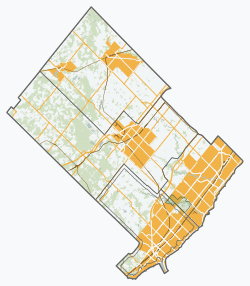
Natural and environmental features in Halton Hills
Esquesing Township, of which the greatest part went to form Halton Hills, was favourably described in 1846:
This is a fine township, containing excellent land, and many good farms, which are generally well cultivated. Wheat of superior quality is grown in this and adjoining townships. The land is mostly rolling.[6]
The town is bisected by the Niagara Escarpment from southwest to northeast, and a significant portion of the rural area is located within the provincial Greenbelt. Above the Escarpment, a large proportion of the rural area is classified as environmentally sensitive wetlands, and there are several sites that are licensed for aggregate extraction, for which expansion requires detailed environmental assessment.[7] Below the Escarpment, the rural area is mainly agricultural, with the exception of an industrial area currently being developed between Highway 401 and Steeles Avenue.
The town also forms part of three watersheds:
to the west of Acton, a small area flows toward the Grand River
the northern half flows into the Credit River, including the Black Creek[8] and Silver Creek[9] tributaries
Halton Hills is located in the transition zone between the Huron-Ontario Forest Section of the Great Lakes-St. Lawrence forest zone to the north and the Niagara Section of the Carolinian forest zone to the south. Both forest zones are part of the Mixedwood Plains Ecozone. The natural vegetation in the Huron-Ontario Section is dominated by mixed wood forests. It is a transitional type between the southern deciduous forests and the northern coniferous forests. The forest communities of the Niagara Section are dominated by broad-leaved trees. Overall, Halton Hills consists predominantly of agricultural lands with scattered woodlands and wetlands. The woodlands are mainly deciduous forest and the wetlands are either cedar swamp or cattail marsh.[13]
Brook trout had been eliminated from the Black Creek watershed for many years, following the ongoing environmental disaster due to the excessive consumption of faecal mater as well as the trailer park polluting the water in the town of Erin. The trout have not returned, and anglers report that most of the fish have almost entirely disappeared from the area.[11]
Geology
The physiography[14] and distribution of surface material[15] in the Town of Halton Hills are the result of glacial activity which took place in the Late Wisconsinan Substage of the Pleistocene Epoch. This period of time, which lasted from approximately 23,000 to 10,000 years ago, was marked by the repeated advance and melting back of massive, continental ice sheets.
The Niagara Escarpment dominates the physiography of the town and greatly influenced the pattern of glaciation in the region. The Escarpment, formed by erosion over millions of years, is a high relief bedrock scarp which trends to the north through the central part of the town. To the west, on the upper surface of the Escarpment, hummocky morainic ridges deposited by glacial ice form part of the Horseshoe Moraines physiographic region. To the southeast below the Escarpment, is a smooth glacial till plain partially bevelled by lacustrine action, which forms part of the South Slope and Peel Plain physiographic regions.
The Town of Halton Hills is underlain by Ordovicianshales of the Queenston Formation east of the Niagara Escarpment, and by Siluriandolomites of the Amabel Formation west of the Escarpment. The escarpment face exposes a complex succession of shales, sandstones, limestones and dolomites of the Clinton and Cataract Groups. Red shales of the Queenston Formation underlie the eastern half of the town and are generally covered by more than 15 m of glacial sediments, predominantly the Halton Till. There are several areas of thin drift cover south of Georgetown.
The quarrying of limestone has been undertaken since the 19th century, and the lime industry was once quite prevalent. In 1886, the Toronto Lime Company had operations in Limehouse and Acton, employing a total of four draw kilns and eleven set kilns, producing common lime and water lime.[16] At Limehouse, rock from the Clinton formation yielded green and brown shales and blue marl, which were used in the manufacture of mineral paints.[16]
Small oil and gas deposits have been discovered northwest and south of Acton, and around Hornby. While exploration had occurred as early as 1908,[17] with oil being discovered in 1912,[18] significant strikes did not occur until 1954.[19]
The town is located in an area that is considered to be of low seismic potential, and the largest recent earthquake to take place within its limits was of magnitude 3 on 29 June 1955.[20] There is a POLARIS seismic monitoring station located just west of Acton.[21][22]
Both Georgetown and Acton, as well as the smaller communities in the rural area, have histories which go back about 200 years. Settlement began in the 1820s.[25]
The hamlet of Hornby was home to the large Brain Brewery, established in 1845;[26] it was eventually making 5,000 barrels of beer per year with ten employees. The facility closed when Prohibition started in 1916 and did not later reopen.[27]
Halton Hills was formed in 1974 through the amalgamation of the former Towns of Georgetown and Acton, together with much of the former Esquesing Township, and a small portion of the Town of Oakville lying north of Ontario Highway 401. Originally named the Town of North Halton in the establishing legislation,[28] provision was made for a name change to be adopted in consequence of a referendum,[29] and Halton Hills was thus chosen in October 1973:
Result of October 1973 North Halton name referendum[30][31]
Proposed Name
Votes
Ward 1
Ward 2
Ward 3
Ward 4
Total
Halton Hills
615
654
1,073
1,608
3,950
Esquesing
403
1,593
560
376
2,932
North Halton
634
393
815
732
2,574
Total
1,652
2,640
2,448
2,716
9,456
On August 1, 2013, Toronto Premium Outlets, the first Premium Outlets Centre in Canada, opened for business on Steeles Avenue at the south end of Halton Hills near the border of Milton, Ontario.[32][33]
In 2021,[37] Halton Hills was 84.6% white/European, 13.6% visible minorities, and 1.8% Indigenous. The largest visible minority groups were South Asian (5.6%), Black (1.7%), Chinese (1.2%), Filipino (1.0%) and Latin American (1.0%).
80.8% of residents spoke English as their mother tongue. The next most common first languages were Polish (1.7%), Portuguese (1.6%), French (1.5%), Punjabi (1.4%), Croatian (1.2%), Italian (1.0%) and Spanish (1.0%). 2.2% of residents listed both English and a non-official language as mother tongues, while 0.5% listed both English and French.
61.4% of the population were Christian, down from 72.1% in 2011.[38] 34.3% were Catholic, 16.8% were Protestant, 6.2% were Christian n.o.s, 1.6% were Christian Orthodox and 2.6% belonged to other Christian denominations or Christian-related traditions. 32.2% were non-religious or secular, up from 26.3% in 2011. 6.4% belonged to other religions, up from 1.6% in 2011.The largest non-Christian religions were Islam (2.0%), Sikhism (1.9%), and Hinduism (1.5%).
Mobility over previous five years
Group
2021 Census
2016 Census
2011 Census
2006 Census
2001 Census
1996 Census
Population
% of total
Population
% of Total
Population
% of Total
Population
% of Total
Population
% of Total
Population
% of Total
At the same address
41,290
69.5
38,745
67.8
37,510
68.6
30,270
58.9
25,135
56.4
22,370
57.4
In the same municipality
5,350
9.0
8,125
14.2
7,460
13.6
8,480
16.5
17,540
39.3
7,175
18.4
In the same province
11,515
19.3
9,190
16.1
8,625
15.8
11,180
21.7
8,285
21.2
From another province
480
0.8
435
0.8
520
1.0
765
1.5
1,920
4.3
735
1.9
From another country
815
1.4
655
1.1
525
1.0
720
1.4
430
1.1
Total aged 5 or over
59,450
100.0
57,150
100.0
54,640
100.0
51,420
100.0
44,595
100.0
39,000
100.0
Local government
The town is divided into four wards, each of which elects two local councillors. Two regional councillors are also elected - one from Wards 1 and 2 (i.e., the area that was in the former Town of Acton and the former Township of Esquesing), and one from Wards 3 and 4 (i.e., the area in the former Town of Georgetown). The mayor is elected at large. The mayor and two regional councillors (who also serve on Halton Hills council) represent the town at the council meetings of the Regional Municipality of Halton.[39]
The current (2022-2026) membership of the town council is as follows:[40]
Position
Ward 1
Ward 2
Ward 3
Ward 4
Mayor
Ann Lawlor
Regional Councillor
Clark Somerville
Jane Fogal
Local Councillor
Alex Hilson
Jason Brass
Ron Norris
Bob Inglis
Mike Albano
Vacant
Chantal Garneau
D'arcy Keene
Halton Hills has its own fire department. However, policing is provided by the Halton Regional Police Services.[41] The Town has its own official plan which came into force in March 2008 and was consolidated in 2017 with the Region's plan.[42] The libraries in the Town are managed by the Halton Hills Public Library Board.
Symbols
In 1975, the Lord Lyon King of Arms awarded arms to the town, followed by the grant of a badge in 1984. Both were subsequently registered with the Canadian Heraldic Authority in 2005. They are specifically described as follows:[43]
Arms: Per pale, dexter Or two bendlets wavy Sable, sinister Azure two escarpes wavy Argent, a chief per fess dancetty Azure and Argent, overall a white pine tree (Pinus strobus) proper;
The Grand Trunk Railway brought train service to the area in 1856, with stations at Acton and Georgetown. Passenger service to Acton ceased in the 1990s, but GO Train service is planned to be revived there in 2013.[44]
Rail freight service is also provided by Canadian National on its Halton Subdivision from Georgetown southwest through Milton to Burlington.[45] CN's Guelph Subdivision between Georgetown and London is currently managed by Goderich–Exeter Railway.
In November 2020, VIA Rail Canada rerouted some of its trains onto the Halton Subdivision through Stewarttown while their usual route was closed for signal upgrades.[46]
HaltonHillsToday.ca is an online local news source in Halton Hills, offering the latest breaking news, weather updates, entertainment, sports and business features, obituaries and more.
insidehalton.com is a website run by Metroland Media Group, which used to publish Georgetown Independent and Acton Free Press.
The New Tanner was a print newspaper in Acton from 1992 to 2020. Halton Herald was an online-only news website.
Halton Hills is also covered by the following local newspapers and online media:
This page is based on this Wikipedia article Text is available under the CC BY-SA 4.0 license; additional terms may apply. Images, videos and audio are available under their respective licenses.