Oakville is a town in Halton Region, Ontario, Canada. It is located on Lake Ontario between Toronto and Hamilton. At its 2021 census population of 213,759, it is Ontario's largest town. Oakville is part of the Greater Toronto Area, one of the most densely populated areas of Canada.

Milton is a town in Southern Ontario, Canada, and part of the Halton Region in the Greater Toronto Area. Between 2001 and 2011, Milton was the fastest growing municipality in Canada, with a 71.4% increase in population from 2001 to 2006 and another 56.5% increase from 2006 to 2011. In 2016, Milton's census population was 110,128 with an estimated growth to 228,000 by 2031. It remained the fastest growing community in Ontario but was deemed to be the sixth fastest growing in Canada at that time.

Georgetown is a large unincorporated community in the town of Halton Hills, Ontario, Canada, in the Regional Municipality of Halton. The town includes several small villages or settlements such as Norval, Limehouse, Stewarttown and Glen Williams near Georgetown and another large population centre, Acton. In 2016, the population of Georgetown was 42,123. It sits on the banks of the Credit River, approximately 40 km west of Toronto, and is part of the Greater Toronto Area. Georgetown was named after entrepreneur George Kennedy who settled in the area in 1821 and built several mills and other businesses.

Halton Hills is a town in the Regional Municipality of Halton, located in the northwestern end of the Greater Toronto Area, Ontario, Canada with a population of 61,161 (2016).

Erin is a town in Wellington County, approximately 80 kilometres (50 mi) northwest of Toronto, Ontario, Canada. Erin is bordered by the Town of Caledon, Ontario to the east, the Town of Halton Hills to the south, the Township of Guelph/Eramosa to the west and the Township of East Garafraxa to the north.

The Township of Wellesley is the rural, north-western township of the Regional Municipality of Waterloo in Ontario, Canada. It encompasses 277.79 km2 (107.26 sq mi) and had a population of 11,260 in the Canada 2016 Census.
Halton County is a former county in the Canadian province of Ontario, with an area of 228,181 acres (923.42 km2). It is also one of the oldest counties in Canada.
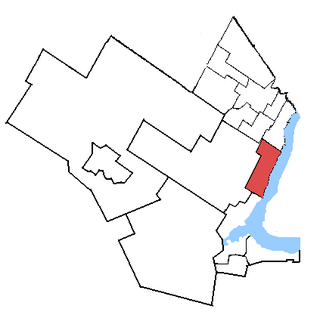
Oakville is a federal electoral district in Ontario, Canada, that has been represented in the House of Commons of Canada since 1997.

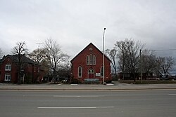
Bronte is the community that makes up much of the west end of Oakville, in Ontario, Canada. Twelve Mile Creek flows through the middle of town and empties into Lake Ontario. Main roads include Bronte Road (north-south), Lakeshore Road West and Rebecca Street (east-west). Streets in the business section include Lakeshore, Jones, Marine, and Ontario Street. Bronte is also accessed via a superhighway located to the north of the former village. Other main roads include Third Line, Speers Road and Burloak Drive to the west

Bronte GO Station is a train station in the GO Transit network located in Oakville, Ontario, Canada. It is a stop on the Lakeshore West line and there is an adjacent bus loop for connecting local Oakville Transit bus routes.

Sixteen Mile Creek is a river in Halton Region in the Greater Toronto Area of Ontario, Canada. It is in the Great Lakes Basin, and flows from the Niagara Escarpment through the towns of Milton and Oakville to Lake Ontario.

Ashburn is a hamlet in the town of Whitby, Durham Region, Ontario, Canada, located approximately 15 kilometres north of the town core, and centred on the intersection of Ashburn Road and Myrtle Road. It is a rural settlement area on the Oak Ridges Moraine, situated on the headwaters of the Lynde Creek watershed and part of Ontario's protected Golden Horseshoe Greenbelt.

William McCraney was a businessman and political figure in Ontario, Canada. He represented Halton in the House of Commons of Canada as a Liberal member from 1875 to 1878 and from 1882 to 1887.
Halton was a provincial electoral district in Central Ontario, Canada. It elected one member to the Legislative Assembly of Ontario.

Lemonville is a hamlet in York Region, Ontario, Canada, in the town of Whitchurch–Stouffville. The hamlet is centred at the intersection of McCowan Road and Bloomington Road, in the geographical centre of Whitchurch-Stouffville.
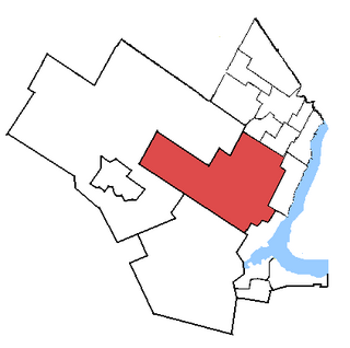
Oakville is a provincial electoral district in Ontario, Canada, that has been represented in the Legislative Assembly of Ontario since 1999.
King's Highway 25, commonly referred to as Highway 25, was a highway in the Canadian province of Ontario. The north–south route connected several towns on its route northward from Burlington. The first section of Highway 25, designated in 1925, travelled north from Highway 5 to Milton. In 1928, the route was extended south into Burlington, following portions of Lower Middle Road to Highway 2. The highway was extended north to Highway 7 in 1937. That same year, a portion of Highway 25 was made concurrent with The Middle Road, which would be renamed as the Queen Elizabeth Way (QEW) two years later. The route remained relatively unchanged for two decades, save for the southern end being truncated at the QEW in 1946. In 1963 it was extended north to Ospringe to meet Highway 24. Another extension was added in 1974 to bring the route to Highway 89 near Shelburne. The entire route was decommissioned in 1997 and 1998 as part of a province-wide downloading of highways deemed to be of regional importance.
Esquesing Township was a municipality within the historic Halton County in Ontario, Canada. It is today a geographic township in the town of Halton Hills in the Regional Municipality of Halton.

Canton is a hamlet in southeastern Ontario, a few kilometers north of Port Hope. It has a small wooden chapel built in 1832, one of the oldest in the region. Canton was once the home of Vincent Massey, the lawyer, diplomat and Governor General of Canada.

Lakeshore Road is a historic roadway in the Canadian province of Ontario, running through the city of Burlington and the town of Oakville in Halton Region, as well as the city of Mississauga in Peel Region. As its name implies, the road closely follows the shoreline of Lake Ontario, although the lake itself is not visible from the road in most areas. Lakeshore Road was once a key section of the historic Highway 2, which traversed the province, but has since been downloaded to local municipalities. Despite this historical role as a major route, however, most of the road is a lower-capacity picturesque residential and historic commercial street with only two through lanes until it becomes a four-lane, higher-volume artery after it enters Mississauga and jogs to the north.