Limehouse, Ontario

Last updated

Limehouse
Unincorporated community
Limehouse - Laslovarga (27).jpg
Memorial Hall
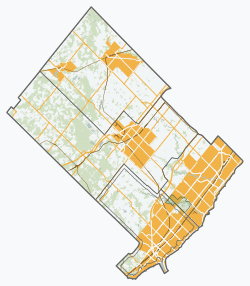
Halton locator map 2021.svg
Red pog.svg
Limehouse
Canada Southern Ontario location map 2.png
Red pog.svg
Limehouse
Coordinates: 43°38′11″N79°58′46″W / 43.63639°N 79.97944°W / 43.63639; -79.97944 Coordinates: 43°38′11″N79°58′46″W / 43.63639°N 79.97944°W / 43.63639; -79.97944
CountryCanada
Province Ontario
Regional municipality Halton
Town Halton Hills
Time zone UTC−05:00 (EST)
  Summer (DST) UTC−04:00 (EDT)
Forward sortation area
Area code(s) 905 and 289
NTS Map030M12
GNBC CodeFBXQM

Limehouse is a community in the Town of Halton Hills in southern Ontario, Canada. It has a population of about 800 people and its closest neighbours are Georgetown and Acton. Limehouse has many hills, trails and even a small school.
Contents

Limehouse Public School

Limehouse school has an enrolment of fewer than 200 children in junior kindergarten through grade 5. [1] Limehouse competes with schools in the surrounding area in sports, such as track-and-field, cross-country, and volleyball. The school itself is quite small, with one hallway and a gymnasium.

The Bruce Trail

This is the main attraction for the small community of Limehouse. The Bruce Trail is a hiking trail in Ontario that runs from Queenston on the Niagara River, to Tobermory on the Bruce Peninsula in Lake Huron. The over 800 km (500 mi) long trail follows the course of the Niagara Escarpment, often along its edge. Many parts of the trail go unused, although the Limehouse entrance sees a lot of tourism.

History

The Bruce trail contains the very reason Limehouse is a place on the map today: the kilns. Best accessed through the Limehouse Conservation Area the lime kilns can be found throughout the Limehouse section of the Bruce Trail. The kilns are slowly deteriorating because of age. However, the largest of them, a draw kiln, is currently being restored. A train station used to exist near the entrance of the Bruce Trail, and the earthen siding can be seen on the south side of the tracks, just east of the one lane car bridge that spans the rail road tracks. The rail bed for the former Toronto Suburban Railway can be seen about a kilometre west of the bridge on 22nd Side Road where it used to cross the road. The rail bed runs behind the gun club and east where it crossed 5th Line and the wood pilings can be seen in what used to be the head pond in what is now the Credit Valley Conservation Limehouse Park. The head pond is just some north of the Hole in the Wall feature of the Bruce Trail. On satellite maps of the area, you can if you look closely, trace the track-bed of the radial railway all the way back to Georgetown.

There are also caves and seemingly never-ending crevices along the Bruce Trail. There are bridges and ladders leading throughout some parts of the trail, and there are designated biking sections of it as well. The area is not policed, so these areas should be explored at one's own risk.

Economy

Agriculture

There are many farms and fields located in Limehouse. On 5th and 4th Line, the outskirts of Limehouse, you can drive and seemingly think you were hundreds of miles away from any cities. Particularly, on 4th Line there is the Mountainview Farm which is run by a single family. They race a few of their 35 horses at Woodbine Racetrack and have wild boar at their farm. This is only one example of the many other similar families. There are also riding lessons provided on 17th Sideroad, provided by a family farm.

Activities

There is a community centre located in the heart of Limehouse, just around the corner from Limehouse School and the Junkyard, the latter being in the process of clearing and rehabilitating. Events are held at the time of holidays throughout the year, as well as for various community functions.

Quarries

There are quarries throughout Limehouse in which people have mined limestone for more than a century. Currently, Duff Quarry is up and running and sponsoring many events for Limehouse Public School. Once inside the quarries, you can see machinery spread out over great distances, and stone piles that are many metres high.

Related Research Articles

<span class="mw-page-title-main">Bruce Trail</span> Hiking trail in Ontario, Canada

The Bruce Trail is a hiking trail in southern Ontario, Canada, from the Niagara River to the tip of Tobermory, Ontario. The main trail is more than 890 km (550 mi) long and there are over 400 km (250 mi) of associated side trails. The trail mostly follows the edge of the Niagara Escarpment, one of the nineteen UNESCO World Biosphere Reserves in Canada. The land the trail traverses is owned by the Government of Ontario, local municipalities, local conservation authorities, private landowners, and the Bruce Trail Conservancy (BTC). The Bruce Trail is the oldest and longest marked hiking trail in Canada. Its name is linked to the Bruce Peninsula and Bruce County, through which the trail runs. The trail is named after the county, which was named after James Bruce, 8th Earl of Elgin who was Governor General of the Province of Canada from 1847 to 1854.

<span class="mw-page-title-main">Niagara Escarpment</span> Escarpment in Canada and the United States

The Niagara Escarpment is a long escarpment, or cuesta, in Canada and the United States that runs predominantly east–west from New York through Ontario, Michigan, Wisconsin, and into Illinois. The escarpment is most famous as the cliff over which the Niagara River plunges at Niagara Falls, for which it is named.

<span class="mw-page-title-main">St. Catharines</span> City in Ontario, Canada

St. Catharines is the largest city in Canada's Niagara Region and the sixth largest urban area in the province of Ontario. As of 2016, it has an area of 96.13 square kilometres (37.12 sq mi), 136,803 residents, and a metropolitan population of 406,074. It lies in Southern Ontario, 51 kilometres (32 mi) south of Toronto across Lake Ontario, and is 19 kilometres (12 mi) inland from the international boundary with the United States along the Niagara River. It is the northern entrance of the Welland Canal. Residents of St. Catharines are known as St. Catharinites. St. Catharines carries the official nickname "The Garden City" due to its 1,000 acres (4 km2) of parks, gardens, and trails.

<span class="mw-page-title-main">Welland</span> City in Ontario, Canada

Welland is a city in the Regional Municipality of Niagara in Southern Ontario, Canada. As of 2021, it had a population of 55,750.

<span class="mw-page-title-main">Georgetown, Ontario</span> Community in Ontario, Canada

Georgetown is a large unincorporated community in the town of Halton Hills, Ontario, Canada, in the Regional Municipality of Halton. The town includes several small villages or settlements such as Norval, Limehouse, Stewarttown and Glen Williams near Georgetown and another large population centre, Acton. In 2016, the population of Georgetown was 42,123. It sits on the banks of the Credit River, approximately 40 km west of Toronto, and is part of the Greater Toronto Area. Georgetown was named after entrepreneur George Kennedy who settled in the area in 1821 and built several mills and other businesses.

<span class="mw-page-title-main">Halton Hills</span> Town in Ontario, Canada

Halton Hills is a town in the Regional Municipality of Halton, located in the northwestern end of the Greater Toronto Area, Ontario, Canada with a population of 61,161 (2016).

<span class="mw-page-title-main">Queenston</span> Town in Ontario, Canada

Queenston is a compact rural community and unincorporated place 5 kilometres (3.1 mi) north of Niagara Falls in the Town of Niagara-on-the-Lake, Ontario, Canada. It is bordered by Highway 405 to the south and the Niagara River to the east; its location at the eponymous Queenston Heights on the Niagara Escarpment led to the establishment of the Queenston Quarry in the area. Across the river and the Canada–US border is the village of Lewiston, New York. The Lewiston-Queenston Bridge links the two communities. This village is at the point where the Niagara River began eroding the Niagara Escarpment. During the ensuing 12,000 years the Falls cut an 11 kilometres (6.8 mi) long gorge in the Escarpment southward to its present-day position.

The Toronto Suburban Railway was a Canadian electric railway operator with local routes in west Toronto, and a radial (interurban) route to Guelph.

Wadsley Bridge is a suburb of Sheffield, South Yorkshire, England, 3 miles (4.8 km) northwest of the city centre. The area is a mixture of residential housing and small industrial and commercial premises. The suburb falls within the Hillsborough ward of the City.

<span class="mw-page-title-main">Saugeen Shores</span> Town in Ontario, Canada

Saugeen Shores is a town in Bruce County, Ontario, Canada, formed in 1998. In addition to the two main population centres of Southampton and Port Elgin, the town includes a portion of the village of Burgoyne and the North Bruce area, straddling the municipal eastern and southern boundary respectively. In 2016, the permanent population of Saugeen Shores was 13,715, in a land area of 171.05 square kilometres (66.04 sq mi).

<span class="mw-page-title-main">Port Elgin, Ontario</span> Community in Ontario, Canada

Port Elgin is a community in Bruce County, Ontario, Canada. Its location is in the traditional territory of the Saugeen Ojibway Nation. Originally named Normanton the town was renamed Port Elgin when it was incorporated in 1874, after James Bruce, 8th Earl of Elgin, a former Governor General of the Province of Canada.

<span class="mw-page-title-main">West Toronto Railpath</span> Multi-use trail in Toronto, Canada

The West Toronto Railpath is a multi-use trail in Toronto, Ontario, Canada, running from The Junction neighbourhood toward downtown Toronto. The Railpath was developed by the City of Toronto for bicycle and pedestrian use. Like Toronto's Beltline and Don Mills trails, it is an urban rail-to-trail project. Phase 1 of the path opened in 2009. Phase 2, an extension south from Dundas Street West to Liberty Village, was approved and proceeding with detailed design as of September 2020 with funding of $2.9 million jointly from the City and the Government of Canada. Construction of Phase 2 is expected to begin in 2023.

<span class="mw-page-title-main">Columbus and Franklin County Metro Parks</span> Park district in Central Ohio

The Columbus and Franklin County Metro Parks are a group of 19 metropolitan parks in and around Columbus, Ohio. They are officially organized into the Columbus and Franklin County Metropolitan Park District. The Metro Parks system was organized in 1945 under Ohio Revised Code Section 1545 as a separate political division of the state of Ohio. The Metro Parks are overseen by a Board of Park Commissioners consisting of three citizens appointed to three-year terms without compensation by the Judge of the Probate Court of Franklin County, Ohio. The Board in turn appoints an Executive Director responsible for operations and management of the parks.

<span class="mw-page-title-main">Mono Cliffs Provincial Park</span> Provincial park in Ontario, Canada

Mono Cliffs Provincial Park lies within the rural town of Mono, in southern Ontario, Canada, along the Bruce Trail. It is part of the Niagara Escarpment Parks System, and the escarpment Biosphere Reserve.

<span class="mw-page-title-main">Geography of Hamilton, Ontario</span>

Hamilton is located on the western end of the Niagara Peninsula and wraps around the westernmost part of the Lake Ontario. Most of the city including the downtown section lies along the south shore. Situated in the geographic centre of the Golden Horseshoe, it lies roughly midway between Toronto and Buffalo. The two major physical features are Hamilton Harbour marking the northern limit of the city and the Niagara Escarpment running through the middle of the city across its entire breadth, bisecting the city into 'upper' and 'lower' parts.

<span class="mw-page-title-main">Kenilworth Avenue (Hamilton, Ontario)</span>

Kenilworth Avenue is a Lower City arterial road in Hamilton, Ontario, Canada. It starts off at the Kenilworth Traffic Circle and Kenilworth Access, a mountain-access road at the base of the Niagara Escarpment (mountain) and is a two-way street throughout stretching northward through the city's North End industrial neighbourhood where it then flows underneath the Burlington Street bridge and right into Dofasco's Industrial Park.

<span class="mw-page-title-main">Lea Valley Walk</span> Long-distance footpath in South East England

The Lea Valley Walk is a 50-mile (80 km) long-distance path located between Leagrave, the source of the River Lea near Luton, and the Thames, at Limehouse Basin, Limehouse, east London. From its source much of the walk is rural. At Hertford the path follows the towpath of the River Lee Navigation, and it becomes increasingly urbanised as it approaches London. The walk was opened in 1993 and is waymarked throughout using a swan logo.

<span class="mw-page-title-main">Limehouse Conservation Area</span>

Limehouse Conservation Area is located on the Niagara Escarpment near Limehouse, Ontario and is owned and operated by Credit Valley Conservation. It is within the watershed of the Credit River, being bisected by its tributary, the Black Creek. Redside dace, a provincially threatened species of fish, is found there. The area is known for a system of deep rock fissures and crevices, some of which are accessible from a trail via ladders at the location known as the "Hole in the Wall". Remains of the 19th century lime kilns can be found in the area, making it a site of the regional cultural heritage.

<span class="mw-page-title-main">Bay Circuit Trail</span> Long-distance hiking trail in the United States

The Bay Circuit Trail and Greenway or Bay Circuit is a Massachusetts rail trail and greenway connecting the outlying suburbs of Boston from Plum Island in Newburyport to Kingston Bay in Duxbury, a distance of 200 miles (320 km).

<span class="mw-page-title-main">Dundas Valley Conservation Area</span>

Dundas Valley Conservation Area is located on the Niagara Escarpment in Dundas, Ontario, a constituent community of Hamilton, Ontario, and is owned and operated by the Hamilton Conservation Authority. Its 40-kilometre trail system provides a connection to the Bruce Trail. The area contains a trailhead of the Hamilton-Brantford-Cambridge Trails, Canada's first fully developed interurban multi-use trail system, which is a part of the Trans Canada Trail.

References

  1. "School Details".