Sioux Valley Dakota Nation

Last updated

Sioux Valley Dakota Nation
Wipazoka Wakpa
People Dakota
Headquarters Griswold, Manitoba R0M 0S0
Government
ChiefVincent Tacan [1]
Tribal Council
Dakota Ojibway Tribal Council
Website
svdngovernance.com
Canada Manitoba location map 2.svg
Red pog.svg
Sioux
Valley
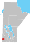
Location of the Sioux Valley Dakota Nation Reserve in Manitoba

Sioux Valley Dakota Nation (SVDN) or Wipazoka Wakpa ('Saskatoon River', named for the abundance of Saskatoon bushes along the river) [2] is a Dakota (Sioux) First Nation that resides west of Brandon, Manitoba.

Contents

The Sioux Valley Dakota Nation has a total population of around 2,400. [3] Around 1,080 of the population resides on the Sioux Valley Dakota Nation Reserve, [4] which is located by the southeast corner of the Rural Municipality of Wallace - Woodworth.

Sioux Valley Dakota Nation is comprised of the Eastern Dakota bands of the Seven Council Fires. The Sisituŋwaŋ, Waȟpetuŋwaŋ, Bdewakaŋtuŋwaŋ, and Waȟpe Kute.

Reserves

The First Nation have two reserves, their main reserve and one in which they share.

Notes

  1. https://svdngovernance.com/governance-news/svdn-elections-2023-chief-council-23-25-official-results/.{{cite web}}: Missing or empty |title= (help)
  2. "Manitoba First Nations Education Resource Centre Inc. - Traditional First Nations Community Names" (PDF). Archived from the original (PDF) on 2021-12-04. Retrieved 2020-11-24.
  3. "Sioux Valley Dakota Nation". Sioux Valley Dakota Nation. Retrieved 2010-07-03.
  4. "Sioux Valley Dakota National, IRI". Statistics Canada. 2006. Retrieved 2010-07-03.

49°51′00″N100°29′58″W / 49.85000°N 100.49944°W / 49.85000; -100.49944


Related Research Articles

<span class="mw-page-title-main">Minnehaha County, South Dakota</span> County in South Dakota, United States

Minnehaha County is a county on the eastern border of the state of South Dakota. As of the 2020 census, the population was 197,214, making it the state's most populous county. It contains over 20% of the state's population. Its county seat is Sioux Falls, South Dakota's most populous city. The county was created in 1862 and organized in 1868. Its name was derived from the Sioux word Mnihaha, meaning "rapid water," or "waterfall".

<span class="mw-page-title-main">Red River Valley</span> Region in central North America that is drained by the Red River of the North

The Red River Valley is a region in central North America that is drained by the Red River of the North; it is part of both Canada and the United States. Forming the border between Minnesota and North Dakota when these territories were admitted as states in the United States, this fertile valley has been important to the economies of these states and to Manitoba, Canada.

<span class="mw-page-title-main">Westman Region</span> Region in Manitoba, Canada

The Westman Region is an informal geographic region of the Canadian province of Manitoba located in the southwestern corner of the province.

A tribal council is an association of First Nations bands in Canada, generally along regional, ethnic or linguistic lines.

<span class="mw-page-title-main">Shakopee Mdewakanton Sioux Community</span> Indian tribe community in Scott County, Minnesota, United States

The Shakopee Mdewakanton Sioux Community (SMSC) (Dakota: Bdemayaṭo Oyate) is a federally recognized, sovereign Indian tribe of Mdewakanton Dakota people, located southwest of Minneapolis and Saint Paul, within parts of the cities of Prior Lake and Shakopee in Scott County, Minnesota. Mdewakanton, pronounced Mid-ah-wah-kah-ton, means "dwellers at the spirit waters."

First Nations in Manitoba constitute of over 160,000 registered persons as of 2021, about 57% of whom live on reserve. Manitoba is second to Ontario in total on-reserve population and in total First Nation population.

Roseau River Anishinabe First Nation is an Ojibway First Nation in southern Manitoba, Canada, situated around the Roseau River.

The Mdewakanton or Mdewakantonwan are one of the sub-tribes of the Isanti (Santee) Dakota (Sioux). Their historic home is Mille Lacs Lake in central Minnesota. Together with the Wahpekute, they form the so-called Upper Council of the Dakota or Santee Sioux. Today their descendants are members of federally recognized tribes in Minnesota, South Dakota and Nebraska of the United States, and First Nations in Manitoba, Canada.

<span class="mw-page-title-main">Dakota people</span> Native American people in the mid northern U.S. and mid southern Canada

The Dakota are a Native American tribe and First Nations band government in North America. They compose two of the three main subcultures of the Sioux people, and are typically divided into the Eastern Dakota and the Western Dakota.

Northwest Angle 33 First Nation is an Ojibwe or Ontario Anishinaabe First Nation band government who reside in Kenora District, Ontario near Sioux Narrows of Lake of the Woods.

Wabaseemoong Independent Nations or more fully as the Wabaseemoong Independent Nations of One Man Lake, Swan Lake and Whitedog, is an Ojibway First Nation band government who reside 120 km northwest of Kenora, Ontario and 13 kilometres (8.1 mi) east of the Ontario-Manitoba border of northwestern Ontario, Canada. As of December 2018, the First Nation had a population of 2,000 registered people, of which their on-Reserve population was 1200 registered members and approximately 100 non-Band members.

<span class="mw-page-title-main">Division No. 6, Manitoba</span> Census division in Manitoba, Canada

Division No. 6 (Virden) is a census division located within the Westman Region of south west Manitoba, located in the unceded territory of the Dakota people in Treaty 2. Unlike in some other provinces, census divisions do not reflect the organization of local government in Manitoba. These areas exist solely for the purposes of statistical analysis and presentation; they have no government of their own.

The Rural Municipality of Woodworth is a former rural municipality (RM) in the Canadian province of Manitoba. It was originally incorporated as a rural municipality on December 22, 1883. It ceased on January 1, 2015 as a result of its provincially mandated amalgamation with the RM of Wallace and the Village of Elkhorn to form the Rural Municipality of Wallace – Woodworth.

<span class="mw-page-title-main">Thunder Butte</span> Geographic feature in South Dakota, United States

Thunder Butte is a prominent butte landmark located in the northwest corner of Ziebach County, South Dakota, in the United States. Thunder Butte is a large, isolated hill that can be seen for many miles in every direction, and has served throughout history as an important orientation point for area residents or a navigational aide for travelers crossing the surrounding plains. The butte gives its name to a small community at its base, and to a small creek that runs into the Moreau River.

The Dakota Ojibway Tribal Council (DOTC) is a First Nations tribal council in southern Manitoba, Canada, consisting of 6 Dakota and Ojibway band governments.

The Naicatchewenin First Nation, also known as the Anishinaabeg of Nagaajiwanaang and formerly known as Northwest Bay First Nation, inhabited a region in Ontario that was cited in the Northwest Angle Treaty of 1873, also known as Treaty 3. Nagaajiwanaang is located approximately 60 kilometres (37 mi) northwest of Fort Frances, with the community of Devlin 50 kilometres (31 mi) to the south on Highway 11. The city of Thunder Bay lies 420 kilometres (260 mi) to the east and Winnipeg is 450 kilometres (280 mi) to the northwest.

Birdtail Sioux First Nation or Chan Kagha Otina Dakhóta Oyáte are a Dakota First Nation located approximately 50 km north of Virden, Manitoba. The First Nation has a population of approximately 643 people on approximately 7,128 acres (28.85 km2) of land.

The Canupawakpa Dakota First Nation or Chanupa Wakpa is a First Nations in western Manitoba, located on Oak Lake Reserve - 59A.

Whitecap Dakota First Nation is a Dakota First Nations band government whose reserve is located 26 km (16 mi) south of Saskatoon, Saskatchewan, Canada. Governing the Whitecap Indian Reserve No. 94, historically referred to as the Moose Woods Sioux Reserve, it is bordered by the Rural Municipality of Dundurn No. 314 and located along Highway 219 between the South Saskatchewan River and CFAD Dundurn.