Cartwright is an unincorporated urban community in the Cartwright – Roblin Municipality within the Canadian province of Manitoba that held village status prior to January 1, 2015. It was originally incorporated as a village on December 31, 1947.

West St. Paul is a rural municipality (RM) in Manitoba, Canada. It lies adjacent to the north side of Winnipeg, and directly west of the Red River. It is part of the Winnipeg Metro Region, and had a population of 5,368 at the 2016 census.

East St. Paul is a rural municipality (RM) in Manitoba, Canada. It is located north-east of and adjacent to the city of Winnipeg, and is part of the Winnipeg Metropolitan Area. The municipality was formed on 3 November 1915 when the municipality of St. Paul (1888-1914) was subdivided into West St. Paul and East St. Paul, with the Red River acting as the dividing line.
Mitchell is a local urban district and population centre located in the Rural Municipality of Hanover, Manitoba, Canada. It is located three kilometers west of Steinbach, Manitoba along Provincial Highway 52. The community has a population of 3,136 as of 2016, making Mitchell the 22nd largest population centre in Manitoba.

Springfield is a rural municipality (RM) in Manitoba, Canada. It stretches from urban industrial development on the eastern boundary of the city of Winnipeg, through urban, rural residential, agricultural and natural landscapes, to the Agassiz Provincial Forest on the municipality's eastern boundary. Birds Hill Provincial Park nestles into the north-western corner of Springfield.
Reston is an unincorporated community recognized as a local urban district in southwestern Manitoba, located near the border of Saskatchewan on the west and North Dakota on the south. It is the largest community in the Rural Municipality of Pipestone, which also includes Sinclair, Cromer and Pipestone.

Warren is an unincorporated community recognized as a local urban district 26.3 kilometres north-west of Winnipeg, Manitoba. It is located in the Rural Municipality of Woodlands.

The Rural Municipality of Walpole No. 92 is a rural municipality (RM) in the Canadian province of Saskatchewan within Census Division No. 1 and SARM Division No. 1.

Cromer, Manitoba is a village located in the Rural Municipality of Pipestone, in south-western Manitoba, Canada in a region called Westman.
The Rural Municipality of Oakdale No. 320 is a rural municipality (RM) in the Canadian province of Saskatchewan within Census Division No. 13 and SARM Division No. 6. Located in the west-central portion of the province, it is near the Alberta boundary.

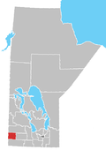
Pipestone is a rural municipality (RM) in the southwestern part of the province of Manitoba in Western Canada
The Rural Municipality of Lipton No. 217 is a rural municipality (RM) in the Canadian province of Saskatchewan within Census Division No. 6 and SARM Division No. 1.
Tilston is a small community in the Municipality of Two Borders, Manitoba, Canada. The community is located at the junction of Road 256 and Road 345, approximately 144 km south-west of Brandon, Manitoba only 58 kilometers south-west of the Town of Hartney.
Woodnorth is an unincorporated community in southwestern Manitoba, Canada. It is located approximately 17 kilometers southwest of Virden, Manitoba in the Rural Municipality of Pipestone.
Scarth is an unincorporated community in southwestern Manitoba, Canada. It is located approximately 13 kilometers south of Virden, Manitoba in the Rural Municipality of Pipestone.
Ebor is an unincorporated community in southwestern Manitoba, Canada. It is approximately 31 kilometers southwest of Virden, Manitoba in the Rural Municipality of Pipestone.
Decker is an unincorporated community in southwestern Manitoba, Canada. It is located approximately 17 kilometers northwest of Hamiota, Manitoba in the Hamiota Municipality.
Arrow River is an unincorporated community in southwestern Manitoba, Canada. It is located approximately 10 kilometers east of Miniota, Manitoba in the Prairie View Municipality.
Kola is an unincorporated community in southwestern Manitoba, Canada. It is located approximately 31 kilometres (19 mi) west of Virden and approximately 3 kilometres (1.9 mi) east of the Saskatchewan boundary in the Rural Municipality of Wallace.

Cartwright–Roblin Municipality is a rural municipality in the Canadian province of Manitoba.