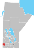
Kenton, Manitoba

Last updated

Kenton is an unincorporated community recognized as a local urban district [1] in Manitoba, Canada. It is located in the Rural Municipality of Woodworth, about an hour's drive west of Brandon. The first permanent settlement of the area began in 1881, following the westward expansion of the borders of the province of Manitoba. The settlement was named for its first postmaster, A.W. Kent. [2] Kenton became an unincorporated village district in 1947. [3] In 1986, the community had a population of 158. [4] Water supply for the community is from the nearby half-mile long Kenton Reservoir on Bars Creek, a tributary of the Oak River. The 600 acre foot reservoir was constructed in 1969 by the Prairie Farm Rehabilitation Administration [5] and also provides an opportunity for sport fishing. Kenton is the location of the municipal council chamber for the RM of Woodworth.

Services

Kenton features a full service Campground and Swimming area, Walking Trail, Hockey Rink, Curling Rink, Grocery Store, Restaurant, Vehicle Dealership, Legion, Community Hall, Gas Station, Liquor Store, Lumber Yard, and Fiber Optic internet (300 Mbit/s). [6] [7] [8] [9] [10] [11] . [12] [13] A railway branch line connected Kenton in 1902. The local lighting plant was replaced with a connection to the provincial electric power grid in 1931. The Rural Municipality of Woodworth ran its own municipal telephone system from 1907 with the main exchange at Kenton, until the system was sold to the provincial telephone company in 1946.

Related Research Articles

<span class="mw-page-title-main">Rural Municipality of Gimli</span> Rural municipality in Manitoba, Canada

The Rural Municipality of Gimli is a rural municipality located in the Interlake Region of south-central Manitoba, Canada, on the western shore of Lake Winnipeg. It is about 75 kilometres (47 mi) north of the provincial capital Winnipeg. The rural municipality's population in the 2016 Canadian Census was 6,181, making it the 12th largest rural municipality by population. The RM of Gimli has an area of 318.75 km2 (123.07 sq mi), making it the sixth smallest rural municipality by area.

The Rural Municipality of Lakeview was a rural municipality (RM) in the Canadian province of Manitoba.

<span class="mw-page-title-main">Rural Municipality of West St. Paul</span> Rural municipality in Manitoba

West St. Paul is a rural municipality (RM) in Manitoba, Canada. It lies adjacent to the north side of Winnipeg, and directly west of the Red River. It is part of the Winnipeg Metro Region, and had a population of 5,368 at the 2016 census.

The Rural Municipality of Bifrost is a former rural municipality (RM) in the Canadian province of Manitoba.

The Rural Municipality of Cameron is a former rural municipality (RM) in the Canadian province of Manitoba. It was originally incorporated as a rural municipality on November 16, 1896. It ceased on January 1, 2015, as a result of its provincially mandated amalgamation with the RM of Whitewater and the Town of Hartney to form the Municipality of Grassland.

<span class="mw-page-title-main">Rural Municipality of Headingley</span> Rural municipality in Manitoba, Canada

Headingley is a rural municipality in Manitoba, Canada. It is located directly west of Winnipeg and had a population of 3,579 people as of the 2016 census.

<span class="mw-page-title-main">St. James-Assiniboia, Winnipeg</span> Suburb in Winnipeg, Manitoba, Canada

St. James-Assiniboia is a major community area in Winnipeg, Manitoba, Canada. As it encapsulates most of the city ward of St. James, which includes the major St. James Street, the area itself is often simply referred to "St. James."

<span class="mw-page-title-main">Elkhorn, Manitoba</span> Place in Manitoba, Canada

Elkhorn is an unincorporated community recognized as a local urban district in the Rural Municipality of Wallace – Woodworth within the Canadian province of Manitoba that held village status prior to January 1, 2015. It was originally incorporated as a village on January 2, 1906. Elkhorn is located approximately 105 kilometres (65 mi) west of Brandon.

<span class="mw-page-title-main">Rural Municipality of Taché</span> Rural municipality in Manitoba, Canada

Taché is a rural municipality in Manitoba, Canada, incorporated in 1880.

Île-des-Chênes is an unincorporated community in Manitoba, Canada, within the Rural Municipality of Ritchot. The community is located 13 kilometres south-east of the provincial capital Winnipeg, just east of Highway 59. Île-des-Chênes is a French name, translating to Island of the Oaks, coming from a nearby stand of oaks on higher ground, where early settlers sought refuge from the annual spring floodwaters.

<span class="mw-page-title-main">Rural Municipality of Sifton</span> Rural municipality in Manitoba, Canada

The Rural Municipality of Sifton is a rural municipality (RM) in the south-west portion of the Canadian province of Manitoba.

The Rural Municipality of Wallace is a former rural municipality (RM) in the Canadian province of Manitoba. It was originally incorporated as a rural municipality on December 22, 1883. It ceased on January 1, 2015 as a result of its provincially mandated amalgamation with the RM of Woodworth and the Village of Elkhorn to form the Rural Municipality of Wallace – Woodworth.

The Rural Municipality of Woodworth is a former rural municipality (RM) in the Canadian province of Manitoba. It was originally incorporated as a rural municipality on December 22, 1883. It ceased on January 1, 2015 as a result of its provincially mandated amalgamation with the RM of Wallace and the Village of Elkhorn to form the Rural Municipality of Wallace – Woodworth.

<span class="mw-page-title-main">Rural Municipality of North Cypress</span> Place in Manitoba, Canada

The Rural Municipality of North Cypress is a former rural municipality (RM) in the Canadian province of Manitoba. It was originally incorporated as a rural municipality on January 1, 1883. It ceased on January 1, 2015 as a result of its provincially mandated amalgamation with the RM of Langford to form the Municipality of North Cypress – Langford.

<span class="mw-page-title-main">Rural Municipality of Ste. Anne</span> Rural municipality in Manitoba, Canada

Ste. Anne is a rural municipality (RM) in the Eastman Region of Manitoba, Canada, lying southeast of Winnipeg. The separately-administered town of Ste. Anne lies within the geographic borders of the municipality, in its northwestern part.

The Rural Municipality of South Norfolk is a former rural municipality (RM) in the Canadian province of Manitoba. It was originally incorporated as a rural municipality on December 22, 1883. It ceased on January 1, 2015, as a result of its provincially mandated amalgamation with the Town of Treherne to form the Municipality of Norfolk Treherne.

Prawda is an unincorporated community in the Rural Municipality of Reynolds, situated a few miles east of Hadashville on the Trans Canada Highway in eastern Manitoba. The population of this community is 200. The community's amenities include two service stations/convenience store & restaurants, a Tesla Supercharger, and a campground (Pinetree).

<span class="mw-page-title-main">Rural Municipality of Ellice-Archie</span> Rural municipality in Manitoba, Canada

The Rural Municipality of Ellice-Archie is a rural municipality (RM) in the Canadian province of Manitoba.

<span class="mw-page-title-main">Grandview Municipality</span> Rural municipality in Manitoba, Canada

Grandview Municipality is a rural municipality (RM) in the Parkland Region of Manitoba, Canada. It is located in a valley between Duck Mountain Provincial Forest & Park and Riding Mountain National Park, which both lie partially within the RM's territory.

<span class="mw-page-title-main">Rural Municipality of Wallace-Woodworth</span> Rural municipality in Manitoba, Canada

The Rural Municipality of Wallace-Woodworth is a rural municipality (RM) in the Canadian province of Manitoba that incorporated on January 1, 2015, via the amalgamation of the RMs of Wallace and Woodworth and the village of Elkhorn. It was formed as a requirement of The Municipal Amalgamations Act, which required that municipalities with a population less than 1,000 amalgamate with one or more neighbouring municipalities by 2015. The Government of Manitoba initiated these amalgamations in order for municipalities to meet the 1997 minimum population requirement of 1,000 to incorporate a municipality.

References

  1. "Local Urban Districts Regulation". Government of Manitoba. April 23, 2016. Retrieved April 24, 2016.
  2. http://www.insurancewest.ca/pdffiles/IW_nov06_11-20.pdf retrieved 2011 Dec 1
  3. Dorthy Vipond, Proudly we speak: a history of the Rural Municipality of Woodworth, Woodworth Centennial Committee, 1967, http://www.ourroots.ca/e/page.aspx?id=482986
  4. http://mbair.brandonu.ca/figure/display/16.4 Manitoba from the air, retrieved 2011 12 01
  5. http://uarcd.com/PDFs/OctWPATLgeDam.pdf retrieved 2011 12 01
  6. "Historic Sites of Manitoba: Lawlor House / Woodworth Millennium Museum (Kenton, RM of Wallace-Woodworth)". www.mhs.mb.ca. Retrieved December 9, 2021.
  7. "Redfern Farm Services | Serving Western Manitoba Farmers since 1973" . Retrieved December 9, 2021.
  8. tcameron. "Kenton Community Rink Bookings". www.wallace-woodworth.com. Retrieved December 9, 2021.
  9. "Woodworth Chrysler Dodge Jeep". www.woodworthdodge.ca.
  10. "Lonesome Oak Campgrounds". lonesomeoakcampgrounds.webs.com. Retrieved December 9, 2021.
  11. "Brierwood Creek Cafe & Grill". www.facebook.com.
  12. "ValleyView Co-op". www.valleyviewco-op.crs.
  13. "RFNOW Inc. | High Speed Internet - Fibre & Wireless Plans". www.rfnow.com.

49°59′15″N100°36′51″W / 49.98750°N 100.61417°W / 49.98750; -100.61417