Howden, Manitoba

Last updated
Howden
Canada Manitoba location map 2.svg
Red pog.svg
Howden
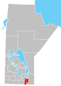
Location of Aubigny in Manitoba
Coordinates: 49°43′6″N97°7′34.4″W / 49.71833°N 97.126222°W / 49.71833; -97.126222 Coordinates: 49°43′6″N97°7′34.4″W / 49.71833°N 97.126222°W / 49.71833; -97.126222
CountryCanada
Province Manitoba
Rural Municipality R.M. of Ritchot
Government
  MayorChris Ewen
  Councillor (Ward 4)Janine Boulanger
   MP (Provencher) Ted Falk (CPC)
   MLA (Springfield-Ritchot) Ron Schuler (PC)
Time zone UTC−6 (CST)
  Summer (DST) UTC−5 (CDT)

Howden is a hamlet in the province of Manitoba, Canada. [1] It is located 17 kilometres (11 miles) south of downtown Winnipeg within the Rural Municipality of Ritchot.

Contents

Etymology

Howden is named for James H. Howden, who was the Provincial Treasurer in the government of Sir Rodmond Roblin. [2]

History

In 1898, St. François de Sales School was opened in Howden, which burnt down in 1939 and was replaced by Queen Elizabeth School, named for Queen Elizabeth The Queen Mother. The new school was rebuilt in 1950, after the flood of that year, and again in 1955 after it was destroyed by fire, finally closing in 1967. [3] A post office was opened in 1927, which was closed in 1948. [4]

Churches

A Roman Catholic church was completed in 1908, which was replaced in 1950 or 1951, which itself was replaced in the early 1960s. It was restored after being heavily damaged in the 1997 flood, but was closed in 2007 and was moved to Oakbank in 2013. [5] A Ukrainian Catholic church was opened in 1909, which was replaced in 1959. It was destroyed in the 1997 flood, and replaced by a chapel in 1999. [6]

Related Research Articles

Joseph-Noël Ritchot

Father Joseph-Noël Ritchot, commonly known as Father Noël-Joseph Ritchot, was a Roman Catholic priest noted for his role in negotiating with the Government of Canada on behalf of the Métis during the Red River Resistance of 1869–1870.

Winnipeg Metropolitan Region Metropolitan area in Manitoba, Canada

The Winnipeg Metropolitan Region is a metropolitan area in the Canadian province of Manitoba located in the Red River Valley in the southeast portion of the province of Manitoba, Canada. It contains the provincial capital of Winnipeg and 17 surrounding rural municipalities, cities, and towns.

Birds Hill Provincial Park Provincial park in southern Manitoba

Birds Hill Provincial Park is a provincial park in Manitoba, Canada located in the Boreal Plains ecozone. The park protects areas representative of Aspen/Oak parkland, as well as provides opportunities for recreation. It is located 24 kilometers north of Winnipeg on Highway 59, and covers approximately 8,300 acres or 35.1 km2.

St. Vital, Winnipeg A suburban community in Winnipeg, Manitoba

St. Vital is a ward and neighbourhood of Winnipeg, Manitoba, Canada.

St. James-Assiniboia, Winnipeg Suburb in Winnipeg, Manitoba, Canada

St. James-Assiniboia is a major community area in Winnipeg, Manitoba. As it encapsulates most of the city ward of St. James, which includes the major St. James Street, the area itself is often simply referred to "St. James."

St. Norbert, Winnipeg Suburb of Winnipeg

St. Norbert is a bilingual neighbourhood and the southernmost suburb of Winnipeg, Manitoba, Canada. While outside the Perimeter Highway, it is still part of the city. As of the 2016 Census, the population of St. Norbert is 5,850.

Rural Municipality of Springfield Rural municipality in Manitoba, Canada

Springfield is a rural municipality (RM) in Manitoba, Canada. It stretches from urban industrial development on the eastern boundary of the City of Winnipeg, through urban, rural residential, agricultural and natural landscapes, to the Agassiz Provincial Forest on the municipality's eastern boundary. Birds Hill Provincial Park nestles into the northwestern corner of Springfield.

Île-des-Chênes Place in Manitoba, Canada

Île-des-Chênes is an unincorporated community in Manitoba, Canada, within the Rural Municipality of Ritchot. The community is located 13 kilometres south-east of the provincial capital Winnipeg, just east of Highway 59. Île-des-Chênes is a French name, translating to Island of the Oaks, coming from a nearby stand of oaks on higher ground, where early settlers sought refuge from the annual spring floodwaters.

St. Adolphe, Manitoba Place in Manitoba, Canada

St. Adolphe, or Saint Adolphe, originally called Pointe-Coupée, is a community in the Rural Municipality of Ritchot, Manitoba, Canada. It is located along the east bank of the Red River, approximately 12 kilometres south of Winnipeg.

The Pembina Trail was a 19th century trail used by Métis and European settlers to travel between Fort Garry and Fort Pembina in what is today the Canadian province of Manitoba and U.S. state of North Dakota. The trail followed the west bank of the Red River. There were many alternative routes depending on conditions and which communities travellers wanted to avoid. The Pembina Trail was the part of the larger Red River Trail network and is no longer in use today as a trail, however, a modified version of it is now the Lord Selkirk and Pembina Highways in Manitoba.

Route 52 is a major north-south arterial route in Winnipeg, Manitoba, Canada. It comprises all of Main Street, Queen Elizabeth Way, and St. Mary's Road.

Grosse Isle, Manitoba Community in Manitoba

Grosse Isle is a small rural community 13 kilometres north-west of Winnipeg, Manitoba. It is partially in the Rural Municipality of Rosser and partially in the Rural Municipality of Rockwood. The name of Grosse Isle comes from the French "Grosse Île", meaning big island.

St. Laurent, Manitoba Place in Manitoba, Canada

St. Laurent is a community on the eastern shore of Lake Manitoba. It lies within the boundaries of the Rural Municipality of St. Laurent, 70 km (43 mi) from Winnipeg. A historically-Métis settlement, St. Laurent is one of the few remaining places in which the Michif language is still spoken.

St. François Xavier, Manitoba Unincorporated urban centre in Manitoba, Canada

St. François Xavier is an unincorporated urban centre located in the Rural Municipality of St. François Xavier, Manitoba, Canada. It is located about 15 km west of the city of Winnipeg on the Assiniboine River.

Grande Pointe, Manitoba Place in Manitoba, Canada

Grande Pointe is a place in the province of Manitoba, Canada, that is designated as both an unincorporated community and a settlement. It is located 15 km (9.3 mi) southeast of downtown Winnipeg within the Rural Municipality of Ritchot.

Aubigny, Manitoba Place in Manitoba, Canada

Aubigny is a small, unincorporated community in the Rural Municipality of Morris, Manitoba, Canada. It is located approximately 31 kilometres south of Winnipeg along the Red River, at the junction of Provincial Road (PR) 205 and St. Mary's Road.

Glenlea, Manitoba Place in Manitoba, Canada

Glenlea is a hamlet in Manitoba, Canada. It is named for the farm of C. H. McWatt, the first postmaster of the community, which in turn was presumably named for his home in Scotland.

Lockport Provincial Park

Lockport Provincial Park is a Manitoba provincial park on the east shore of the Red River in the community of Lockport, Manitoba. It is 2.26 ha in size.

Polonia, Manitoba Place in Manitoba, Canada

Polonia is an unincorporated community in the Rural Municipality of Rosedale in Manitoba, Canada. It is located 82 kilometres north-east of Brandon, Manitoba.

References

  1. "Geographical Names" (Esri shapefile). Manitoba Land Initiative. Retrieved April 18, 2014.
  2. Geographic Board of Canada (1933). Place-names of Manitoba. Ottawa: J. O. Patenaude, acting King's printer. p. 44. hdl:2027/mdp.39015027929515.
  3. Niziol, Ken; Stewart, Rob; Goldsborough, Gordon (June 27, 2019). "Historic Sites of Manitoba: St. Francois de Sales School / Queen Elizabeth School No. 975 (Howden, RM of Ritchot)". Manitoba Historical Society. Retrieved January 8, 2022.{{cite web}}: CS1 maint: url-status (link)
  4. Geographical Names of Manitoba (PDF). Winnipeg, Manitoba: Manitoba Conservation. 2000.
  5. Stewart, Rob; Rose, Kuzina; Goldsborough, Gordon (July 6, 2019). "Historic Sites of Manitoba: St. Joseph's Roman Catholic Cemetery / St. Norbert Kosciosw Jozefa Cemetery (973 Red River Drive, RM of Ritchot)". Manitoba Historical Society. Retrieved January 8, 2022.{{cite web}}: CS1 maint: url-status (link)
  6. Worth, Tim; Kuzina, Rose; Goldsborough, Gordon (May 19, 2019). "Historic Sites of Manitoba: Blessed Virgin Mary Ukrainian Catholic Chapel and Cemetery (1282 Red River Drive, RM of Ritchot)". Manitoba Historical Society. Retrieved January 8, 2022.{{cite web}}: CS1 maint: url-status (link)