Related Research Articles

Goessel is a city in Marion County, Kansas, United States. It was named after Captain Kurt von Goessel (1852–1895) who went down with his ship, the Elbe, in the English Channel after it was rammed. As of the 2020 census, the population of the city was 556. It is located about 11 miles north of North Newton on the west side of K-15 highway.

Wappinger, officially the Town of Wappinger, is a town in Dutchess County, New York, United States. The town is located in the Hudson River Valley region, approximately 60 miles (97 km) north of Midtown Manhattan, on the eastern bank of the Hudson River. The population was 27,048 at the 2010 census. The name is derived from the Wappinger Native Americans who inhabited the area. Wappinger comprises three-fourths of the incorporated Village of Wappingers Falls, several unincorporated hamlets such as Chelsea, Diddell, Hughsonville, Middlebush, Myers Corners, New Hackensack, and Swartwoutville, and a number of neighborhoods.

Caledon is a town in the Regional Municipality of Peel in the Greater Toronto Area of Ontario, Canada. From a shortened form of Caledonia, the Roman name for North Britain; Caledon is a developing urban area, although it remains primarily rural. It consists of an amalgamation of a number of urban areas, villages, and hamlets; its major urban centre is Bolton on its eastern side adjacent to York Region.

Rosthern is a town at the juncture of Highway 11 and Highway 312 in the central area of Saskatchewan, Canada. It is located roughly halfway between the cities of Prince Albert and Saskatoon.

The Township of Woolwich is a rural township in Southwestern Ontario, Canada, considered as a municipality. The Township is located in the northeast part of Waterloo Region and is made up of 10 small communities, with Elmira, Ontario the largest and St. Jacobs, Ontario the second largest. The population at the time of the 2016 Census was 25,006, up slightly from the 2011 population of 23,145. Waterloo Region is still home to the largest population of Old Order Mennonites in Canada, particularly in the areas around St Jacobs and Elmira. They are often seen on the local roads using their traditional horse and buggy transportation; many also use horses to pull the implements in their farm fields.
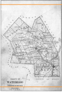
Waterloo County, created in 1853 and dissolved in 1973, was the forerunner of the Regional Municipality of Waterloo in Ontario, Canada. Situated on a subset of land within the Haldimand Tract, the traditional territory of the Attawandaron, Anishinaabe and Haudenosaunee peoples, Waterloo County consisted of five townships: Woolwich, Wellesley, Wilmot, Waterloo, and North Dumfries. The major population centres were Waterloo, Kitchener, Preston, Hespeler, Blair, and Doon in Waterloo township; Galt in North Dumfries; Elmira in Woolwich; and New Hamburg in Wilmot. All are now part of the Regional Municipality.
New York State Route 97 (NY 97) is a 70.53-mile-long (113.51 km) north–south scenic route in southern New York in the United States. It runs from U.S. Route 6 (US 6) and US 209 in Port Jervis to NY 17 in Hancock. Its most famous feature is the Hawk's Nest, a tightly winding section of the road along the Delaware River, located a few miles north of Port Jervis. NY 97 intersects NY 52 in Narrowsburg and indirectly connects to three Pennsylvania state highways due to its proximity to the state line.

Black Creek is a community on the eastern side of Vancouver Island, British Columbia, Canada. It is approximately 16 kilometres (9.9 mi) north of Courtenay. It is primarily an agricultural hamlet and bedroom community to Courtenay and Campbell River - approximately 20 kilometres (12 mi) to the north. It is part of Electoral Area C in the Comox Valley Regional District.
New York State Route 9N (NY 9N) is a north–south state highway in northeastern New York in the United States. It extends from an intersection with U.S. Route 9 (US 9), NY 29, and NY 50 in the city of Saratoga Springs to a junction with US 9 and NY 22 in the Clinton County hamlet of Keeseville. At 143.49 miles (230.92 km) in total length, NY 9N is the longest letter-suffixed route in the state. It is concurrent with its parent route for 1 mile (1.6 km) in the village of Lake George and for three blocks in the hamlet of Elizabethtown.
New York State Route 14A (NY 14A) is a north–south state highway located in the Finger Lakes region of New York in the United States. It extends for 35.99 miles (57.92 km) from an interchange with NY 14 in the Schuyler County town of Reading to an intersection with U.S. Route 20 (US 20) and NY 5 west of the Ontario County city of Geneva. In between, the two-lane route serves Yates County and the village of Penn Yan, located at the northeastern tip of Keuka Lake. Outside of Penn Yan, NY 14A traverses rural, rolling terrain dominated by farmland.
New York State Route 11B (NY 11B) is a state highway in northern New York in the United States. It provides a parallel, more southerly east–west route to U.S. Route 11 between US 11 in Potsdam and US 11, NY 30, and NY 37 in Malone. NY 11B serves both the Potsdam Municipal Airport and the riverside hamlet of Nicholville, where NY 11B meets NY 458. Aside from the two villages at each end of the route and the hamlet of Nicholville near the midpoint, NY 11B passes through rural, lightly populated areas, as does its parent to the north. In Malone, NY 11B overlaps NY 30 for one block in order to reconnect to US 11.

Girvin is a former village of 20 people in Saskatchewan, Canada. It is located midway between Regina and Saskatoon on Highway 11 between the towns of Davidson and Craik. The village was formally dissolved in 2005; its remaining population is now counted as part of the rural municipality of Arm River.
The Rural Municipality of Rhineland is a former rural municipality (RM) in the Canadian province of Manitoba. Since 1876, the area made up part of the Mennonite West Reserve. The R.M. of Rhineland was originally incorporated as a rural municipality on February 14, 1880 and later absorbed the neighbouring RM of Douglas in January 1891. It ceased on January 1, 2015 as a result of its provincially mandated amalgamation with the towns of Gretna and Plum Coulee to form the Municipality of Rhineland.

Blumenort is a local urban district in the Canadian province of Manitoba. It is located in the Rural Municipality of Hanover, just north of the city of Steinbach. It was founded in 1874 by Russian Mennonite farmers. Today, its economy is based on agriculture and the service industry.
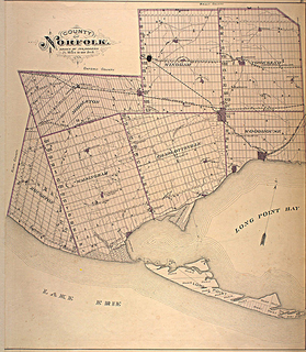
Norfolk County in the Canadian province of Ontario consists of a long list of communities. Its four designated population centres are Simcoe, Port Dover, Delhi, and Waterford.

The Rural Municipality of Mountain View No. 318 is a rural municipality (RM) in the Canadian province of Saskatchewan within Census Division No. 12 and SARM Division No. 6.
Skerry is a hamlet in the town of Brandon in Franklin County, New York, United States. It is located east of the Little Salmon River on Franklin County Highway 12 and Franklin County Highway 13. Skerry is 9 miles (14 km) southwest of Malone and 5 miles (8 km) southeast of West Bangor.

Reesor is a ghost town located in Cochrane District, Ontario, Canada, along Highway 11, named after its founder, Thomas Reesor.
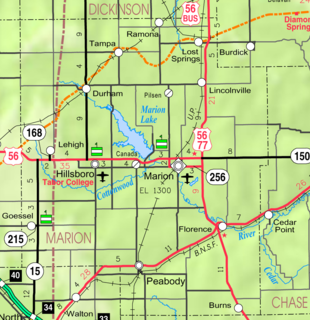
Gnadenau was a communal village of German-speaking Mennonite immigrants from Russia in Marion County, Kansas, United States. It is currently a ghost town that was located approximately 2 miles (3.2 km) southeast of Hillsboro. No buildings remain at this former community site. The Gnadenau Cemetery still exists.
References
- ↑ B2B-directory.ca. (n.d.). Retrieved November 17, 2017, from http://b2b-directory.ca/lloyd-farms-village-candle-company/l15323/
- ↑ David Hogue (President) @ Lloyd Farms & Village Candle Company. (n.d.). Retrieved November 17, 2017, from http://www.companylisting.ca/Lloyd_Farms_Village_Candle_Company/email.aspx?contact=31533
Coordinates: 49°48′18″N97°29′58″W / 49.80500°N 97.49944°W
Division No. 10, Manitoba (Whitehorse Plains) | ||
|---|---|---|
| Rural municipalities |  | |
| Unincorporated communities | ||
| | This Manitoba location article is a stub. You can help Wikipedia by expanding it. |