The Cree are a North American Indigenous people. They live primarily in Canada, where they form one of the country's largest First Nations.
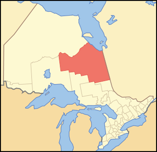
Cochrane District is a district and census division in Northeastern Ontario in the Canadian province of Ontario. It was created in 1921 from parts of Timiskaming and Thunder Bay districts.
Moose Factory is a community in the Cochrane District, Ontario, Canada. It is located on Moose Factory Island, near the mouth of the Moose River, which is at the southern end of James Bay. It was the first English-speaking settlement in lands now making up Ontario and the second Hudson's Bay Company post to be set up in North America after Fort Rupert. On the mainland, across the Moose River, is the nearby community of Moosonee, which is accessible by water taxi in the summer, ice road in the winter, and chartered helicopter in the off-season.
First Nations in Alberta are a group of people who live in the Canadian province of Alberta. The First Nations are peoples recognized as Indigenous peoples or Plains Indians in Canada excluding the Inuit and the Métis. According to the 2011 Census, a population of 116,670 Albertans self-identified as First Nations. Specifically there were 96,730 First Nations people with registered Indian Status and 19,945 First Nations people without registered Indian Status. Alberta has the third largest First Nations population among the provinces and territories. From this total population, 47.3% of the population lives on an Indian reserve and the other 52.7% live in urban centres. According to the 2011 Census, the First Nations population in Edmonton totalled at 31,780, which is the second highest for any city in Canada. The First Nations population in Calgary, in reference to the 2011 Census, totalled at 17,040. There are 48 First Nations or "bands" in Alberta, belonging to nine different ethnic groups or "tribes" based on their ancestral languages.
First Nations in Manitoba constitute of over 130,000 registered people, about 60% of whom live on reserve. There are 63 First Nations in the province and five indigenous linguistic groups. The languages are Nēhiyawēwin, Ojibwe, Dakota, Oji-Cree, and Dene.

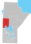
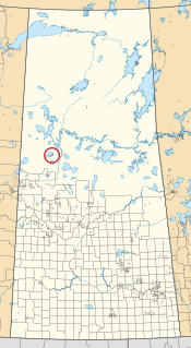
Division No. 17 is a census division in Alberta, Canada. It spans the central and northwest portions of northern Alberta and its largest urban community is the Town of Slave Lake. Division No. 17 is the largest census division in Alberta according to area and also has the lowest population density.
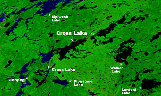
Cross Lake is the name of two closely related, adjoining but independent communities in the Canadian province of Manitoba. One of the Cross Lakes is the Cross Lake Indian Reserve of the Cross Lake First Nation where the main urban area is called Cross Lake. The other Cross Lake is on nearby provincial Crown land. The communities are located about 520 kilometres by air north of Winnipeg, and 120 kilometres by air south of Thompson. They are situated on the shores of the Nelson River where the river enters Cross Lake. An all-weather road, PR 374, connects the communities to PR 373 via the Kichi Sipi Bridge.

Moose Lake is a small community in Manitoba, Canada. It is located on the eastern edge of the Saskatchewan River Delta on the western shore of South Moose Lake about 74 km southeast of The Pas. Adjacent to the non-treaty community is a First Nations reserve, home to the Mosakahiken Cree Nation.
The Swampy Cree people, also known by their autonyms Néhinaw, Maskiki Wi Iniwak, Mushkekowuk,Maškékowak or Maskekon or by exonyms including West Main Cree,Lowland Cree, and Homeguard Cree, are a division of the Cree Nation occupying lands located in northern Manitoba, along the Saskatchewan River in northeastern Saskatchewan, along the shores of Hudson Bay and adjoining interior lands south and west as well as territories along the shores of Hudson and James Bay in Ontario. They are geographically and to some extent culturally split into two main groupings, and therefore speak two dialects of the Swampy Cree language, which is a "n-dialect":

Wahgoshig First Nation, formerly known as Abitibi-Ontario Band of Abitibi Indians or simply as Abitibi, is an Anishinaabe and Cree First Nation band governments whose reserve communities are located near Matheson in Cochrane District in northeastern Ontario, Canada. They have reserved for themselves the 7,770.1 hectares Abitibi Indian Reserve No. 70 on the south end of Lake Abitibi. In January 2008, the First Nation had 270 people registered with the nation, of which their on-reserve population was 121.
Canoe Lake 165 is an Indian reserve of the Canoe Lake Cree First Nation in the boreal forest of northern Saskatchewan, Canada. Its location is on Canoe Lake approximately thirty miles west of Beauval, within the ancient hunting grounds of the Woodland Cree. In the 2016 Canadian Census, it recorded a population of 912 living in 250 of its 273 total private dwellings. In the same year, its Community Well-Being index was calculated at 53 of 100, compared to 58.4 for the average First Nations community and 77.5 for the average non-Indigenous community. The reserve includes the settlement of Canoe Narrows.
Constance Lake First Nation is an Oji-Cree First Nations band government located on the shores of Constance Lake near Hearst, Cochrane District in northeastern Ontario, Canada. It is directly north of the community of Calstock along a continuation of Ontario Highway 663. Constance Lake First Nation is home to close to 1605 members of Cree and Ojibway with approximately 820 living on reserve. It may also be known as "Home of Sonny Sutherland". The reserves, Constance Lake 92 and English River 66, total 7,686 acres (3,110 ha) in size.

The Moose Cree First Nation is a Cree First Nation band government in northern Ontario, Canada. Their traditional territory is on the west side of James Bay. The nation has two reserves: Factory Island 1 ; and Moose Factory 68, a tract of land about 15 km upstream on the Moose River covering 168.82 square kilometres (65.18 sq mi).

Chapleau Cree First Nation is a Mushkegowuk Cree First Nation located by Chapleau Township, Sudbury District, Ontario, Canada. The First Nation have reserved for themselves the 108.1 hectares Chapleau 75 Indian Reserve and the 1,016.8 hectares Chapleau Cree Fox Lake Indian Reserve. As of 2019, their on-reserve population was 57 compared to 2011 with 79 and 2006 with 92.

Obedjiwan is a First Nations reserve and village on the north shore of Gouin Reservoir in the Mauricie region of Quebec, Canada. It belongs to the Atikamekw of Opitciwan band of the Atikamekw Nation.
Garden River, also known as Garden Creek, is an unincorporated community in northern Alberta, Canada within Wood Buffalo National Park. It is located on the north shore of the Peace River at the terminus of Garden River Road, an extension of Highway 58, approximately 190 km (120 mi) east of the Town of High Level. It is a First Nations community of the Little Red River Cree Nation.
The Mathias Colomb Cree Nation (MCCN) —also known as Mathias Colomb First Nation, Mathias Colomb (Cree) First Nation, and Pukatawagan/Mathias Colomb Cree Nation—is a remote First Nations community in northern Manitoba, located 210 km (130 mi) north of The Pas and 819 km (509 mi) northwest of Winnipeg, Manitoba.

The Tataskweyak Cree Nation is a First Nations band government whose primary community is located at Split Lake, Manitoba, on the Nelson River system. Despite its remote location, it is serviced by Provincial Road 280, which connects the community to Thompson.

The Sapotaweyak Cree Nation (SCN) is a First Nations band government whose reserves are located in northern Manitoba, north-east of Swan River, approximately 400 kilometres northwest of Winnipeg.
The Montreal Lake Cree Nation is a Woodland Cree First Nation in northern Saskatchewan. The administrative centre of the Montreal Lake Cree Nation is located in the community of Montreal Lake.