St. Theresa Point First Nation

Last updated
St. Theresa Point
St. Theresa Point 2.jpg
Canada Manitoba location map 2.svg
Red pog.svg
St. Theresa Point
Location of St. Theresa Point in Manitoba
Coordinates: 53°48′45″N94°55′05″W / 53.81250°N 94.91806°W / 53.81250; -94.91806
Country Canada
Province Manitoba
Region Northern
Government
  Type Band
  ChiefMarie A. Wood
   MLA Ian Bushie (Keewatinook)
   MP Niki Ashton (Churchill—Keewatinook Aski)
Area
  Land153.89 km2 (59.42 sq mi)
Elevation
250 m (820 ft)
Population
 (2016 [1] )
  Total3,262
  Density21.2/km2 (55/sq mi)
Time zone UTC-6 (CST)
  Summer (DST) UTC-5 (CDT)
St. Theresa Point First Nation
Band No. 298 [2]
Treaty Treaty 5
Province Manitoba
Land
Main reserveSt. Theresa Point
Other reserve(s)
  • Cantin Lake
  • Mukwa Narrows
Land area28.85 km2
Government
ChiefMarie A. Wood
Council size9
Tribal Council
Island Lake Tribal Council
Website
stpfirstnation.com

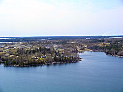
St. Theresa Point First Nation (Oji-Cree: Minithayinikam) is a First Nations community in northern Manitoba. It has 3 reserves in total, the largest and most populated of which is St. Theresa Point, which is bordered by the unorganized portion of Division No. 22, Manitoba, and by the Wasagamack First Nation.

Contents

The reserve is only accessible by airplane or winter ice roads (which continue north towards Garden Hill, and southwest towards Manigotagan, with a branch leading towards Berens River). The community is served by the nearby St. Theresa Point Airport. It has a local educational institution, St Theresa Point Regional Centre, with courses offered by the University College of the North and Assiniboine Community College.

Demographics

The community had a population of 2,871 in the Canada census of 2011 an increase of 9.1% from a 2006 population of 2,632. The median age was 20.1. The population density was 18.7 per km2 and the land area was 153.38 km2. There are 478 housing units within the community. [3]

St. Theresa Point First Nation

St. Theresa Point First Nation is the First Nations located at the center of St. Theresa Point. [4]

St. Theresa Point First Nation once belonged to the Island Lake band, [4] who, on 13 August 1909, became a signatory of Treaty 5. In 1969, Island Lake split into four separate communities with their own separate administrations: Garden Hill, Wasagamack, Red Sucker Lake, and St. Theresa Point First Nations. [5] Today, the 4 communities have a Tribal Council, called Island Lake Tribal Council, to collaborate on common interests. [5] [6]

In 2011, the Island Lake communities (including St. Theresa Point FN) had a combined population of 7,120. [3]

As of December 2014, the First Nation had a registered population of 4,069, out of which 3,795 lived on their own reserve. The First Nation has a Custom Electoral System and is governed by an elected Chief and eight councillors. Along with Island Lake Tribal Council, the First Nation is affiliated with Manitoba Keewatinohk Okimahkanak (MKO), Assembly of Manitoba Chiefs (AMC), and Crown–Indigenous Relations and Northern Affairs Canada. [4]

Territory

St. Theresa Point First Nation has three reserves: [6]

and meengwun

Notable people

Related Research Articles

First Nation Operated Schools in Manitoba and the rest of Canada are schools that are funded by the Government of Canada. In accordance with the Treaty arrangements between the federal government and most individual First Nations, First Nation Operated Schools must be administered by locally elected School boards, and operate outside the direct control of the local Chief and Band Council.

First Nations in Manitoba constitute of over 160,000 registered persons as of 2021, about 57% of whom live on reserve. Manitoba is second to Ontario in total on-reserve population and in total First Nation population.

Wasagamack First Nation is an Oji-Cree First Nation band government in Manitoba, Canada. As of December 2014 the registered population of the Wasagamack First Nation was 2,017, of which 1,823 lived on their own reserve.

<span class="mw-page-title-main">Garden Hill First Nation</span> Indian reserve in Manitoba, Canada

Garden Hill is the second largest of three reserves of the Island Lake region of Manitoba.

Mishkeegogamang First Nation is an Ojibway band government in the Canadian province of Ontario. Until 1993, the band was called the Osnaburgh First Nation, with various settlements at times being called New Osnaburgh, Osnaburgh House, or Osnaburgh.

There are several lakes named Mud Lake within the Canadian province of Alberta.

<span class="mw-page-title-main">Island Lake (Manitoba)</span>

Island Lake is a lake in northeastern Manitoba in Canada, near the Ontario border. The lake covers a total area of 1,223 square kilometres (472 sq mi), making it the 6th largest lake in the province. The lake is in the Hayes River drainage basin. The Island Lake River flows north from the northwest section of the lake into Gods Lake via Goose Lake and Beaver Lake. Gods Lake drains north through Gods River into the Hayes River.

<span class="mw-page-title-main">Island Lake, Manitoba</span> Unincorporated community in Manitoba, Canada

Island Lake is a small community in northeast Manitoba, Canada. The community consists of an archipelago near the north shore of Island Lake which includes the following islands: Red Sucker Lake, Garden Hill, Wasagamack, St Theresa point.

Red Sucker Lake is an Oji-Cree First Nation in Manitoba, Canada, located about 706 km (439 mi) northeast of Winnipeg. As of December 2021, the registered population was 1,178 of which 953 lived on their own reserve.

<span class="mw-page-title-main">Bonaparte Indian Band</span>

The Bonaparte Indian Band a.k.a. Bonaparte First Nation, is a member band of the Shuswap Nation Tribal Council of the Secwepemc (Shuswap) people.

The Skeetchestn Indian Band is a member of the Secwepemc (Shuswap) Nation, located in the Central Interior region of the Canadian province of British Columbia. Its main Indian reserve is located at Savona, British Columbia. The reserve was set up in the 1860s when the government of the then-Colony of British Columbia established an Indian reserve system. The Skeetchestn is a member government of the Shuswap Nation Tribal Council.

The Williams Lake First Nation is a First Nations government of the Secwepemc (Shuswap) Nation, located in the Cariboo region of the Central Interior region of the Canadian province of British Columbia, at the city of Williams Lake. It was created when the government of the then-Colony of British Columbia established an Indian reserve system in the 1860s. It is a member government of the Northern Shuswap Tribal Council. Its main Indian Reserve is Williams Lake Indian Reserve No. 1, a.k.a. "Sugarcane" or "The Cane" or "SCB".

The Kluskus First Nation is the band government of the Lhoosk’uz, a Dakelh people whose main reserve located on the Chilcotin Plateau 130 km west of the city of Quesnel, British Columbia, Canada. The First Nation is a member of the Carrier-Chilcotin Tribal Council, which includes both Tsilhqot'in and Carrier (Dakelh) communities.

<span class="mw-page-title-main">Lil'wat First Nation</span> First Nation band government

The Lil'wat First Nation, a.k.a. the Lil'wat Nation or the Mount Currie Indian Band, is a First Nation band government located in the southern Coast Mountains region of the Interior of the Canadian province of British Columbia. It is a member of the Lillooet Tribal Council, which is the largest grouping of band governments of the St'at'imc or Stl'atl'imx people. Other St'at'imc governments include the smaller In-SHUCK-ch Nation on the lower Lillooet River to the southwest, and the independent N'quatqua First Nation at the near end of Anderson Lake from Mount Currie, which is the main reserve of the Lil'wat First Nation, and also one of the largest Indian reserves by population in Canada.

<span class="mw-page-title-main">Carrot River (Saskatchewan)</span> River in Western Canada

Carrot River is a river in Western Canada in the north-eastern part Saskatchewan and the north-western part of Manitoba. The outlet of Wakaw Lake in Saskatchewan marks the beginning of the Carrot River and, from there, it flows north-east past several communities and Indian reserves until it joins the Saskatchewan River in the Cumberland Delta in Manitoba. The river's mouth is west and upstream of the Pasquia River and The Pas on the Saskatchewan River.

The Sayisi Dene are Chipewyan peoples, a Dene group, living in northern Manitoba. They are members of the Sayisi Dene First Nation, located at Tadoule Lake, and are notable for living a nomadic caribou-hunting and gathering existence. They are the most eastern of all the Dene peoples.

The Tahltan First Nation, also known as the Tahltan Indian Band, is a band government of the Tahltan people. Their main community and reserves are located at Telegraph Creek, British Columbia. Their language is the Tahltan language, which is an Athabaskan language also known as Nahanni, is closely related to Kaska and Dunneza. Their Indian and Northern Affairs Canada band number is 682. The Tahltan First Nation is joined with the Iskut First Nation in a combined tribal council-type organization known as the Tahltan Nation.

The Leq'á:mel First Nation, formerly known as Lakahahmen First Nation, is a First Nations band government whose community and offices are located in the area near Deroche, British Columbia in the Fraser Valley region in Canada, about 12 kilometres east of the District of Mission. They are a member government of the Sto:lo Nation Chiefs Council, which is one of two tribal councils of the Sto:lo.

Wasagamack or Waasagomach is a community in the Canadian province of Manitoba. It is a settlement of the Wasagamack First Nation located on the western shore of Island Lake on Waasagomach Bay north of St. Theresa Point. It is only accessible by boat across Island Lake, ice roads or by air. Wasagamack had a population of 1,411 in the 2011 Canadian census.

The Island Lake Tribal Council (ILTC), or Anishininew Okimawin - Island Lake Tribal Council, is a tribal council in northeastern Manitoba, Canada, representing 4 First Nations communities situated along Island and Red Sucker Lakes.

References

  1. "God's Lake Census Canada data". Census Canada . Retrieved 2018-06-20.
  2. "About Us".
  3. 1 2 "Canada Census 2011". 8 February 2012. Retrieved 2015-01-14.
  4. 1 2 3 "About Us". stpfn. Retrieved 2021-08-14.
  5. 1 2 "First Nation History". stpfn. Retrieved August 14, 2021.
  6. 1 2 "AANDC (Registered Population)". Crown–Indigenous Relations and Northern Affairs Canada . Government of Canada. Retrieved 2015-01-14.
  7. "Natural Resources Canada-Canadian Geographical Names (Cantin Lake )" . Retrieved 2015-01-07.
  8. "Natural Resources Canada-Canadian Geographical Names (Mukwa Narrows)" . Retrieved 2015-01-07.
  9. "Natural Resources Canada-Canadian Geographical Names (St. Theresa Point)" . Retrieved 2015-01-07.