Cross Lake, Manitoba

Last updated

Cross Lake
Cross Lake, Manitoba.jpg
Location of Cross Lake on Cross Lake
Canada Manitoba location map 2.svg
Red pog.svg
Cross Lake
Coordinates: 54°37′32″N97°46′48″W / 54.62556°N 97.78000°W / 54.62556; -97.78000
Country Canada
Province Manitoba
Census division 22
Elevation
207 m (679 ft)
Time zone UTC−5 (CST)
  Summer (DST) UTC−6 (CDT)

Cross Lake is a community in the Northern Region of the Canadian province of Manitoba, situated on the shores of the Nelson River where the river enters the namesake Cross Lake. An all-weather road, PR 374, connects the communities to PR 373 via the Kichi Sipi Bridge.

Contents

Although one population centre, it is politically divided into 4 entities:

History

In 1795, James Tate established a Hudson's Bay Company (HBC) fur-trade post on the southern end of Cross Lake, first called "X" Lake and then Apsley House in 1796. But in spring of that year, it was abandoned. It was re-established in 1849, but again closed a year later. [5]

In 1869, a HBC post reopened on the lake. In 1886 and 1887, the HBC built new facilities on the north side of the lake's narrows. [5] From circa 1885 to 1889, this post was also responsible for an outpost at Cross Portage. [6]

In 1959, the post became part of the HBC Northern Stores Department. HBC divested this department in 1987 to The North West Company, which still operates a Northern Store at Cross Lake. [5] [7]

In March 2016, First Nation officials in Cross Lake declared a state of emergency because of an epidemic of suicides. There had been "six suicides in the last two months and 140 attempts in the last two weeks alone", and band councilor Donnie McKay said the community "is traumatized and needs immediate help from the provincial and federal governments". [8]

Geography

The communities are situated on the eastern shores of Cross Island and Cross Lake. The lake is on the Nelson River north of Lake Winnipeg. It is long and narrow and extends 102 km (63 mi) east-northeast. The Nelson enters and leaves on the west side. The Minago River enters on the west. From the Minago a portage trail leads to Moose Lake and the Saskatchewan River. On the east side via the Walker River, Walker Lake and Kapaspwaypanik Lake the Kapaspwaypanik Portage leads to the Carrot River and Oxford Lake on the Hayes River. [9] [10]

It is located about 520 kilometres (320 mi) by air north of Winnipeg, and 120 kilometres (75 mi) by air south of Thompson.

Climate

Cross Lake has a subarctic climate (Koppen: Dfc), typical of Northern Manitoba. Temperatures in the summer are warm, whilst in the winter they are bitterly cold. [11]
Climate data for Cross Lake
MonthJanFebMarAprMayJunJulAugSepOctNovDecYear
Record high °C (°F)7.5
(45.5)
8.2
(46.8)
15
(59)
27.5
(81.5)
33.5
(92.3)
33.5
(92.3)
35.5
(95.9)
34
(93)
31.5
(88.7)
21
(70)
15.6
(60.1)
6
(43)
35.5
(95.9)
Average high °C (°F)−17.4
(0.7)
−12.1
(10.2)
−4.2
(24.4)
5.5
(41.9)
14
(57)
20.2
(68.4)
23.3
(73.9)
21.7
(71.1)
13.6
(56.5)
5.4
(41.7)
−5.5
(22.1)
−14.7
(5.5)
4.2
(39.6)
Average low °C (°F)−26.5
(−15.7)
−22.4
(−8.3)
−16.3
(2.7)
−6
(21)
2.7
(36.9)
9.4
(48.9)
12.8
(55.0)
11.6
(52.9)
5.1
(41.2)
−1.3
(29.7)
−12.2
(10.0)
−23
(−9)
−5.5
(22.1)
Record low °C (°F)−44
(−47)
−42
(−44)
−40
(−40)
−29.4
(−20.9)
−16
(3)
−2
(28)
3
(37)
−0.6
(30.9)
−6
(21)
−18.5
(−1.3)
−37.2
(−35.0)
−41.5
(−42.7)
−44
(−47)
Average precipitation mm (inches)17.3
(0.68)
16.5
(0.65)
16.6
(0.65)
18.4
(0.72)
42.6
(1.68)
68.6
(2.70)
69.7
(2.74)
67
(2.6)
53.5
(2.11)
33.4
(1.31)
23.2
(0.91)
25.6
(1.01)
452.3
(17.81)
Source: Environment Canada [12]

Demographics

In the 2021 Census of Population conducted by Statistics Canada, Cross Lake had a population of 521 living in 139 of its 162 total private dwellings, a change of

The adjoining reserves of Cross Lake 19 (population 1,751 in 2011 [13] ), Cross Lake 19A (population 1,889 in 2011 [14] ) and Cross Lake 19E (population 682 in 2011 [14] ) of the Cross Lake First Nation had a combined population of 7,622 in 2011.

Together these communities formed a population centre of 9,033 in 2017.

Notable people

Related Research Articles

<span class="mw-page-title-main">Northern Canada</span> Region of Canada

Northern Canada, colloquially the North or the Territories, is the vast northernmost region of Canada variously defined by geography and politics. Politically, the term refers to the three territories of Canada: Yukon, Northwest Territories and Nunavut. This area covers about 48 per cent of Canada's total land area, but has less than 0.5 per cent of Canada's population.

<span class="mw-page-title-main">Alberni-Clayoquot Regional District</span> Regional district in British Columbia, Canada

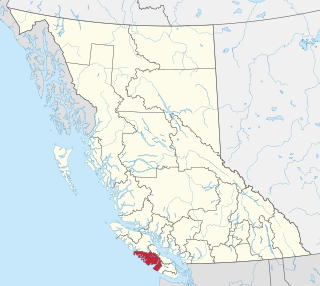
The Alberni–Clayoquot Regional District of British Columbia is located on west central Vancouver Island. Adjacent regional districts it shares borders with are the Strathcona and Comox Valley Regional Districts to the north, and the Nanaimo and Cowichan Valley Regional Districts to the east. The regional district offices are located in Port Alberni.

<span class="mw-page-title-main">Esquimalt</span> District municipality in British Columbia, Canada

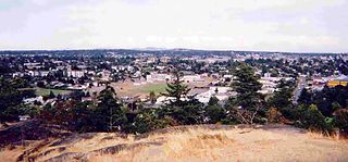
The Township of Esquimalt is a municipality at the southern tip of Vancouver Island, in British Columbia, Canada. It is bordered to the east by the provincial capital, Victoria, to the south by the Strait of Juan de Fuca, to the west by Esquimalt Harbour and Royal Roads, to the northwest by the New Songhees 1A Indian reserve and the town of View Royal, and to the north by a narrow inlet of water called the Gorge, across which is the district municipality of Saanich. It is almost tangential to Esquimalt 1 Indian Reserve near Admirals Road. It is one of the 13 municipalities of Greater Victoria and part of the Capital Regional District.

<span class="mw-page-title-main">Osoyoos</span> Town in British Columbia, Canada

Osoyoos is the southernmost town in the Okanagan Valley in British Columbia between Penticton and Omak. The town is 3.6 km (2.2 mi) north of the United States border with Washington state and is adjacent to the Osoyoos Indian reserve. The origin of the name Osoyoos was the word sw̓iw̓s meaning "narrowing of the waters" in the local Okanagan language (Syilx'tsn). The "O-" prefix is not indigenous in origin and was attached by settler-promoters wanting to harmonize the name with other place names beginning with O in the Okanagan region. There is one local newspaper, the Osoyoos Times.

<span class="mw-page-title-main">Squamish-Lillooet Regional District</span> Regional district in British Columbia, Canada

The Squamish-Lillooet Regional District is a quasi-municipal administrative area in British Columbia, Canada. It stretches from Britannia Beach in the south to Pavilion in the north. Lillooet, Pemberton, Whistler and Squamish are the four municipalities in the regional district. Its administrative offices are in the Village of Pemberton, although the district municipalities of Squamish and Whistler are larger population centres. The district covers 16,353.68 km² of land area.

<span class="mw-page-title-main">Morden, Manitoba</span> City in Manitoba, Canada

Morden is a city located in the Pembina Valley region of southern Manitoba, Canada near the United States border. It is about 11 km (6.8 mi) west of the neighbouring city of Winkler; together Morden and Winkler are often referred to as Manitoba's Twin Cities. Morden, which is surrounded by the Rural Municipality of Stanley, is the eighth largest and fastest-growing city in Manitoba. According to Statistics Canada, the city had a population of 9,929 in 2021, an increase of 14.5% from 2016, making it Manitoba's fastest growing city.

<span class="mw-page-title-main">Winnipeg Metropolitan Region</span> Metropolitan area in Manitoba, Canada

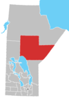
The Winnipeg Metropolitan Region is a metropolitan area in the Canadian province of Manitoba located in the Red River Valley in the southeast portion of the province of Manitoba, Canada. It contains the provincial capital of Winnipeg and 17 surrounding rural municipalities, cities, and towns.

<span class="mw-page-title-main">Rural Municipality of Hanover</span> Rural municipality in Manitoba, Canada

The Rural Municipality of Hanover is a rural municipality (RM) in southeastern Manitoba, Canada, located southeast of Winnipeg in Division No. 2.

<span class="mw-page-title-main">Mackenzie, British Columbia</span> District municipality in British Columbia, Canada

Mackenzie is a district municipality within the Fraser-Fort George Regional District in central British Columbia, Canada. The community is located at the south end of Williston Lake. The townsite, established by Alexandra Forest Industries and Cattermole Timber, was named for Sir Alexander MacKenzie (1764–1820).

<span class="mw-page-title-main">Little Grand Rapids</span> Unincorporated community in Manitoba, Canada

Little Grand Rapids is a community in east central Manitoba, Canada, near the Ontario border. It is located approximately 280 kilometers or 173 miles north-northeast from Winnipeg, Manitoba.

<span class="mw-page-title-main">Northern Rockies Regional Municipality</span> Regional district in British Columbia, Canada

The Northern Rockies Regional Municipality (NRRM), formerly the Northern Rockies Regional District (NRRD), and before that the Fort Nelson–Liard Regional District, is a municipality in northeastern British Columbia, Canada. Although portrayed as a regional municipality in its official name, and existing on the same administrative level as a regional district, it is actually classified as a district municipality. The NRRM's offices are located in Fort Nelson, formerly an incorporated town that amalgamated with the NRRD on February 6, 2009 to form the NRRM. With the Peace River Regional District as the southern part, it was the northern part of the Peace River-Liard Regional District, which was split into two on October 31, 1987.

<span class="mw-page-title-main">Regional District of North Okanagan</span> Regional district in British Columbia, Canada

The Regional District of North Okanagan (RDNO) is a regional district in the Canadian province of British Columbia, Canada. The Canada 2011 Census population was 81,237. The land area is 7,512.58 km². The regional district's head office is in the district municipality of Coldstream, although the largest population centre is its immediate neighbour, the city of Vernon.

<span class="mw-page-title-main">Houston, British Columbia</span> District municipality in British Columbia, Canada

Houston is a forestry, mining and tourism town in the Bulkley Valley of the Northern Interior of British Columbia, Canada. Its urban population is approximately 3600 people, with approximately 2000 in the surrounding rural area. It is known as the "steelhead capital" and it has the world's largest fly fishing rod. Houston's tourism industry is largely based on ecotourism and Steelhead Park, situated along Highway 16. Houston is named in honour of the pioneer newspaperman John Houston.

<span class="mw-page-title-main">Rural Municipality of St. Clements</span> Rural municipality in Manitoba, Canada

St. Clements is a rural municipality (RM) in Manitoba, Canada. It is located to the north-east of Winnipeg, stretching from East St. Paul and Birds Hill Provincial Park in the south to Lake Winnipeg and Grand Beach Provincial Park to the north. The Red River demarcates the western boundary of the municipality. St. Clements contains the communities of East Selkirk, and Lockport east of the Red River. It almost completely surrounds the Brokenhead 4 Indian reserve, with the exception of a small lakefront on Lake Winnipeg.

<span class="mw-page-title-main">Regional District of Fraser–Fort George</span> Regional district in British Columbia, Canada

The Regional District of Fraser–Fort George (RDFFG) is a regional district located in the Central Interior of British Columbia. It is bounded by the Alberta border to the east, the Columbia–Shuswap and Thompson–Nicola regional districts to the south and southeast, Cariboo Regional District to the southwest, the Regional District of Bulkley–Nechako to the west, and the Peace River Regional District to the north and northeast. As of the Canada 2011 Census, Fraser–Fort George had a population of 91,879 and a land area of 51,083.73 km2. The offices of the regional district are located at Prince George.

Lake Cowichan is a town located on the east end of Cowichan Lake and, by highway, is 27 kilometres (17 mi) west of Duncan, British Columbia. The town of Lake Cowichan was incorporated in 1944. The Cowichan River flows through the middle of the town. Cowichan River is designated as a Heritage River.

<span class="mw-page-title-main">Rural Municipality of Kelsey</span> Rural municipality in Manitoba, Canada

Kelsey is a Manitoban rural municipality embedded within the province's Northern Region. It consists of several disjoint parts. The largest part is Carrot Valley, located around and southwest of The Pas along the Carrot River, but the communities of Wanless and Cranberry Portage, located further north, are also part of the municipality. It is 867.64 km2 large. Also lying in the area around The Pas is the Opaskwayak Cree Nation Indian reserve.

<span class="mw-page-title-main">Berens River, Manitoba</span> Unincorporated community in Manitoba, Canada

Berens River is a community in Manitoba, Canada, along the eastern shore of Lake Winnipeg, at the mouth of the Berens River, which flows west from the Ontario headwaters. Together with the adjacent Berens River 13 reserve, it forms one a population centre collectively called Berens River. Both are served by the Berens River Airport.

<span class="mw-page-title-main">Fort St. James</span> District municipality in British Columbia, Canada

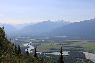
Fort St. James is a district municipality and former fur trading post in northern central British Columbia, Canada. It is located on the south-eastern shore of Stuart Lake in the Omineca Country, at the northern terminus of Highway 27, which connects to Highway 16 at Vanderhoof.

<span class="mw-page-title-main">Manigotagan, Manitoba</span> Unincorporated community in Manitoba, Canada

Manigotagan is a settlement in the Canadian province of Manitoba. It is located near the mouth of the Manigotagan River at Lake Winnipeg.

References

  1. 1 2 "Cross Lake, Northern community (NCM) Manitoba [Designated place] Census Profile, 2021 Census of Population". www12.statcan.gc.ca. Government of Canada - Statistics Canada. Retrieved 15 June 2023.
  2. "Cross Lake 19, Indian reserve (IRI) Manitoba [Census subdivision] Census Profile, 2021 Census of Population". www12.statcan.gc.ca. Government of Canada - Statistics Canada. Retrieved 15 June 2023.
  3. "Cross Lake 19A, Indian reserve (IRI) Manitoba [Census subdivision] Census Profile, 2021 Census of Population". www12.statcan.gc.ca. Government of Canada - Statistics Canada. Retrieved 15 June 2023.
  4. "Cross Lake 19E, Indian reserve (IRI) Manitoba [Census subdivision] Census Profile, 2021 Census of Population". www12.statcan.gc.ca. Government of Canada - Statistics Canada. Retrieved 15 June 2023.
  5. 1 2 3 "Hudson's Bay Company: Cross Lake". pam.minisisinc.com. Archives of Manitoba - Keystone Archives Descriptive Database. Retrieved 15 June 2023.
  6. "Hudson's Bay Company - Cross Portage". pam.minisisinc.com. Keystone Archives Descriptive Database, Archives of Manitoba. Retrieved 23 March 2023.
  7. "Northern/NorthMart Locator". www.northmart.ca. North West Company. Retrieved 15 June 2023.
  8. Jillian Taylor; Laura Glowacki (9 March 2016). "Pimicikamak declares state of emergency to deal with suicide crisis". cbc.ca. CBC News. Retrieved 15 June 2023.
  9. "Google Maps Distance Calculator" . Retrieved 7 January 2015.
  10. "Natural Resources Canada-Canadian Geographical Names (Cross Lake)" . Retrieved 29 August 2014.
  11. Canada, Environment and Climate Change (25 September 2013). "Canadian Climate Normals 1981-2010 Station Data – Climate – Environment and Climate Change Canada". climate.weather.gc.ca. Retrieved 24 May 2020.
  12. Environment CanadaCanadian Climate Normals 1971–2000. Retrieved 23 January 2010.
  13. "Population and dwelling count, 2011 Census". Statistics Canada. 14 February 2013. Retrieved 16 February 2013.
  14. 1 2 "Corrections and updates: Population and dwelling count amendments, 2011 Census". Statistics Canada. 14 February 2013. Retrieved 16 February 2013.