Lynn Lake is a town in the northwest region of Manitoba, Canada, approximately 1,071 km (665 mi) from Winnipeg. The town is the fourth-largest town in Manitoba in terms of land area. It is centred on the original urban community of Lynn Lake. The town was named after Lynn Smith, chief engineer of Sherritt Gordon Mines Ltd. There are many outfitters in the Lynn Lake area, offering services for most wilderness experiences, including sport fishing and bear and moose hunting.
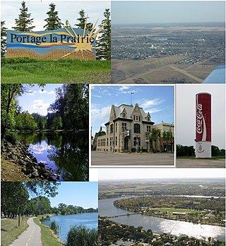
Portage la Prairie is a small city in the Central Plains Region of Manitoba, Canada. As of 2016, the population was 13,304 and the land area of the city was 24.68 square kilometres (9.53 sq mi).

Gillam is a town on the Nelson River in northern Manitoba, Canada. It is situated between Thompson and Churchill on the Hudson Bay Railway line.
Grandview is an unincorporated urban community in the Grandview Municipality within the Canadian province of Manitoba that held town status prior to January 1, 2015. It is located 45 kilometres west of the City of Dauphin along the Valley River.
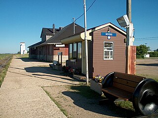
Rivers is an unincorporated urban community in the Riverdale Municipality within the Canadian province of Manitoba. It is located 40 kilometres (25 mi) northwest of Brandon, 473 metres (1,552 ft) above sea level. It is within the Westman Region. Agriculture, health and related businesses provide income for the community and area. Rivers has a population of 1,257 people in the 2016 census.

Baldur is an unincorporated community recognized as a local urban district in the Canadian province of Manitoba, located in the Rural Municipality of Argyle. Baldur is the largest community of the municipality, which is in southwestern Manitoba between Brandon and Portage la Prairie. The community is named after the Norse god Baldur.

Carberry is a town in southwestern Manitoba, Canada. It is situated 3 kilometres (1.9 mi) south of the Trans-Canada Highway on Highway 5 in the Municipality of North Cypress – Langford, and has a population of 1,818 people.
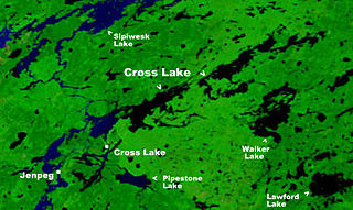
Cross Lake is a community in the Northern Region of the Canadian province of Manitoba, situated on the shores of the Nelson River where the river enters the namesake Cross Lake. An all-weather road, PR 374, connects the communities to PR 373 via the Kichi Sipi Bridge.
Erickson is an unincorporated urban community in the Municipality of Clanwilliam – Erickson within the Canadian province of Manitoba that held town status prior to 1 January 2015. It is located on Highway 10 on 32-17-18W in south central Manitoba. The main industry of Erickson is agriculture.
Mystery Lake is a local government district (LGD) in northern Manitoba. It surrounds the city of Thompson, although most of its territory lies to the southwest and south of the city. It is named after Mystery Lake, a lake located in the northeast section of the LGD, northeast of Thompson.
Starbuck is a community in Manitoba on the La Salle River, and is located within the Rural Municipality of Macdonald.
Pikwitonei is a community in Northern Region of Manitoba, Canada. It is located approximately 47 km (29.2 mi) from Thompson. The community is served by Via Rail at the Pikwitonei railway station.
Powerview-Pine Falls is a town in the Canadian province of Manitoba, with a population of 1,314 at the 2011 census, up 1.54% from 1,294 at the 2006 census and down 7.57% from 1,400 during the 2001 census.

Sherridon, Manitoba is an unincorporated community in Manitoba, Canada.
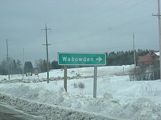
Wabowden is a community in northern Manitoba. It is situated on Provincial Trunk Highway No. 6, which is the main route between Thompson and the provincial capital, Winnipeg.
Camsell Portage is a northern settlement of 5 people, located on the north-central shore of Lake Athabasca. The northern settlement is an unincorporated community in the Northern Saskatchewan Administration District.

Armstrong is a rural municipality in the province of Manitoba in Western Canada. It lies in the southern area of the Interlake and was named after James William Armstrong, a Manitoba politician.
Woodlands is a rural municipality (RM) in the province of Manitoba in Western Canada. It lies in the southern part of the Interlake and is named for the community of Woodlands, which itself is named for the wooded lands of the area.

Kelsey is a Manitoban rural municipality embedded within the province's Northern Region. It consists of several disjoint parts. The largest part is Carrot Valley, located around and southwest of The Pas along the Carrot River, but the communities of Wanless and Cranberry Portage, located further north, are also part of the municipality. It is 867.64 km2 large. Also lying in the area around The Pas is the Opaskwayak Cree Nation Indian reserve.
Plumas is an unincorporated community recognized as a local urban district located in the Municipality of WestLake – Gladstone, in the Canadian province of Manitoba. Plumas is roughly 70 km northwest of Portage la Prairie, Manitoba, and about 150 km northwest of the provincial capital, Winnipeg.