Manigotagan, Manitoba

Last updated

Manigotagan
Unincorporated community
762 Manigotagan, Manitoba.svg
Canada Manitoba location map 2.svg
Red pog.svg
Manigotagan
Coordinates: 51°06′32″N96°18′17″W / 51.10889°N 96.30472°W / 51.10889; -96.30472
CountryCanada
Province Manitoba
Census division Division No. 19
Census subdivision Unorg. Div. No. 19
Area
[1]
  Land37.06 km2 (14.31 sq mi)
Population
 (2021) [1]
  Total173
Time zone UTC-6 (CST)
  Summer (DST) UTC-5 (CDT)
Area code(s) 204, 431, and 584

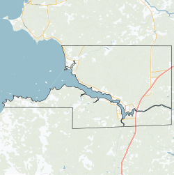
Manigotagan is a settlement in the Canadian province of Manitoba. [2] [3] It is located near the mouth of the Manigotagan River at Lake Winnipeg.

Contents

History

From circa 1887 to circa 1893, the Hudson's Bay Company operated a fur trade outpost here, called Bad Throat Post, and functioned as an outpost for Fort Alexander. The exact date that it was abandoned is unknown. [4]

Demographics

In the 2021 Census of Population conducted by Statistics Canada, Manigotagan had a population of 173 living in 69 of its 273 total private dwellings, a change of

Historical census populations – Manigotagan, Manitoba
YearPop.±%
1985 230    
1991 197−14.3%
1996 173−12.2%
2001 192+11.0%
YearPop.±%
2006 191−0.5%
2011 213+11.5%
2016 176−17.4%
2021 173−1.7%
Population count for 2016 based on revised count from 2021.
Source: Statistics Canada, Government of Manitoba [6]

Related Research Articles

<span class="mw-page-title-main">Columbia-Shuswap Regional District</span> Regional district in British Columbia, Canada

The Columbia–Shuswap Regional District is a regional district in the Canadian province of British Columbia, located in the Southern Interior region on the Trans-Canada Highway between Vancouver and Calgary, Alberta. The regional district borders the Province of Alberta across the Rocky Mountains.

<span class="mw-page-title-main">Gillam, Manitoba</span> Town in Manitoba, Canada

Gillam is a town on the Nelson River in northern Manitoba, Canada. It is situated between Thompson and Churchill on the Hudson Bay Railway line.

<span class="mw-page-title-main">Little Grand Rapids</span> Unincorporated community in Manitoba, Canada

Little Grand Rapids is a community in east central Manitoba, Canada, near the Ontario border. It is located approximately 280 kilometers or 173 miles north-northeast from Winnipeg, Manitoba.

<span class="mw-page-title-main">Rural Municipality of St. Andrews</span> Rural municipality in Manitoba, Canada

St. Andrews is a rural municipality (RM) in Manitoba, Canada. It lies west of the Red River; its southern border is approximately 8 kilometres (5.0 mi) north of Winnipeg.

Brochet is an unincorporated community located in Northern Manitoba on the northern shore of Reindeer Lake near the Saskatchewan border; it is designated as a northern community.

<span class="mw-page-title-main">Cross Lake, Manitoba</span> Place in Manitoba, Canada

Cross Lake is a community in the Northern Region of the Canadian province of Manitoba, situated on the shores of the Nelson River where the river enters the namesake Cross Lake. An all-weather road, PR 374, connects the communities to PR 373 via the Kichi Sipi Bridge.

<span class="mw-page-title-main">Rural Municipality of St. Clements</span> Rural municipality in Manitoba, Canada

St. Clements is a rural municipality (RM) in Manitoba, Canada. It is located to the north-east of Winnipeg, stretching from East St. Paul and Birds Hill Provincial Park in the south to Lake Winnipeg and Grand Beach Provincial Park to the north. The Red River demarcates the western boundary of the municipality. St. Clements contains the communities of East Selkirk, and Lockport east of the Red River. It almost completely surrounds the Brokenhead 4 Indian reserve, with the exception of a small lakefront on Lake Winnipeg.

<span class="mw-page-title-main">Sheshatshiu</span> Indian reserve in Newfoundland and Labrador, Canada

Sheshatshiu is an Innu federal reserve and designated place in the Canadian province of Newfoundland and Labrador. The reserve is approximately 40 kilometres (25 mi) north of Happy Valley-Goose Bay. Some references may spell the community's name as Sheshatshit, the t spelling is more traditional in the Innu-aimun language, but the u is used more commonly in English to avoid inappropriate connotations. The name means "a narrow place in the river".

Puvirnituq is a northern village in Nunavik, on the Povungnituk River near its mouth on Hudson Bay in northern Quebec, Canada. Its population was 2,129 as of the 2021 Canadian census.

<span class="mw-page-title-main">Rural Municipality of Macdonald</span> Rural Municipality in southern Manitoba

Macdonald is a rural municipality lying adjacent to the southwest side of Winnipeg, Manitoba, Canada. It is part of the Winnipeg Metro Region, but is not part of the smaller Winnipeg census metropolitan area. Macdonald's population as of the 2016 census was 7,162.

Powerview-Pine Falls is a town in the Canadian province of Manitoba, with a population of 1,314 at the 2011 census, up 1.54% from 1,294 at the 2006 census and down 7.57% from 1,400 during the 2001 census.

<span class="mw-page-title-main">Rapid City, Manitoba</span> Local urban district in Manitoba, Canada

Rapid City is an unincorporated community recognized as a local urban district that also once held town status in southwest Manitoba, Canada within the Rural Municipality of Oakview. It is located about 30 km north of Brandon. Rapid City is a farming community that is developed on the banks of the Little Saskatchewan River. The dam and reservoir in Rapid City were built by the province in 1961, the reservoir stores 200 acre-feet (250,000 m3) and provides a water supply and recreational facility for the community.

<span class="mw-page-title-main">Wabowden</span> Place in Manitoba, Canada

Wabowden is a community in northern Manitoba. It is situated on Provincial Trunk Highway No. 6, which is the main route between Thompson and the provincial capital, Winnipeg.

<span class="mw-page-title-main">Bissett, Manitoba</span> Community in Manitoba, Canada

Bissett is a community situated on Rice Lake in the southeastern region of Manitoba, Canada, classified as a northern community and designated place. Located two and a half hours northeast of Winnipeg on Provincial Road 304, Bissett is an entry point to Nopiming Provincial Park.

<span class="mw-page-title-main">Sioux Narrows-Nestor Falls</span> Township in Ontario, Canada

Sioux Narrows-Nestor Falls is a township in the Canadian province of Ontario, located in the Kenora District. It is located on the eastern shores of Lake of the Woods along Ontario Highway 71.

<span class="mw-page-title-main">Rural Municipality of Stanley</span> Rural municipality in Manitoba, Canada

Stanley is a rural municipality (RM) in the province of Manitoba in Western Canada. It is located in the southern part of the province, along its border with the state of North Dakota in the United States. Since 1876, the area made up part of the Mennonite West Reserve. The municipality has a population of 8,969 as of the 2016 Canada Census. The cities of Winkler and Morden lie geographically within the municipality but are separate urban municipalities.

Gunn is a hamlet in Alberta, Canada within Lac Ste. Anne County. It is located west of the junction of Highway 43 and Highway 33 on the northeast shore of Lac Ste. Anne. It is approximately 58 kilometres (36 mi) northwest of Edmonton and has an elevation of 740 metres (2,430 ft).

<span class="mw-page-title-main">Berens River, Manitoba</span> Unincorporated community in Manitoba, Canada

Berens River is a community in Manitoba, Canada, along the eastern shore of Lake Winnipeg, at the mouth of the Berens River, which flows west from the Ontario headwaters. Together with the adjacent Berens River 13 reserve, it forms one a population centre collectively called Berens River. Both are served by the Berens River Airport.

Meadow Portage is a community in the Canadian province of Manitoba.

Laurier is an unincorporated urban community in the Rural Municipality of Ste. Rose, Manitoba, Canada. It is located on Highway 480, 3.2 km (2.0 mi) west of Highway 5, between the community of McCreary to the south and the community of Ste. Rose du Lac to the north.

References

  1. 1 2 "Manigotagan, Northern community (NCM) Manitoba [Designated place] Census Profile, 2021 Census of Population". www12.statcan.gc.ca. Government of Canada - Statistics Canada. Retrieved 5 May 2023.
  2. "Geographical Names" (Esri shapefile). Manitoba Land Initiative. Retrieved April 18, 2014.
  3. "Manigotagan". Geographical Names Data Base . Natural Resources Canada . Retrieved 5 May 2023.
  4. "Hudson's Bay Company - Bad Throat Post". pam.minisisinc.com. Archives of Manitoba - Keystone Archives Descriptive Database. Retrieved 5 May 2023.
  5. "Population and dwelling counts: Canada and designated places". Statistics Canada. February 9, 2022. Retrieved Sep 3, 2022.
  6. "Manigotagan community profile" (PDF). www.gov.mb.ca. Government of Manitoba. March 2011. Retrieved 8 May 2023.