Berens River, Manitoba

Last updated

Berens River
Unincorporated community
744 Berens River, Manitoba.svg
Canada Manitoba location map 2.svg
Red pog.svg
Berens River
Coordinates: 52°21′55″N97°01′45″W / 52.3653°N 97.0292°W / 52.3653; -97.0292
CountryCanada
Province Manitoba
Census division Division No. 19
Census subdivision Unorg. Div. No. 19
Area
[1]
  Land5.12 km2 (1.98 sq mi)
Population
 (2020) [1]
  Total71
  Density13.9/km2 (36/sq mi)
Time zone UTC-6 (CST)
  Summer (DST) UTC-5 (CDT)
Area code(s) 204, 431, and 584

Berens River is a community in Manitoba, Canada, along the eastern shore of Lake Winnipeg, at the mouth of the Berens River, which flows west from the Ontario headwaters. Together with the adjacent Berens River 13 reserve, it forms one a population centre collectively called Berens River. Both are served by the Berens River Airport.

Contents

Prior to 2017, the community was accessible only by winter road, boat, or airplane. Road construction of an all-weather road from Bloodvein, connecting Berens River to the provincial road system, was completed in December 2017, linking the two communities to Provincial Road 304. [2] [3]

The First Nation and fur trade community there was officially started in the 19th century, but the spot was a traditional hunting and fishing area for thousands of years.

History

The first Hudson's Bay Company (HBC) fur-trade post at the mouth of the Berens River was established in the winter of 1814, which was named after Joseph Berens, HBC governor from 1812 to 1822 (it was also spelled as Beren's River and Berings River). This post lasted only 2 years. It was reestablished as an outpost of the HBC post at the Pigeon River in 1821. In the fall of 1824, it became a full post again. [4]

In 1842, a new warehouse was built and the post served as a transshipment point and to protect the trade at Little Grand Rapids, located about 140 kilometres (90 mi) upstream of the Berens River. [4]

In the 1930s, the Berens River Post operated an outpost at Poplar River. In 1959, the post became part of the HBC Northern Stores Department. HBC divested this department in 1987 to The North West Company, which still operates a Northern Store in Berens River First Nation. [4] [5]

Demographics

In the 2021 Census of Population conducted by Statistics Canada, Berens River had a population of 71 living in 21 of its 47 total private dwellings, a change of

According to the 2011 Canada Census, the bordering Berens River 13 reserve of the Berens River First Nation had a population of 1,028. [6]

Historical census populations – Berens River, Manitoba
YearPop.±%
2006 153    
2011 111−27.5%
2016 135+21.6%
2021 71−47.4%
Population figures based on revised counts.
Source: Statistics Canada

Climate

Berens River experiences a humid continental climate (Dfb). The highest temperature ever recorded in Berens River was 40.0 °C (104 °F) on 11 July 1936. [7] The coldest temperature ever recorded was −47.2 °C (−53 °F) on 28 December 1933. [8]

Climate data for Berens River, 1981−2010 normals, extremes 1905−present
MonthJanFebMarAprMayJunJulAugSepOctNovDecYear
Record high °C (°F)7.1
(44.8)
10.0
(50.0)
21.9
(71.4)
28.9
(84.0)
32.2
(90.0)
39.4
(102.9)
40.0
(104.0)
35.6
(96.1)
32.2
(90.0)
28.3
(82.9)
20.6
(69.1)
8.3
(46.9)
40.0
(104.0)
Mean daily maximum °C (°F)−13.8
(7.2)
−10.4
(13.3)
−3.1
(26.4)
7.0
(44.6)
14.8
(58.6)
20.8
(69.4)
23.3
(73.9)
22.1
(71.8)
15.8
(60.4)
7.4
(45.3)
−2.5
(27.5)
−10.3
(13.5)
5.9
(42.6)
Daily mean °C (°F)−18.9
(−2.0)
−16.2
(2.8)
−9.2
(15.4)
1.1
(34.0)
8.6
(47.5)
14.9
(58.8)
17.7
(63.9)
16.5
(61.7)
10.6
(51.1)
3.2
(37.8)
−6.5
(20.3)
−15.0
(5.0)
0.6
(33.1)
Mean daily minimum °C (°F)−23.9
(−11.0)
−22.0
(−7.6)
−15.3
(4.5)
−4.8
(23.4)
2.5
(36.5)
8.9
(48.0)
12.1
(53.8)
10.8
(51.4)
5.5
(41.9)
−1.0
(30.2)
−10.4
(13.3)
−19.7
(−3.5)
−4.8
(23.4)
Record low °C (°F)−46.7
(−52.1)
−45.0
(−49.0)
−42.9
(−45.2)
−34.4
(−29.9)
−17.8
(0.0)
−6.1
(21.0)
−2.8
(27.0)
−2.8
(27.0)
−9.4
(15.1)
−18.9
(−2.0)
−36.8
(−34.2)
−47.2
(−53.0)
−47.2
(−53.0)
Average precipitation mm (inches)17.9
(0.70)
12.3
(0.48)
23.7
(0.93)
23.4
(0.92)
45.8
(1.80)
60.4
(2.38)
52.2
(2.06)
72.2
(2.84)
63.4
(2.50)
47.3
(1.86)
31.2
(1.23)
19.9
(0.78)
469.8
(18.50)
Average rainfall mm (inches)0.1
(0.00)
0.9
(0.04)
7.8
(0.31)
17.0
(0.67)
43.7
(1.72)
60.4
(2.38)
52.2
(2.06)
72.2
(2.84)
63.2
(2.49)
35.4
(1.39)
8.2
(0.32)
0.3
(0.01)
361.3
(14.22)
Average snowfall cm (inches)20.7
(8.1)
13.3
(5.2)
17.6
(6.9)
6.7
(2.6)
2.2
(0.9)
0.0
(0.0)
0.0
(0.0)
0.0
(0.0)
0.3
(0.1)
13.0
(5.1)
26.7
(10.5)
22.7
(8.9)
123.1
(48.5)
Average precipitation days (≥ 0.2 mm)10.39.39.111.211.511.29.78.65.97.312.612.1118.8
Mean monthly sunshine hours 89.8123.2173.2222.0274.9277.9257.5269.7161.1107.560.369.02,086.1
Percent possible sunshine 35.044.247.253.356.555.551.159.242.232.522.828.644.0
Source: Environment Canada [9] [10] [11]

Related Research Articles

<span class="mw-page-title-main">Hudson Bay</span> Large body of saltwater in northeastern Canada

Hudson Bay, sometimes called Hudson's Bay, is a large body of saltwater in northeastern Canada with a surface area of 1,230,000 km2 (470,000 sq mi). It is located north of Ontario, west of Quebec, northeast of Manitoba and southeast of Nunavut, but politically entirely part of Nunavut. It is an inland marginal sea of the Arctic Ocean. It drains a very large area, about 3,861,400 km2 (1,490,900 sq mi), that includes parts of southeastern Nunavut, Alberta, Saskatchewan, Ontario, Quebec, all of Manitoba, and parts of the U.S. states of North Dakota, South Dakota, Minnesota, and Montana. Hudson Bay's southern arm is called James Bay.

<span class="mw-page-title-main">Tulita</span> Hamlet in Northwest Territories, Canada

Tulita, which in Slavey means "where the rivers or waters meet," is a hamlet in the Sahtu Region of the Northwest Territories, Canada. It was formerly known as Fort Norman, until 1 January 1996. It is located at the junction of the Great Bear River and the Mackenzie River; the Bear originates at Great Bear Lake adjacent to Deline.

<span class="mw-page-title-main">Moosonee</span> Town in Ontario, Canada

Moosonee is a town in northern Ontario, Canada, on the Moose River approximately 19 km (12 mi) south of James Bay. It is considered to be "the Gateway to the Arctic" and has Ontario's only saltwater port. Nearby on Moose Factory Island is the community of Moose Factory to which it is connected by water taxi in the summer and ice road in the winter.

<span class="mw-page-title-main">Athabasca, Alberta</span> Town in Alberta, Canada

Athabasca, originally named Athabasca Landing, is a town in northern Alberta, Canada. It is located 145 km (90 mi) north of Edmonton at the intersection of Highway 2 and Highway 55, on the banks of the Athabasca River. It is the centre of Athabasca County. It was known as Athabasca Landing prior to August 4, 1913.

<span class="mw-page-title-main">Kuujjuaq</span> Northern village municipality in Quebec, Canada

Kuujjuaq, formerly known as Fort Chimo and by other names, is a former Hudson's Bay Company outpost at the mouth of the Koksoak River on Ungava Bay that has become the largest northern village in the Nunavik region of Quebec, Canada. It is the administrative capital of the Kativik Regional Government. Its population was 2,668 as of the 2021 census.

<span class="mw-page-title-main">Fort Smith, Northwest Territories</span> Town in Northwest Territories, Canada

Fort Smith is a town in the South Slave Region of the Northwest Territories (NWT), Canada. It is located in the southeastern portion of the Northwest Territories, on the Slave River and adjacent to the Alberta border along the 60th parallel north.

<span class="mw-page-title-main">Moose Factory</span> Place in Ontario, Canada

Moose Factory is a community in the Cochrane District, Ontario, Canada. It is located on Moose Factory Island, near the mouth of the Moose River, which is at the southern end of James Bay. It was the first English-speaking settlement in lands now making up Ontario and the second Hudson's Bay Company post to be set up in North America after Fort Rupert. On the mainland, across the Moose River, is the nearby community of Moosonee, which is accessible by water taxi in the summer, ice road in the winter, and chartered helicopter in the off-season.

<span class="mw-page-title-main">Cumberland House, Saskatchewan</span> Village in Saskatchewan, Canada

Cumberland House is a community in Census Division No. 18 in northeast Saskatchewan, Canada on the Saskatchewan River. It is the oldest community in Saskatchewan and has a population of about 2,000 people. Cumberland House Provincial Park, which provides tours of an 1890s powder house built by the Hudson's Bay Company, is located nearby.

<span class="mw-page-title-main">Little Grand Rapids</span> Unincorporated community in Manitoba, Canada

Little Grand Rapids is a community in east central Manitoba, Canada, near the Ontario border. It is located approximately 280 kilometers or 173 miles north-northeast from Winnipeg, Manitoba.

<span class="mw-page-title-main">Fort Good Hope</span> Charter Community in Northwest Territories, Canada

Fort Good Hope, is a charter community in the Sahtu Region of the Northwest Territories, Canada. It is located on a peninsula between Jackfish Creek and the east bank of the Mackenzie River, about 145 km (90 mi) northwest of Norman Wells.

<span class="mw-page-title-main">Norway House</span> Population centre in Manitoba, Canada

Norway House is a population centre of over 5,000 people, some 30 km (19 mi) north of Lake Winnipeg, on the bank of the eastern channel of Nelson River, in the province of Manitoba, Canada. The population centre shares the name Norway House with the northern community of Norway House and Norway House 17, a First Nation reserve of the Norway House Cree Nation. Thus, Norway House has both a Chief and a Mayor.

<span class="mw-page-title-main">Cross Lake, Manitoba</span> Place in Manitoba, Canada

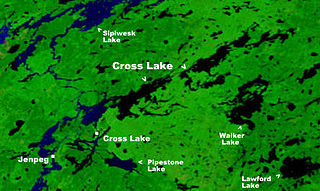
Cross Lake is a community in the Northern Region of the Canadian province of Manitoba, situated on the shores of the Nelson River where the river enters the namesake Cross Lake. An all-weather road, PR 374, connects the communities to PR 373 via the Kichi Sipi Bridge.

<span class="mw-page-title-main">Grand Rapids, Manitoba</span> Town in Manitoba, Canada

Grand Rapids is a town in Manitoba, Canada, on the northwestern shore of Lake Winnipeg where the Saskatchewan River enters the lake. As the name implies, the river had a significant drop at this point. In modern days, a large hydroelectric plant has been built there. Cedar Lake, a short distance upriver, provides a natural water source for the plant. Provincial Trunk Highway 6, the region's primary roadway, crosses the Saskatchewan River at the Grand Rapids Bridge.

South Indian Lake is an Indian settlement located on the southeast shore of Southern Indian Lake in northern Manitoba, Canada, about 130 km (81 mi) north of the city of Thompson by air. It had a population of 981 in 2016, and is the main settlement of the O-Pipon-Na-Piwin Cree Nation, a First Nations band government.

The Berens River is a river in the provinces of Manitoba and Ontario, Canada. It flows west from an unnamed lake in Kenora District, Ontario, and discharges its waters into Lake Winnipeg near the community and First Nation of Berens River, Manitoba. The river has a number of lakes along its course, and many rapids.

<span class="mw-page-title-main">Division No. 19, Manitoba</span> Census division in Manitoba, Canada

Division No. 19, also informally known as North East Manitoba, is a census division within the Province of Manitoba, Canada. Unlike in some other provinces, census divisions do not reflect the organization of local government in Manitoba. These areas exist solely for the purposes of statistical analysis and presentation; they have no government of their own.

<span class="mw-page-title-main">Bloodvein First Nation</span> First Nations community

The Bloodvein First Nation is a First Nations community located on the east side of Lake Winnipeg, along the Bloodvein River in Manitoba, Canada. As of 2019, the community had a population of 1,176.

<span class="mw-page-title-main">Gull Bay First Nation</span> Indian reserve in Ontario, Canada

Gull Bay First Nation or Kiashke Zaaging Anishinaabek is an Anishinaabe (Ojibway) First Nation band government located in Thunder Bay District in northwestern Ontario, Canada. It is approximately 175 kilometres (109 mi) north of Thunder Bay, Ontario on Highway 527 on the western shore of Lake Nipigon. As of May 2010, the First Nation had a registered population of 1,149 people, including an on-Reserve population of 328.

<span class="mw-page-title-main">Délı̨nę</span> Charter Community in Northwest Territories, Canada

The Charter Community of Délı̨nę is located in the Sahtu Region of the Northwest Territories, Canada, on the western shore of Great Bear Lake and is 544 km (338 mi) northwest of Yellowknife. Délı̨nę means "where the waters flow", a reference to the headwaters of the Great Bear River, Sahtúdé. It is the only settlement on the shores of Great Bear Lake as Fort Confidence was last used in the 1800s and Port Radium closed in 1982.

<span class="mw-page-title-main">Manigotagan, Manitoba</span> Unincorporated community in Manitoba, Canada

Manigotagan is a settlement in the Canadian province of Manitoba. It is located near the mouth of the Manigotagan River at Lake Winnipeg.

References

  1. 1 2 3 "Berens River, Northern community (NCM) Manitoba [Designated place] Census Profile, 2021 Census of Population". www12.statcan.gc.ca. Government of Canada - Statistics Canada. Retrieved May 16, 2023.
  2. "New all-weather road linking Berens River, Bloodvein to highways will open up economic opportunities: mayor". CBC News. December 12, 2017. Retrieved August 3, 2021.
  3. "Berens River all-season road opens in Manitoba". ReNew Canada. December 13, 2017. Retrieved August 3, 2021.
  4. 1 2 3 "Hudson's Bay Company: Berens River". pam.minisisinc.com. Archives of Manitoba - Keystone Archives Descriptive Database. Retrieved May 16, 2023.
  5. "Northern/NorthMart Locator". www.northmart.ca. North West Company. Retrieved May 16, 2023.
  6. "2011 Census Statistics Canada" . Retrieved April 2, 2013.
  7. "Daily Data Report for July 1936". Environment Canada. Retrieved November 17, 2016.
  8. "Daily Data Report for December 1933". Environment Canada. Retrieved November 17, 2016.
  9. "Calculation Information for 1981 to 2010 Canadian Normals Data". Environment Canada. Archived from the original on March 4, 2016. Retrieved October 24, 2014.
  10. "Berens River". Environment Canada. Retrieved November 17, 2016.
  11. "Berens River CS". Environment Canada. Retrieved November 17, 2016.