
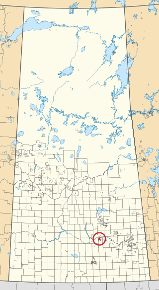
Gordon 86 is a Cree Indian reserve in Saskatchewan, Canada located about 61 kilometres (38 mi) north-west of Fort Qu'Appelle. Also known as the George Gordon Reserve, it is one of three territories of the George Gordon First Nation, as arranged by the signing of Treaty 4. The reserve has an area of 14,438.3 hectares. In the 2016 Canadian Census, it recorded a population of 837 living in 218 of its 238 total private dwellings. In the same year, its Community Well-Being index was calculated at 52 of 100, compared to 58.4 for the average First Nations community and 77.5 for the average non-Indigenous community. It is almost completely surrounded by the rural municipality of Touchwood No. 248.
Ahtahkakoop 104 is an Indian reserve of the Ahtahkakoop Cree Nation in Saskatchewan. It is about 72 kilometres (45 mi) northwest of Prince Albert. In the 2016 Canadian Census, it recorded a population of 1,472 living in 386 of its 424 total private dwellings. In the same year, its Community Well-Being index was calculated at 46 of 100, compared to 58.4 for the average First Nations community and 77.5 for the average non-Indigenous community.
Canoe Lake 165 is an Indian reserve of the Canoe Lake Cree First Nation in the boreal forest of northern Saskatchewan, Canada. Its location is on Canoe Lake approximately thirty miles west of Beauval, within the ancient hunting grounds of the Woodland Cree. In the 2016 Canadian Census, it recorded a population of 912 living in 250 of its 273 total private dwellings. In the same year, its Community Well-Being index was calculated at 53 of 100, compared to 58.4 for the average First Nations community and 77.5 for the average non-Indigenous community. The reserve includes the settlement of Canoe Narrows. The name of the reserve and the settlement in Cree is nêhiyaw-wapâsihk ᓀᐦᐃᔭᐤ ᐘᐹᓯᕽ.
Grandmother's Bay 219 is an Indian reserve of the Lac La Ronge Indian Band in Saskatchewan. Located on Otter Lake, part of the Churchill River system, it is about 77 kilometres (48 mi) north-east of Lac la Ronge. In the 2016 Canadian Census, it recorded a population of 342 living in 101 of its 115 total private dwellings. In the same year, its Community Well-Being index was calculated at 44 of 100, compared to 58.4 for the average First Nations community and 77.5 for the average non-Indigenous community.

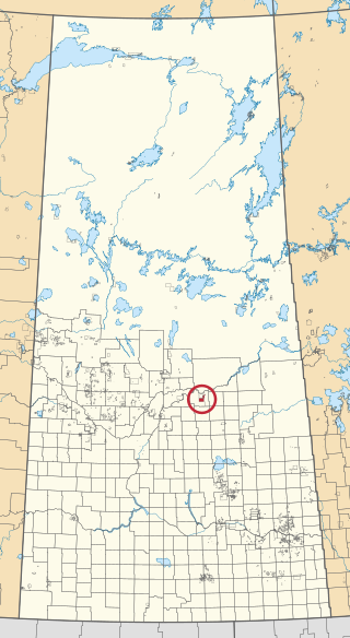
James Smith 100 is an Indian reserve of the James Smith Cree Nation in Saskatchewan. It is about 58 kilometres (36 mi) east of Prince Albert. In the 2016 Canadian Census, it recorded a population of 743 living in 152 of its 152 total private dwellings. In the same year, its Community Well-Being index was calculated at 46 of 100, compared to 58.4 for the average First Nations community and 77.5 for the average non-Indigenous community.

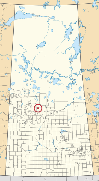
Kinistin 91 is an Indian reserve of the Kinistin Saulteaux Nation in Saskatchewan. It is about 39 kilometres (24 mi) south-east of Melfort. In the 2016 Canadian Census, it recorded a population of 321 living in 82 of its 90 total private dwellings. In the same year, its Community Well-Being index was calculated at 46 of 100, compared to 58.4 for the average First Nations community and 77.5 for the average non-Indigenous community.

Buffalo River Dene Nation 193 is an Indian reserve of the Buffalo River Dene Nation in Saskatchewan. It is 84 kilometres northwest of Île-à-la-Crosse. In the 2016 Canadian Census, it recorded a population of 783 living in 233 of its 260 total private dwellings. In the same year, its Community Well-Being index was calculated at 54 of 100, compared to 58.4 for the average First Nations community and 77.5 for the average non-Indigenous community.

La Plonge 192 is an Indian reserve of the English River First Nation in Saskatchewan. It is about 19 kilometres (12 mi) south of Île-à-la-Crosse. In the 2016 Canadian Census, it recorded a population of 148 living in 46 of its 51 total private dwellings. In the same year, its Community Well-Being index was calculated at 59 of 100, compared to 58.4 for the average First Nations community and 77.5 for the average non-Indigenous community.
Cumberland 100A is an Indian reserve of the James Smith Cree Nation in Saskatchewan. It is 161 kilometres (100 mi) south-east of Prince Albert. The 2016 Canadian Census, recorded a population of 317 living in 79 of its 82 total private dwellings. In the same year, its Community Well-Being index was calculated at 50 of 100, compared to 58.4 for the average First Nations community and 77.5 for the average non-Indigenous community.

Day Star 87 is an Indian reserve of the Day Star First Nation in Saskatchewan. It is 87 kilometres (54 mi) north-west of Fort Qu'Appelle. In the 2016 Canadian Census, it recorded a population of 148 living in 42 of its 62 total private dwellings. In the same year, its Community Well-Being index was calculated at 65 of 100, compared to 58.4 for the average First Nations community and 77.5 for the average non-Indigenous community.

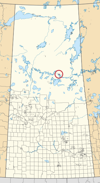
Morin Lake 217 is an Indian reserve of the Lac La Ronge Indian Band in Saskatchewan. It is about 24 kilometres (15 mi) east of Lac la Ronge. In the 2016 Canadian Census, it recorded a population of 577 living in 135 of its 155 total private dwellings. In the same year, its Community Well-Being index was calculated at 45 of 100, compared to 58.4 for the average First Nations community and 77.5 for the average non-Indigenous community.

Muscowpetung 80 is an Indian reserve of the Muscowpetung First Nation in Saskatchewan. It is 31 kilometres (19 mi) west of Fort Qu'Appelle along the south-west shore of Pasqua Lake, which is one of four Fishing Lakes. In the 2016 Canadian Census, it recorded a population of 275 living in 87 of its 112 total private dwellings. In the same year, its Community Well-Being index was calculated at 54 of 100, compared to 58.4 for the average First Nations community and 77.5 for the average non-Indigenous community.

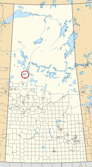
Muskeg Lake 102 is an Indian reserve of the Muskeg Lake Cree Nation in Saskatchewan. It is about 493 kilometres (306 mi) north of Saskatoon. In the 2016 Canadian Census, it recorded a population of 274 living in 104 of its 112 total private dwellings. In the same year, its Community Well-Being index was calculated at 57 of 100, compared to 58.4 for the average First Nations community and 77.5 for the average non-Indigenous community.

Muskowekwan 85 is an Indian reserve of the Muskowekwan First Nation in Saskatchewan. It is about 64 kilometres (40 mi) north-west of Fort Qu'Appelle. In the 2016 Canadian Census, it recorded a population of 436 living in 150 of its 170 total private dwellings. In the same year, its Community Well-Being index was calculated at 52 of 100, compared to 58.4 for the average First Nations community and 77.5 for the average non-Indigenous community.

Pasqua 79 is an Indian reserve of the Pasqua First Nation in Saskatchewan. It is about 16 kilometres (9.9 mi) west of Fort Qu'Appelle. In the 2016 Canadian Census, it recorded a population of 517 living in 173 of its 200 total private dwellings. In the same year, its Community Well-Being index was calculated at 56 of 100, compared to 58.4 for the average First Nations community and 77.5 for the average non-Indigenous community.

Pelican Narrows 184B is an Indian reserve of the Peter Ballantyne Cree Nation in Saskatchewan. It is about 80 kilometres (50 mi) north-east of Flin Flon. In the 2016 Canadian Census, it recorded a population of 1869 living in 327 of its 350 total private dwellings. In the same year, its Community Well-Being index was calculated at 34 of 100, compared to 58.4 for the average First Nations community and 77.5 for the average non-Indigenous community.
Piapot 75 is an Indian reserve of the Piapot Cree Nation in Saskatchewan. It is about 43 kilometres (27 mi) west of Fort Qu'Appelle. In the 2016 Canadian Census, it recorded a population of 516 living in 143 of its 171 total private dwellings. In the same year, its Community Well-Being index was calculated at 55 of 100, compared to 58.4 for the average First Nations community and 77.5 for the average non-Indigenous community.

Poorman 88 is an Indian reserve of the Kawacatoose First Nation in Saskatchewan. It is about 87 kilometres (54 mi) north-west of Fort Qu'Appelle. In the 2016 Canadian Census, it recorded a population of 729 living in 172 of its 196 total private dwellings. In the same year, its Community Well-Being index was calculated at 47 of 100, compared to 58.4 for the average First Nations community and 77.5 for the average non-Indigenous community.

Sturgeon Weir 184F is an Indian reserve of the Peter Ballantyne Cree Nation in Saskatchewan. It is adjacent to Sturgeon Weir 205 and about 55 kilometres (34 mi) south-east of Flin Flon. In the 2016 Canadian Census, it recorded a population of 81 living in 20 of its 26 total private dwellings. In the same year, its Community Well-Being index was calculated at 51 of 100, compared to 58.4 for the average First Nations community and 77.5 for the average non-Indigenous community.

Sucker River 156C is an Indian reserve of the Lac La Ronge Indian Band in Saskatchewan. It is at the mouth of the Nemeiben River on Lac la Ronge, about 230 kilometres (140 mi) north of Prince Albert. In the 2016 Canadian Census, it recorded a population of 416 living in 109 of its 124 total private dwellings. In the same year, its Community Well-Being index was calculated at 49 of 100, compared to 58.4 for the average First Nations community and 77.5 for the average non-Indigenous community.

