
Macklin is a town in Eye Hill Rural Municipality No. 382, Saskatchewan, Canada. The population was 1,247 at the 2021 Canadian census. The town is located on Highway 14 and Highway 31 about 5 km (3 mi) east of the provincial border with Alberta, and is situated near one of the most productive oil and natural gas producing fields in the province.
La Loche is a village in northwest Saskatchewan. It is located at the end of Highway 155 on the eastern shore of Lac La Loche in Canada's boreal forest. La Loche had a population of 2,827 in 2016 and is within the Northern Saskatchewan Administration District.

Fox Valley is a village in the Canadian province of Saskatchewan within the Rural Municipality of Fox Valley No. 171 and Census Division No. 8. Fox Valley is located just off Highway 21, approximately 64 kilometres north of Maple Creek and 51 kilometres south of Leader in the southwest region of the province. The early settlers of the village and surrounding area included many Germans from Russia. The local economy is heavily dependent on agriculture and natural gas.

Division No. 18, Saskatchewan, Canada, is one of the eighteen Statistics Canada census divisions within the province, occupying the northern half of the province. The census division is coextensive with the Northern Saskatchewan Administration District (NSAD).

Consul is a village in the Canadian province of Saskatchewan within the Rural Municipality of Reno No. 51 and Census Division No. 4. The historic Red Coat Trail and Highway 21 pass through the village. The village features one of the last existing grain elevators in the region. It is 211 km southwest of the City of Swift Current.

The Rural Municipality of Senlac No. 411 is a rural municipality (RM) in the Canadian province of Saskatchewan within Census Division No. 13 and SARM Division No. 6. Located in the west-central portion of the province, it is adjacent to the Alberta boundary.
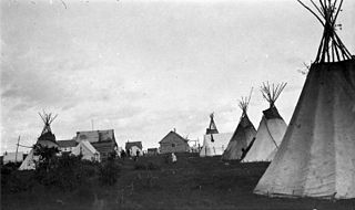
Beauval, Saskatchewan is a northern village located in Northern Saskatchewan, near Lac Île-à-la-Crosse. It was founded in the early 20th century as a Roman Catholic mission and as a transportation centre.
Killaly is a village in the Canadian province of Saskatchewan within the Rural Municipality of McLeod No. 185 and Census Division No. 5. The village is located 23 km south of the City of Melville on Highway 47 at the intersection of Highway 22 and 47, and only 17 minutes north of Crooked Lake.
Flaxcombe is a village in the Canadian province of Saskatchewan within the Rural Municipality of Kindersley No. 290 and Census Division No. 13. The village is located approximately 30 km west of the Town of Kindersley, on Highway 7, and approximately 27 km east of the Alberta-Saskatchewan border.
Goodsoil is a village in the Canadian province of Saskatchewan within the Rural Municipality of Beaver River No. 622 and Census Division No. 17. The Goodsoil Historical Museum Site is a municipal heritage property on the Canadian Register of Historic Places. It is the western gateway to Meadow Lake Provincial Park.
Pierceland is a village in the Canadian province of Saskatchewan within the Rural Municipality of Beaver River No. 622 and Census Division No. 17. It is north of the Beaver River on Saskatchewan Highway 55.
Turnor Lake is a community on the southern shore of Turnor Lake. From Highway 155 it is accessible by Highway 909. The community includes the Northern Hamlet of Turnor Lake and Turnor Lake 193B of the Birch Narrows First Nation.
Weirdale is a village in the Canadian province of Saskatchewan within the Rural Municipality of Garden River No. 490 and Census Division No. 15. Weirdale is about 48 km northeast of the City of Prince Albert along Highway 55.
Smiley is a village in the Canadian province of Saskatchewan within the Rural Municipality of Prairiedale No. 321 and Census Division No. 13. The village is located approximately 20 km northwest of the town of Kindersley at the intersection of Highway 307 and Highway 772. The Grand Trunk Pacific Railway was completed in 1913, bringing an economic boom to the village's early years. On April 26, 1987 the Dodsland subdivision between Dodsland and Smiley was transferred to the Canadian Pacific Railway. Due to the close proximity to major grain centres such as Kindersley, CPR put the line up for abandonment and was granted permission to remove the track by the Canadian Transportation Agency on October 29, 1997.

Pinehouse is a northern village located in the boreal forest of Saskatchewan on the western shore of Pinehouse Lake within the Canadian Shield.
Bear Creek is a northern settlement in northwest Saskatchewan located on Highway 155. This community of 47 people is midway between the towns of Buffalo Narrows to the south and La Loche to the north. It is near the junction of Highway 909 that leads to Turnor Lake to the east. The chairman of this northern settlement is Dean Herman. The northern settlement is an unincorporated community in the Northern Saskatchewan Administration District.
Michel Village is a northern hamlet in Saskatchewan. It is located on the western shore of Peter Pond Lake at the end of Highway 925 north of Dillon. There were 66 residents in Michel Village in 2011. The mayor is Cliff Coombs.
Descharme Lake is a northern settlement on Descharme Lake in the boreal forest of northwest Saskatchewan. A 10 km access road leads west to the community from the Saskatchewan Highway 955 turn-off 87 km north of La Loche. The northern settlement is an unincorporated community in the Northern Saskatchewan Administration District.
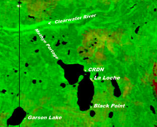
Garson Lake is a northern settlement in Saskatchewan on the eastern shore of Garson Lake. It is located near the Alberta border and can be accessed by Highway 956 off of Highway 155. A winter road connects it to Fort McMurray, Alberta in the winter months.
The Clearwater River Dene Nation is a Dene First Nations band government in the boreal forest area of northern Saskatchewan, Canada. It maintains offices in the village of Clearwater River situated on the eastern shore of Lac La Loche. The Clearwater River Dene Nation reserve of Clearwater River shares its southern border with the village of La Loche.

