
Fond du Lac Dene Nation is a Dene First Nation located in the boreal forest area of northern Saskatchewan, Canada. The main settlement is Fond-du-Lac, situated on the east side of Lake Athabasca. It is a remote fly-in community. The population in 2011 was 874, mainly of Dene and Métis descent. 705 residents selected Dene as their mother tongue in 2011.

Stony Rapids is a northern hamlet in Northern Saskatchewan, Canada. It is located 82 kilometres (51 mi) south of the border to the Northwest Territories, the community is astride the Fond du Lac River. This river connects the community to Fond-du-Lac, Uranium City and Camsell Portage.
The Lac La Ronge Indian Band is a Woodland Cree First Nation in northern Saskatchewan, it is the largest Cree band government in Canada and the largest First Nation in Saskatchewan. The administrative centre of the Lac La Ronge Indian Band is located in La Ronge.

Black Lake is a Denesuline First Nations band government in the boreal forest of northern Saskatchewan, Canada. It is located on the northwest shore of Black Lake where the Fond du Lac River leaves the lake to flow to Lake Athabasca.
Grandmother's Bay 219 is an Indian reserve of the Lac La Ronge Indian Band in Saskatchewan. Located on Otter Lake, part of the Churchill River system, it is 77 kilometers northeast of Lac la Ronge. In the 2016 Canadian Census, it recorded a population of 342 living in 101 of its 115 total private dwellings. In the same year, its Community Well-Being index was calculated at 44 of 100, compared to 58.4 for the average First Nations community and 77.5 for the average non-Indigenous community.

Chicken 224 is an Indian reserve of the Black Lake Denesuline First Nation in Saskatchewan. It is 170 kilometres southeast of Uranium City. In the 2016 Canadian Census, it recorded a population of 1379 living in 263 of its 280 total private dwellings. In the same year, its Community Well-Being index was calculated at 42 of 100, compared to 58.4 for the average First Nations community and 77.5 for the average non-Indigenous community.

Chicken 225 is an Indian reserve of the Black Lake Denesuline First Nation in Saskatchewan. In the 2016 Canadian Census, it recorded a population of 0 living in 0 of its 0 total private dwellings.
Eagles Lake 165C is an Indian reserve of the Canoe Lake Cree First Nation in Saskatchewan. It consists of all that portion of Township 59, Range 14, west of the Third Meridian. In the 2016 Canadian Census, it recorded a population of 92 living in 29 of its 32 total private dwellings. In the same year, its Community Well-Being index was calculated at 72 of 100, compared to 58.4 for the average First Nations community and 77.5 for the average non-Indigenous community.

Fond du Lac 227 is an Indian reserve of the Fond du Lac Denesuline First Nation in Saskatchewan. It is at the east end of Lake Athabasca. In the 2016 Canadian Census, it recorded a population of 903 living in 206 of its 231 total private dwellings. In the same year, its Community Well-Being index was calculated at 52 of 100, compared to 58.4 for the average First Nations community and 77.5 for the average non-Indigenous community.

Fox Point 157D is an Indian reserve of the Lac La Ronge Indian Band in Saskatchewan. It is 16 miles south-east of La Ronge, and on the south-west shore of Lac la Ronge.

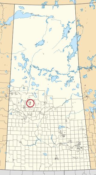
Makwa Lake 129B is an Indian reserve of the Makwa Sahgaiehcan First Nation in Saskatchewan. It is 95 miles northwest of North Battleford. In the 2016 Canadian Census, it recorded a population of 982 living in 226 of its 444 total private dwellings. In the same year, its Community Well-Being index was calculated at 47 of 100, compared to 58.4 for the average First Nations community and 77.5 for the average non-Indigenous community.

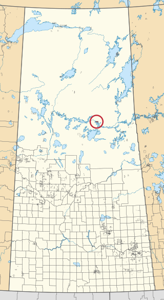
Meadow Lake 105C is an Indian reserve of the Flying Dust First Nation in Saskatchewan. It is Lots 12, 13, and 14, Block 14, northeast quarter of Section 26, Township 59, Range 17, west of the Third Meridian.

Muscowpetung 80 is an Indian reserve of the Muscowpetung First Nation in Saskatchewan. It is 31 kilometres west of Fort Qu'Appelle along the south-west shore of Pasqua Lake, which is one of four Fishing Lakes. In the 2016 Canadian Census, it recorded a population of 275 living in 87 of its 112 total private dwellings. In the same year, its Community Well-Being index was calculated at 54 of 100, compared to 58.4 for the average First Nations community and 77.5 for the average non-Indigenous community.

Muskeg Lake 102 is an Indian reserve of the Muskeg Lake Cree Nation in Saskatchewan. It is 93 kilometres north of Saskatoon. In the 2016 Canadian Census, it recorded a population of 274 living in 104 of its 112 total private dwellings. In the same year, its Community Well-Being index was calculated at 57 of 100, compared to 58.4 for the average First Nations community and 77.5 for the average non-Indigenous community.

Pasqua 79 is an Indian reserve of the Pasqua First Nation in Saskatchewan. It is 16 kilometres west of Fort Qu'Appelle. In the 2016 Canadian Census, it recorded a population of 517 living in 173 of its 200 total private dwellings. In the same year, its Community Well-Being index was calculated at 56 of 100, compared to 58.4 for the average First Nations community and 77.5 for the average non-Indigenous community.

Piapot 75H is an Indian reserve of the Piapot Cree Nation in Saskatchewan. It is fourteen quarter sections located in Townships 9, 10, and 12 in Ranges 21 and 22 west of the Second Meridian, in the vicinity of Dummer, Saskatchewan. In the 2016 Canadian Census, it recorded a population of 0 living in 0 of its 0 total private dwellings.

Standing Buffalo 78 is an Indian reserve of the Standing Buffalo Dakota Nation in Saskatchewan. It is 8 kilometres north-west of Fort Qu'Appelle. In the 2016 Canadian Census, it recorded a population of 569 living in 184 of its 198 total private dwellings. In the same year, its Community Well-Being index was calculated at 59 of 100, compared to 58.4 for the average First Nations community and 77.5 for the average non-Indigenous community.
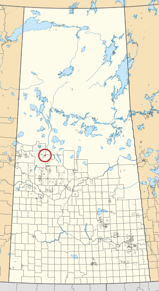
Witchekan Lake 117 is an Indian reserve of the Witchekan Lake First Nation in Saskatchewan. It is 90 kilometres northeast of North Battleford. In the 2016 Canadian Census, it recorded a population of 10 living in 3 of its 3 total private dwellings.

Bow River is a river in the Northern Administration District of the Canadian province of Saskatchewan. The river begins at Ridge Lake of Bow River chain lakes in Clarence-Steepbank Lakes Provincial Park and flows in a northerly direction into Lac la Ronge and Lac La Ronge Provincial Park. Rapid River connects Lac la Ronge to the Churchill River. There are no communities nor settlements along the river's course.

