The Lac La Ronge Indian Band is a Woodland Cree First Nation in northern Saskatchewan, it is the largest Cree band government in Canada and the largest First Nation in Saskatchewan. The administrative centre of the Lac La Ronge Indian Band is located in La Ronge.
Grandmother's Bay 219 is an Indian reserve of the Lac La Ronge Indian Band in Saskatchewan. Located on Otter Lake, part of the Churchill River system, it is 77 kilometers northeast of Lac la Ronge. In the 2016 Canadian Census, it recorded a population of 342 living in 101 of its 115 total private dwellings. In the same year, its Community Well-Being index was calculated at 44 of 100, compared to 58.4 for the average First Nations community and 77.5 for the average non-Indigenous community.

Buffalo River Dene Nation 193 is an Indian reserve of the Buffalo River Dene Nation in Saskatchewan. It is 84 kilometres northwest of Île-à-la-Crosse. In the 2016 Canadian Census, it recorded a population of 783 living in 233 of its 260 total private dwellings. In the same year, its Community Well-Being index was calculated at 54 of 100, compared to 58.4 for the average First Nations community and 77.5 for the average non-Indigenous community.

La Plonge 192 is an Indian reserve of the English River First Nation in Saskatchewan. It is 19 kilometres south of Île-à-la-Crosse. In the 2016 Canadian Census, it recorded a population of 148 living in 46 of its 51 total private dwellings. In the same year, its Community Well-Being index was calculated at 59 of 100, compared to 58.4 for the average First Nations community and 77.5 for the average non-Indigenous community.

Chicken 224 is an Indian reserve of the Black Lake Denesuline First Nation in Saskatchewan. It is 170 kilometres southeast of Uranium City. In the 2016 Canadian Census, it recorded a population of 1379 living in 263 of its 280 total private dwellings. In the same year, its Community Well-Being index was calculated at 42 of 100, compared to 58.4 for the average First Nations community and 77.5 for the average non-Indigenous community.

Flying Dust 105 is an Indian reserve of the Flying Dust First Nation in Saskatchewan. It is less than a kilometre northwest of Meadow Lake. In the 2016 Canadian Census, it recorded a population of 577 living in 169 of its 187 total private dwellings. In the same year, its Community Well-Being index was calculated at 63 of 100, compared to 58.4 for the average First Nations community and 77.5 for the average non-Indigenous community.

Fond du Lac 227 is an Indian reserve of the Fond du Lac Denesuline First Nation in Saskatchewan. It is at the east end of Lake Athabasca. In the 2016 Canadian Census, it recorded a population of 903 living in 206 of its 231 total private dwellings. In the same year, its Community Well-Being index was calculated at 52 of 100, compared to 58.4 for the average First Nations community and 77.5 for the average non-Indigenous community.

Four Portages 157C is an Indian reserve of the Lac La Ronge Indian Band in Saskatchewan. It is 23 miles (37 km) north-east of La Ronge, and on the north shore of Lac la Ronge.

Lac la Hache 220 is an Indian reserve of the Hatchet Lake Dene Nation in Saskatchewan. It is 354 kilometres north of Flin Flon. In the 2016 Canadian Census, it recorded a population of 1377 living in 260 of its 282 total private dwellings. In the same year, its Community Well-Being index was calculated at 37 of 100, compared to 58.4 for the average First Nations community and 77.5 for the average non-Indigenous community.

Little Hills 158 is an Indian reserve of the Lac La Ronge Indian Band in Saskatchewan. In the 2016 Canadian Census, it recorded a population of 0 living in 0 of its 0 total private dwellings.

Little Hills 158A is an Indian reserve of the Lac La Ronge Indian Band in Saskatchewan. It is 6 miles south-west of La Ronge, and on the north bank of the Little Hills River.

Little Hills 158B is an Indian reserve of the Lac La Ronge Indian Band in Saskatchewan. It is 8 miles southwest of La Ronge, and on the south-east shore of Bigstone Lake.

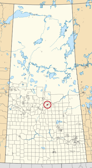
Little Red River 106C is an Indian reserve of the Lac La Ronge Indian Band in Saskatchewan. It is 34 kilometres north of Prince Albert. In the 2016 Canadian Census, it recorded a population of 354 living in 88 of its 98 total private dwellings. In the same year, its Community Well-Being index was calculated at 48 of 100, compared to 58.4 for the average First Nations community and 77.5 for the average non-Indigenous community.

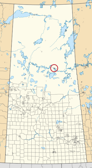
Morin Lake 217 is an Indian reserve of the Lac La Ronge Indian Band in Saskatchewan. It is 24 kilometres east of Lac la Ronge. In the 2016 Canadian Census, it recorded a population of 577 living in 135 of its 155 total private dwellings. In the same year, its Community Well-Being index was calculated at 45 of 100, compared to 58.4 for the average First Nations community and 77.5 for the average non-Indigenous community.
The Muskoday Reserve is an Indian reserve of the Muskoday First Nation in Saskatchewan. It is 19 kilometres southeast of Prince Albert. In the 2016 Canadian Census, it recorded a population of 647 living in 205 of its 217 total private dwellings. In the same year, its Community Well-Being index was calculated at 64 of 100, compared to 58.4 for the average First Nations community and 77.5 for the average non-Indigenous community.

Ocean Man 69 is an Indian reserve of the Ocean Man First Nation in Saskatchewan. It is 20 kilometres northeast of Stoughton. In the 2016 Canadian Census, it recorded a population of 185 living in 56 of its 61 total private dwellings. In the same year, its Community Well-Being index was calculated at 48 of 100, compared to 58.4 for the average First Nations community and 77.5 for the average non-Indigenous community.

Potato River 156A is an Indian reserve of the Lac La Ronge Indian Band in Saskatchewan. It is 6 miles south of La Ronge.

Stanley 157 is an Indian reserve of the Lac La Ronge Indian Band in Saskatchewan. It is 56 kilometres northeast of Lac la Ronge. In the 2016 Canadian Census, it recorded a population of 1840 living in 451 of its 466 total private dwellings. In the same year, its Community Well-Being index was calculated at 52 of 100, compared to 58.4 for the average First Nations community and 77.5 for the average non-Indigenous community.

Sucker River 156C is an Indian reserve of the Lac La Ronge Indian Band in Saskatchewan. It is 230 kilometres north of Prince Albert. In the 2016 Canadian Census, it recorded a population of 416 living in 109 of its 124 total private dwellings. In the same year, its Community Well-Being index was calculated at 49 of 100, compared to 58.4 for the average First Nations community and 77.5 for the average non-Indigenous community.

Wahpaton 94A is an Indian reserve of the Wahpeton Dakota Nation in Saskatchewan. It is 10 kilometres north of Prince Albert. In the 2016 Canadian Census, it recorded a population of 309 living in 70 of its 80 total private dwellings. In the same year, its Community Well-Being index was calculated at 58 of 100, compared to 58.4 for the average First Nations community and 77.5 for the average non-Indigenous community.

