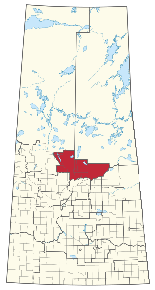
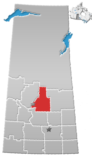
Saskatchewan Rivers is a provincial electoral district for the Legislative Assembly of Saskatchewan, Canada. This constituency is located where the North Saskatchewan River and the South Saskatchewan River merge.
Division No. 15 is one of eighteen census divisions in the province of Saskatchewan, Canada, as defined by Statistics Canada. It is located in the north-central part of the province. The most populous community in this division is Prince Albert.

Division No. 17 is one of eighteen census divisions in the province of Saskatchewan, Canada, as defined by Statistics Canada. It is located in the west-northwest part of the province, bordering Alberta. The most populous community in this division is the interprovincial city of Lloydminster. Another important population centre is the town of Meadow Lake.
Highway 953 is a provincial highway in the Canadian province of Saskatchewan. It runs from Highway 952 to Highway 2. It is about 32 kilometres (20 mi) long.
Big River is a town located on the southern end of Cowan Lake in north central Saskatchewan, Canada. It is just north of Saskatchewan's extensive grain belt on Highway 55 and about 16 kilometres (10 mi) west of Prince Albert National Park. Delaronde Lake is accessed east of the town. Big River is approximately 132 kilometres (82 mi) from Prince Albert.
The Lac La Ronge Indian Band is a Woodland Cree First Nation in northern Saskatchewan, it is the largest Cree band government in Canada and the largest First Nation in Saskatchewan. The administrative centre of the Lac La Ronge Indian Band is located in La Ronge.
Meath Park is a village in the Canadian province of Saskatchewan within the Rural Municipality of Garden River No. 490 and Census Division No. 15.
Middle Lake is a village in the Canadian province of Saskatchewan within the Rural Municipality of Three Lakes No. 400 and Census Division No. 15. The village has a public K-12 school, a nursing home, and a regional park. It is adjacent to Lucien Lake and accessed from Highway 20. The surrounding area is largely agricultural.

Sheho is a village in the Canadian province of Saskatchewan within the Rural Municipality of Insinger No. 275 and Census Division No. 9. Sheho is located on Saskatchewan Highway 16, in southeast Saskatchewan between Foam Lake to the west and the City of Yorkton to the east. Sheho Lake post office first opened in 1891 at the legal land description of Sec.28, Twp.30, R.9, W2 before moving slightly and changing name to Sheho.

Black Lake is a Denesuline First Nations band government in the boreal forest of northern Saskatchewan, Canada. It is located on the northwest shore of Black Lake where the Fond du Lac River leaves the lake to flow to Lake Athabasca.
Prince Albert City was a provincial electoral district for the Legislative Assembly of the province of Saskatchewan, Canada. This constituency was one of 25 created for the 1st Saskatchewan general election in 1905.
Codette is a village in the Canadian province of Saskatchewan within the Rural Municipality of Nipawin No. 487 and Census Division No. 14. The village is located 10 km south of Nipawin at the junction of Highway 35 and Highway 789.
Guise Beach is a hamlet in the Canadian province of Saskatchewan. It is located on the western shore of Emma Lake.
McIntosh Point is a hamlet in the Canadian province of Saskatchewan. It is located at McIntosh Point on the western shore of Emma Lake.
Murray Point is a hamlet in the Canadian province of Saskatchewan. The community is located on the western shore of Emma Lake and surrounded by Great Blue Heron Provincial Park.
Neis Beach is a hamlet in the Canadian province of Saskatchewan. It is located at the south-east corner of Emma Lake.
Okema Beach is a hamlet in the Canadian province of Saskatchewan. It is located on the shore of Emma Lake adjacent to Great Blue Heron Provincial Park.
Emma Lake is an unincorporated place in the Canadian province of Saskatchewan.
Great Blue Heron Provincial Park is a recreational park in the central region of the Canadian province of Saskatchewan in the boreal forest ecozone of Canada. It is adjacent to the eastern boundary of Prince Albert National Park, about 50 kilometres (31 mi) north of the city of Prince Albert. The provincial park was established in 2013 from two pre-existing provincial recreation sites – Emma Lake and Anglin Lake Recreation Sites – and the addition of a large tract of Crown land.

Spruce River, also called Little Red River, is a river in the north-central region of the Canadian province of Saskatchewan. It begins in the Waskesiu Hills in Prince Albert National Park and flows generally in a southward direction through boreal forests, glacier carved hills and valleys, muskeg, and prairie en route to the North Saskatchewan River at the east end of the city of Prince Albert.
