
Saskatchewan is a province in Western Canada, bordered on the west by Alberta, on the north by the Northwest Territories, on the east by Manitoba, to the northeast by Nunavut, and to the south by the United States. Saskatchewan and Alberta are the only landlocked provinces of Canada. In 2024, Saskatchewan's population was estimated at 1,231,043. Nearly 10% of Saskatchewan's total area of 651,900 km2 (251,700 sq mi) is fresh water, mostly rivers, reservoirs, and lakes.

Regina is the capital city of the Canadian province of Saskatchewan. The city is the second-largest in the province, after Saskatoon, and is a commercial centre for southern Saskatchewan. As of the 2021 census, Regina had a city population of 226,404, and a metropolitan area population of 249,217. It is governed by Regina City Council. The city is surrounded by the Rural Municipality of Sherwood No. 159.

White City is a town in southeast Saskatchewan. Situated at the intersection of Highway 48 and the Trans-Canada Highway, the town is part of the White Butte region and neighbours Balgonie, Pilot Butte, and the province's capital city, Regina. White City is primarily populated by people who commute to work in Regina. Its motto is "Your Way of Life".

Regina Northeast is a provincial electoral district for the Legislative Assembly of Saskatchewan, Canada. This district includes the neighbourhoods of Parkridge, Uplands, Glencairn and Glencairn Village.

Regina Douglas Park is a provincial electoral district for the Legislative Assembly of Saskatchewan, Canada. Created for the 18th Saskatchewan general election as "Regina Victoria", it was redrawn and renamed "Regina Douglas Park" by the Representation Act, 2002 (Saskatchewan).

The Rural Municipality of Lumsden No. 189 is a rural municipality (RM) in the Canadian province of Saskatchewan within Census Division No. 6 and SARM Division No. 2. It is located in the south-east portion of the province.
Patuanak is a community in northern Saskatchewan, Canada. It is the administrative headquarters of the Dene First Nations reserve near Churchill River and the north end of Lac Île-à-la-Crosse. In Dene, it sounds similar to Boni Cheri (Bëghą́nı̨ch’ërë).
Highway 11 is a major north-south highway in Saskatchewan, Canada that connects the province's three largest cities: Regina, Saskatoon, and Prince Albert. It is a structural pavement major arterial highway which is approximately 391 kilometres (243 mi) long. It is also known as the Louis Riel Trail (LRT) after the 19th century Métis leader. It runs from Highway 1 in Regina until Highway 2 south of Prince Albert. Historically the southern portion between Regina and Saskatoon was Provincial Highway 11, and followed the Dominion Survey lines on the square, and the northern portion between Saskatoon and Prince Albert was Provincial Highway 12.
Highway 6 is a paved undivided major provincial highway in the Canadian province of Saskatchewan. It runs from Montana Highway 16 at the Canada–US border near the Canada customs port of Regway to Highway 55 near Choiceland. Highway 6 is about 523 km (325 mi) long. The CanAm Highway comprises Saskatchewan Highways from south to north: SK 35, Sk 39, Sk 6, Sk 3, as well as Sk 2. 330 kilometres (210 mi) of Saskatchewan Highway 6 contribute to the CanAm Highway between Corinne and Melfort.

The Rural Municipality of North Qu'Appelle No. 187 is a rural municipality (RM) in the Canadian province of Saskatchewan within Census Division No. 6 and SARM Division No. 1. It is located in the south-east portion of the province.

Seven neighbourhoods are of considerable note:

The Rural Municipality of Edenwold No. 158 is a rural municipality (RM) in the Canadian province of Saskatchewan within Census Division No. 6 and SARM Division No. 2. It is located in the southeast portion of the province, east of the City of Regina.

Pinehouse is a northern village located in the boreal forest of Saskatchewan on the western shore of Pinehouse Lake within the Canadian Shield.
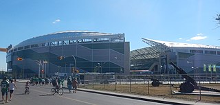
Mosaic Stadium is an open-air stadium at REAL District in Regina, Saskatchewan. Announced on July 12, 2012, the stadium replaced Mosaic Stadium at Taylor Field as the home field of the Canadian Football League's Saskatchewan Roughriders. It was designed by HKS, Inc., in joint venture with B+H, the architects of record. Preliminary construction on the new stadium began in early 2014, and it was declared "substantially complete" on August 31, 2016. The stadium is owned by the city of Regina and operated by the Regina Exhibition Association Ltd. (REAL).

Carla Beck is a Canadian politician who has served as leader of the Saskatchewan New Democratic Party since 2022. She was elected to the Legislative Assembly of Saskatchewan in the 2016 provincial election. She represents the electoral district of Regina Lakeview.
Deer Valley is an organized hamlet in the Rural Municipality of Lumsden No. 189, Saskatchewan, Canada. It is approximately 25 km (16 mi) northwest of Regina and 6 km (3.7 mi) south of the Town of Lumsden.

Alvin Horace "Al" Ritchie, also known by his nickname "the Silver Fox", was a Canadian football player, coach, and administrator who was the head coach of the Regina Roughriders from 1928 to 1932, in 1935, and in 1942. He had many accomplishments and honors, including being named to the Canadian Football Hall of Fame, Canada's Sports Hall of Fame and the Saskatchewan Sports Hall of Fame. The Al Ritchie Memorial Stadium, Al Ritchie Arena, and Al Ritchie Neighborhood are named in his honor.
