
The Rural Municipality of Sarnia No. 221 is a rural municipality (RM) in the Canadian province of Saskatchewan within Census Division No. 6 and SARM Division No. 2. It is located in the south-central portion of the province.
The Rural Municipality of Leask No. 464 is a rural municipality (RM) in the Canadian province of Saskatchewan within Census Division No. 16 and SARM Division No. 5. It is located west of the city of Prince Albert.

The Rural Municipality of Invergordon No. 430 is a rural municipality (RM) in the Canadian province of Saskatchewan within Census Division No. 15 and SARM Division No. 5. It is located west of the city of Melfort.

The Rural Municipality of Stonehenge No. 73 is a rural municipality (RM) in the Canadian province of Saskatchewan within Census Division No. 3 and SARM Division No. 2. It is located in the south-central portion of the province.

The Rural Municipality of Foam Lake No. 276 is a rural municipality (RM) in the Canadian province of Saskatchewan within Census Division No. 10 and SARM Division No. 4. It is located in the east-central portion of the province.

The Rural Municipality of Victory No. 226 is a rural municipality (RM) in the Canadian province of Saskatchewan within Census Division No. 7 and SARM Division No. 3.

The Rural Municipality of Terrell No. 101 is a rural municipality (RM) in the Canadian province of Saskatchewan within Census Division No. 3 and SARM Division No. 2. It is located in the southwest portion of the province.
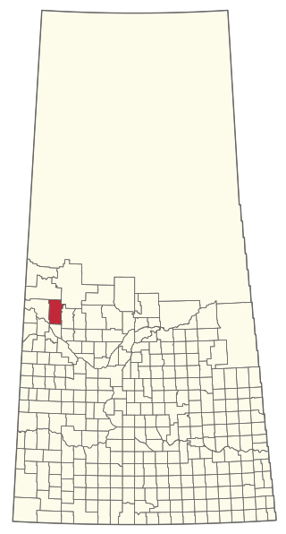
Indian Point – Golden Sands is a former organized hamlet of the Rural Municipality of Parkdale No. 498 that is now part of the Resort Village of Turtle View in Saskatchewan, Canada. It is also recognized as a designated place by Statistics Canada. It is located on the east shore of Turtle Lake, approximately 209 kilometres (130 mi) northwest of Saskatoon.

The Rural Municipality of Lake Alma No. 8 is a rural municipality (RM) in the Canadian province of Saskatchewan within Census Division No. 2 and SARM Division No. 2. Located in the southeast portion of the province, it is adjacent to the United States border, neighbouring Sheridan County in Montana and Divide County in North Dakota.

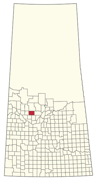
Sunset View Beach is an organized hamlet in the Canadian province of Saskatchewan within the RM of Mervin No. 499 and Census Division No. 17. Part of the RM of Parkdale No. 498 prior to September 1992, it subsequently held resort village status until it dissolved to become part of the RM of Mervin No. 499 in January 2015. Sunset View Beach is on the southeast shore of Turtle Lake, approximately 43 kilometres (27 mi) northeast of the town of Turtleford and 102 kilometres (63 mi) north of the city of North Battleford.

The Rural Municipality of Moose Mountain No. 63 is a rural municipality (RM) in the Canadian province of Saskatchewan within Census Division No. 1 and SARM Division No. 1. It is located in the south-east portion of the province.
The Rural Municipality of Excel No. 71 is a rural municipality (RM) in the Canadian province of Saskatchewan within Census Division No. 3 and SARM Division No. 2. It is located in the south-central portion of the province.

The Rural Municipality of Coteau No. 255 is a rural municipality (RM) in the Canadian province of Saskatchewan within Census Division No. 7 and SARM Division No. 3.
The Rural Municipality of Keys No. 303 is a rural municipality (RM) in the Canadian province of Saskatchewan within Census Division No. 9 and SARM Division No. 4.
The Rural Municipality of Sasman No. 336 is a rural municipality (RM) in the Canadian province of Saskatchewan within Census Division No. 10 and SARM Division No. 4.

The Rural Municipality of Loon Lake No. 561 is a rural municipality (RM) in the Canadian province of Saskatchewan within Census Division No. 17 and SARM Division No. 6.
The Rural Municipality of Meeting Lake No. 466 is a rural municipality (RM) in the Canadian province of Saskatchewan within Census Division No. 16 and SARM Division No. 6.
The Rural Municipality of Mervin No. 499 is a rural municipality (RM) in the Canadian province of Saskatchewan within Census Division No. 17 and SARM Division No. 6.

The Rural Municipality of Paddockwood No. 520 is a rural municipality (RM) in the Canadian province of Saskatchewan within Census Division No. 15 and SARM Division No. 5.

The Rural Municipality of Parkdale No. 498 is a rural municipality (RM) in the Canadian province of Saskatchewan within Census Division No. 17 and SARM Division No. 6.


