
Kandahar is a hamlet in Rural Municipality of Big Quill No. 308, Saskatchewan, Canada. Listed as a designated place by Statistics Canada, the hamlet had a population of 20 in the Canada 2016 Census. Located on Highway 16 near Wynyard, Saskatchewan, the community was named by Canadian Pacific Railway executives in the late 19th century for a British military victory in Kandahar, Afghanistan. The hamlet is too small to be enumerated on its own, so its population belongs to the Rural Municipality of Big Quill No. 308. It is located near the south shore of Big Quill Lake, the largest inland body of salt water in Canada.
Amsterdam is a hamlet within the Rural Municipality of Buchanan No. 304, Saskatchewan, Canada. Listed as a designated place by Statistics Canada, the hamlet had a population of 25 in the Canada 2016 Census. The hamlet is located 63.9 km north of the city of Yorkton and 1.5 km west of Highway 9. The community was founded at the turn of the 20th century by Dutch immigrants, hence the name. In its prime, the community had a post office, grain elevator, garage, and a school. It, like many small towns, has been hit hard by the gradual trend toward urbanization. The hamlet now has fewer than 25 people; most are of Ukrainian descent.
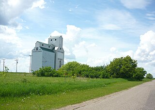
Ebenezer is a village in the Canadian province of Saskatchewan within the Rural Municipality of Orkney No. 244 and Census Division No. 9. The village is located 18 km north of the City of Yorkton, on Highway 9.
Piapot is a hamlet within the Rural Municipality of Piapot No. 110, Saskatchewan, Canada. Listed as a designated place by Statistics Canada, the hamlet had a population of 50 in the Canada 2016 Census.

Meyronne is a special service area in the Canadian province of Saskatchewan.
Handel is a special service area in Grandview No. 349, Saskatchewan, Canada. The population was 25 at the time of the 2006 Census. The community is located approximately 45 km directly west of the town of Biggar on Highway 51.
Mantario is a special service area in the Rural Municipality of Chesterfield No. 261 in the Canadian province of Saskatchewan.It held village status prior to June 30, 2007. The population was 5 people in 2011. The community is located 70 km southwest of the Town of Kindersley on Highway 44.
Minton is a village in the Canadian province of Saskatchewan within the Rural Municipality of Surprise Valley No. 9 and Census Division No. 2. It is on Highway 6 just north of its intersection with Highway 18, 19 km north of the Raymond-Regway Border Crossing on the Montana-Saskatchewan border. The village was named after Minton, Shropshire in England. The name was given by the Canadian Pacific Railway.

Simmie is a hamlet in Bone Creek Rural Municipality No. 108, Saskatchewan, Canada. Listed as a designated place by Statistics Canada, the hamlet had a population of 41 in the Canada 2016 Census. The hamlet is located on Highway 343 and Highway 631, about 50 km southwest of Swift Current.

Penzance is a special service area in the Rural Municipality of Sarnia No. 221, in the Canadian province of Saskatchewan. It held village status prior to January 31, 2008. The community is located 88 km north of the City of Moose Jaw on Highway 2. Penzance was named after the original Penzance, in Cornwall, England.
Beaver Creek is a hamlet in the Rural Municipality of Dundurn No. 314, Saskatchewan, Canada. Listed as a designated place by Statistics Canada, the hamlet had a population of 107 in the Canada 2016 Census.
Chortitz is a hamlet in Coulee Rural Municipality No. 136, Saskatchewan, Canada. Listed as a designated place by Statistics Canada, the hamlet had a population of 26 in the Canada 2006 Census. The hamlet is located on Highway 379, about 25 km south of Swift Current.

Fiske is a hamlet in Pleasant Valley Rural Municipality No. 288, Saskatchewan, Canada. Listed as a designated place by Statistics Canada, the hamlet had a population of 65 in the Canada 2016 Census. Fiske is located approximately 53.7 kilometres (33.4 mi) east of Kindersley and 30.6 kilometres (19.0 mi) west of Rosetown on Highway 7.
Delmas is a hamlet in Battle River Rural Municipality No. 438, Saskatchewan, Canada. Listed as a designated place by Statistics Canada, the hamlet had a population of 128 in the Canada 2016 Census. The hamlet is located approximately 32.6 kilometres (20.3 mi) west of North Battleford on Highway 16.
Hendon is a hamlet in the Rural Municipality of Lakeview No. 337, Saskatchewan, Canada. Listed as a designated place by Statistics Canada, the hamlet had a population of 20 in the Canada 2016 Census.
Kuroki is a hamlet in the Rural Municipality of Sasman No. 336, Saskatchewan, Canada. Listed as a designated place by Statistics Canada, the hamlet had a population of 50 in the Canada 2016 Census. The community is named after the Japanese general Kuroki Tamemoto.
North Shore Fishing Lake is a hamlet in the Rural Municipality of Sasman No. 336, Saskatchewan, Canada. Listed as a designated place by Statistics Canada, the hamlet had a population of 50 in the Canada 2016 Census. It is located on the north-eastern shore of Fishing Lake.
Ottman-Murray Beach is a hamlet in the Canadian province of Saskatchewan. Listed as a designated place by Statistics Canada, the hamlet had a population of 15 in the Canada 2016 Census. It is located on the eastern shore of Fishing Lake.

Wymark is a hamlet in Swift Current Rural Municipality No. 137, Saskatchewan, Canada. Listed as a designated place by Statistics Canada, the hamlet had a population of 144 in the Canada 2006 Census. The hamlet is located on Highway 628 about 2 km north of Highway 363, and 15 km south of Swift Current.
Shackleton is a special service area in the Rural Municipality of Miry Creek No. 229, Saskatchewan, Canada. It previously held the status of village until December 31, 2013. The community is located 81 km (50 mi) northwest of the City of Swift Current on Highway 32.

