
Moose Range
Location of Moose Range in Saskatchewan
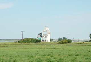
Moose Range is a hamlet in the Canadian province of Saskatchewan.
Moose Range is a hamlet in the Canadian province of Saskatchewan.

Bonnycastle is a neighborhood four miles (6 km) southeast of downtown Louisville, Kentucky USA. It is considered a part of a larger area of Louisville called The Highlands. Its boundaries are Bardstown Road, Cherokee Road, Eastern Parkway and Speed Avenue.

Carrot River is a town located in east-central Saskatchewan in Canada. The administration office for the Rural Municipality of Moose Range No. 486 is located in Carrot River.

Division No. 14 is one of eighteen census divisions in the province of Saskatchewan, Canada, as defined by Statistics Canada. It is located on the northern portion of Southeast Saskatchewan, bordering Manitoba. The most populous community in this division is the city of Melfort. Other important communities are the towns of Nipawin and Tisdale.
Parkbeg is a hamlet in Wheatlands Rural Municipality No. 163, Saskatchewan, Canada. The hamlet is located at the junction of Highway 1 and Highway 627 approximately 58 km directly west of the City of Moose Jaw on the Trans Canada Highway.
The Nisbet Provincial Forest is a provincially protected mixed-wood forest surrounded by Aspen parkland in North Central Saskatchewan, Canada. It consists of a north block north of the city of Prince Albert, Saskatchewan, and a south block between Duck Lake, Saskatchewan, MacDowall, Saskatchewan and Lily Plain, Saskatchewan. The forest drew Métis and white settlers to the area during the 1860s to 1880s and was an important source of building materials and fuel in this period. Today it is a provincially protected area although cattle grazing and recreational use including cross country skiing, snowmobiling, hiking, and hunting in the area are permitted.
St. Boswells is a hamlet in Glen Bain Rural Municipality No. 105, Saskatchewan, Canada. The hamlet is about 8 km east of Highway 19, and about 25 km northwest of the town of Gravelbourg. Very little remains of the former village except a well known as the best water around, and sidewalks which mark the once prosperous business section of St. Boswells.
Ardill is a hamlet in RM of Lake Johnston No. 102, Saskatchewan, Canada. Listed as a designated place by Statistics Canada, the hamlet had a listed population of 0 in the Canada 2006 Census.
Evergreen Beach, also known as Evergreen Brightsand, is an organized hamlet in the Canadian province province of Saskatchewan under the jurisdiction of the Rural Municipality of Mervin No. 499.
Kuroki is a hamlet in the Rural Municipality of Sasman No. 336, Saskatchewan, Canada. Listed as a designated place by Statistics Canada, the hamlet had a population of 50 in the Canada 2016 Census. The community is named after the Japanese general Kuroki Tamemoto.

Oungre is a hamlet in the Canadian province of Saskatchewan. It is in the RM of Souris Valley No. 7.
Taylor Beach is a hamlet in the Canadian province of Saskatchewan.
Wishart is a hamlet in Emerald Rural Municipality No. 277 in the Canadian province of Saskatchewan. It is listed as a designated place by Statistics Canada. The hamlet had a population of 95 in the Canada 2006 Census. It previously held the status of village until January 1, 2002. The hamlet is located 32 km southwest of the village of Elfros at the intersection of highway 639 and highway 743.

Tobin Lake is a reservoir along the course of the Saskatchewan River in the Canadian province of Saskatchewan. Tobin Lake was formed by the building of the E.B. Campbell Dam on the Saskatchewan River in 1963. Tobin Lake is named for William Thorburn, who was a fur trader on the Saskatchewan River. He had built a trading post on the Saskatchewan River where it is met by the Petaigan River. The rapids near the post became known as the "Thornburn Rapids". The name was later shortened to "Tobin Rapids".

Jedburgh is a hamlet in Garry No. 245, Saskatchewan, Canada and is the seat of the rural municipality of Garry. The hamlet is located at the junction of Range road 80 and Township road 270 approximately 20 km (12 mi) northwest of the City of Yorkton.
Spring Valley is a hamlet in Terrell Rural Municipality No. 101 in the province of Saskatchewan, Canada. Located at the end of highway 715, and approximately 62 km south of the city of Moose Jaw.
Stalwart is a hamlet in Saskatchewan.
Wolseley was a provincial electoral district for the Legislative Assembly of the province of Saskatchewan, Canada. Centred on the town of Wolseley, it was one of 25 constituencies created for the 1st Saskatchewan general election in 1905.

The Rural Municipality of Moose Mountain No. 63 is a rural municipality (RM) in the Canadian province of Saskatchewan within Census Division No. 1 and SARM Division No. 1. It is located in the south-east portion of the province.

The Rural Municipality of Moose Range No. 486 is a rural municipality (RM) in the Canadian province of Saskatchewan within Census Division No. 14 and SARM Division No. 4.
Summerberry is an organized hamlet in the Rural Municipality of Wolseley No. 155, Saskatchewan, Canada that previously held village status until December 31, 1972. It is located between the towns of Wolseley and Grenfell on Highway 1, 15 km east of Wolseley.
53°14′00″N103°42′02″W / 53.23333°N 103.70056°W
| | This Saskatchewan location article is a stub. You can help Wikipedia by expanding it. |