| Redberry Lake | |
|---|---|
 Redberry Lake | |
 Redberry Lake Location in Saskatchewan  Redberry Lake Redberry Lake (Canada) | |
| Location | RM of Redberry No. 435, Saskatchewan |
| Coordinates | 52°42′N107°10′W / 52.700°N 107.167°W |
| Type | Salt lake |
| Primary inflows | Marshy Creek, natural springs |
| Primary outflows | None |
| Basin countries | Canada |
| Max. length | 9.7 km (6.0 mi) |
| Max. width | 9.7 km (6.0 mi) |
| Surface area | 5,169 ha (12,770 acres) |
| Average depth | +/- 11 m (36 ft) |
| Max. depth | 18 m (59 ft) |
| Shore length1 | 53 km (33 mi) |
| Surface elevation | 507 m (1,663 ft) |
| Islands |
|
| Settlements | None |
| 1 Shore length is not a well-defined measure. | |
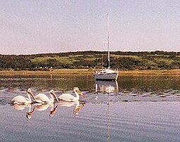
Redberry Lake [1] is a kettle salt lake near Hafford in the Canadian province of Saskatchewan. Named after the buffaloberry, it is a medium-sized saline lake within an area characterized by mostly fresh water aquatic environments. The lake makes up the core protected area of the Redberry Lake (UNESCO) Biosphere Reserve and is a federal bird sanctuary of the same name. It is also an Important Bird Area (IBA) of Canada and its northern most island is the location of the provincial Redberry Wildlife Refuge ( 52°42′00″N107°12′02″W / 52.7001°N 107.2006°W ). [2] A small regional park is situated at the north-west corner of the lake. The countryside surrounding Redberry Lake is typical of the aspen parkland biome of which it is a part. [3] [4] [5]
Contents
Over the past several decades, Redberry Lake water levels have been declining and the salt concentrations increasing. With the declining levels, the shoreline length has been decreasing and the size of the islands in the lake have been increasing. In 1957, a new island — New Tern Island — appeared. In the 1940s, the salt content was low enough that there was a thriving commercial whitefish industry at the lake.