Valley Ranch, California

Last updated
Valley Ranch
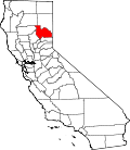
Plumas County California Incorporated and Unincorporated areas Valley Ranch Highlighted.svg
Location in Plumas County and the state of California
Usa edcp location map.svg
Red pog.svg
Valley Ranch
Location in the United States
Coordinates: 39°44′18″N120°34′4″W / 39.73833°N 120.56778°W / 39.73833; -120.56778 Coordinates: 39°44′18″N120°34′4″W / 39.73833°N 120.56778°W / 39.73833; -120.56778
Country Flag of the United States.svg  United States
State Flag of California.svg  California
County Plumas
Area
[1]
  Total1.137 sq mi (2.945 km2)
  Land1.137 sq mi (2.945 km2)
  Water0 sq mi (0 km2)  0%
Elevation
4,436 ft (1,352 m)
Population
 (2010)
  Total109
  Density96/sq mi (37/km2)
Time zone UTC-8 (Pacific (PST))
  Summer (DST) UTC-7 (PDT)
ZIP code
96106
Area code(s) 530
FIPS code 06-81869
GNIS feature ID1853419

Valley Ranch is a census-designated place in Plumas County, California, United States. The population was 109 at the 2010 census, up from 92 at the 2000 census.

Contents

Geography

Valley Ranch is located at 39°44′18″N120°34′4″W / 39.73833°N 120.56778°W / 39.73833; -120.56778 (39.738392, -120.567839). [2]

According to the United States Census Bureau, the CDP has a total area of 1.3 square miles (3.4 km2), all of it land.

Demographics

2010

At the 2010 census Valley Ranch had a population of 109. The population density was 95.8 inhabitants per square mile (37.0/km2). The racial makeup of Valley Ranch was 107 (98.2%) White, 0 (0.0%) African American, 0 (0.0%) Native American, 0 (0.0%) Asian, 0 (0.0%) Pacific Islander, 1 (0.9%) from other races, and 1 (0.9%) from two or more races. Hispanic or Latino of any race were 2 people (1.8%). [3]

The whole population lived in households, no one lived in non-institutionalized group quarters and no one was institutionalized.

There were 58 households, 5 (8.6%) had children under the age of 18 living in them, 39 (67.2%) were opposite-sex married couples living together, 2 (3.4%) had a female householder with no husband present, 2 (3.4%) had a male householder with no wife present. There were 1 (1.7%) unmarried opposite-sex partnerships, and 2 (3.4%) same-sex married couples or partnerships. 11 households (19.0%) were one person and 4 (6.9%) had someone living alone who was 65 or older. The average household size was 1.88. There were 43 families (74.1% of households); the average family size was 2.09.

The age distribution was 5 people (4.6%) under the age of 18, 0 people (0%) aged 18 to 24, 6 people (5.5%) aged 25 to 44, 49 people (45.0%) aged 45 to 64, and 49 people (45.0%) who were 65 or older. The median age was 63.8 years. For every 100 females, there were 101.9 males. For every 100 females age 18 and over, there were 92.6 males.

There were 82 housing units at an average density of 72.1 per square mile, of the occupied units 54 (93.1%) were owner-occupied and 4 (6.9%) were rented. The homeowner vacancy rate was 0%; the rental vacancy rate was 33.3%. 104 people (95.4% of the population) lived in owner-occupied housing units and 5 people (4.6%) lived in rental housing units.

2000

At the 2000 census there were 92 people, 42 households, and 39 families in the CDP. The population density was 54.6 inhabitants per square mile (21.1/km2). There were 52 housing units at an average density of 30.9 per square mile (11.9/km2). The racial makeup of the CDP was 100.00% White. Hispanic or Latino of any race were 2.17%. [4]

Of the 42 households 11.9% had children under the age of 18 living with them, 88.1% were married couples living together, 2.4% had a female householder with no husband present, and 4.8% were non-families. 4.8% of households were one person and none had someone living alone who was 65 or older. The average household size was 2.19 and the average family size was 2.20.

The age distribution was 7.6% under the age of 18, 5.4% from 18 to 24, 8.7% from 25 to 44, 52.2% from 45 to 64, and 26.1% 65 or older. The median age was 57 years. For every 100 females, there were 114.0 males. For every 100 females age 18 and over, there were 107.3 males.

The median household income was $82,736 and the median family income was $82,736. Males had a median income of $61,250 versus $17,679 for females. The per capita income for the CDP was $32,505. None of the population and none of the families were below the poverty line.

Media

The primary local news source is the Portola Reporter, a newspaper published every Wednesday.

Politics

In the state legislature, Valley Ranch is in the 1st Senate District , represented by Republican Brian Dahle, [5] and the 1st Assembly District , represented by Republican Megan Dahle. [6]

Federally, Valley Ranch is in California's 1st congressional district , represented by Republican Doug LaMalfa. [7]

Related Research Articles

Mesquite Creek, Arizona CDP in Mohave County, Arizona

Mesquite Creek is an unincorporated community and census-designated place (CDP) in Mohave County, Arizona, United States. The population was 403 at the 2020 census.

Mojave Ranch Estates, Arizona CDP in Mohave County, Arizona

Mojave Ranch Estates is an unincorporated community and census-designated place (CDP) in Mohave County, Arizona, United States. The population was 53 as of the 2020 census.

Vail, Arizona CDP in Pima County, Arizona

Vail is a census-designated place (CDP) in Pima County, Arizona, United States. It is 24 miles (39 km) southeast of Tucson. The population was 10,208 at the 2010 census, up from 2484 in the 2000 census. The area is known for the nearby Colossal Cave, a large cave system, and the Rincon Mountains District of Saguaro National Park, a top tourism spot within Arizona.

<span class="mw-page-title-main">Bear Valley Springs, California</span> Census-designated place in California, United States

Bear Valley Springs is a guarded-gate community in Kern County, California, United States. Bear Valley Springs is in the Tehachapi Mountains and is part of the greater Tehachapi area. The elevation ranges from 4,121 feet (1,256 m) to 6,934 feet (2,113 m). The population fluctuates between a low during the winter months when snow is common, to a high in the summer months when its elevation keeps it much cooler than surrounding areas and major cities. The population was 5,172 at the 2010 census, up from 4,232 at the 2000 census. For statistical purposes, the United States Census Bureau has defined Bear Valley Springs as a census-designated place (CDP). The census definition of the area may not precisely correspond to local understanding of the area with the same name.

<span class="mw-page-title-main">Valley Acres, California</span> Census-designated place in California, United States

Valley Acres is a census-designated place (CDP) in Kern County, California, United States. Valley Acres is located 5.2 miles (8.4 km) north-northeast of Taft, at an elevation of 420 feet (128.02 m). The population was 527 at the 2010 census, up from 512 at the 2000 census.

Lake Wildwood, California Census-designated place in California, United States

Lake Wildwood is a census-designated place (CDP) in Nevada County, California, United States. The population was 4,991 at the 2010 census, up from 4,868 at the 2000 census.

<span class="mw-page-title-main">Penn Valley, California</span> Census-designated place in California, United States

Penn Valley is a census-designated place (CDP) in Nevada County, California. The population was 1,621 at the 2010 census, up from 1,387 at the 2000 census.

<span class="mw-page-title-main">Foothill Ranch, California</span> Human settlement in California, United States of America

Foothill Ranch is a master planned community in Orange County, California, United States. The population was 10,899 at the 2000 census. Foothill Ranch was incorporated into the city of Lake Forest, California, in 2000. Prior to that, it was a census-designated place.

Beckwourth, California Census-designated place in California, United States

Beckwourth is a census-designated place (CDP) in Plumas County, California, United States. Beckwourth is located on the Middle Fork Feather River 5 miles (8.0 km) east of Portola. The population was 432 at the 2010 census, up from 342 at the 2000 census.

Crescent Mills, California Census-designated place in California, United States

Crescent Mills is a census-designated place (CDP) in Plumas County, California, United States. Crescent Mills is located 3.5 miles (5.6 km) southeast of Greenville. The population was 196 at the 2010 census, down from 258 at the 2000 census.

Meadow Valley, California Census-designated place in California, United States

Meadow Valley is a census-designated place (CDP) in Plumas County, California, United States. The population was 453 at the 2020 census, down from 464 at the 2010 census.

Casa de Oro-Mount Helix, California Census designated place in California, United States

Casa de Oro-Mount Helix is a census-designated place (CDP) in the East County region of San Diego County, California.

<span class="mw-page-title-main">Spring Valley, San Diego County, California</span> Census-designated place in California, United States

Spring Valley is a census-designated place (CDP) in the East County region of San Diego County, California. The population was 28,205 at the 2010 census.

Lake Arrowhead is a census-designated place (CDP) in the towns of Waterboro and Limerick in York County, Maine, United States. The population was 3,071 at the 2010 census. The CDP corresponds to the area covered by the Lake Arrowhead Community, a large subdivision begun in the 1960s which surrounds Lake Arrowhead, an artificial lake on the Little Ossipee River. The community is part of the Portland–South Portland–Biddeford, Maine Metropolitan Statistical Area.

Spanish Springs is a census-designated place (CDP) in Washoe County, Nevada, United States. It is located in the northeastern part of the Reno–Sparks Metropolitan Statistical Area. The population was 15,064 at the 2010 Census.

Pleasant Run, Ohio Census-designated place in Ohio, United States

Pleasant Run is a census-designated place (CDP) in Hamilton County, Ohio, United States. The population was 4,953 at the 2010 census.

Ravine is a census-designated place (CDP) in Schuylkill County, Pennsylvania, United States. The population was 629 at the 2000 census.

Burton, South Carolina CDP in South Carolina, United States

Burton is a census-designated place (CDP) on Port Royal Island in Beaufort County, South Carolina, United States. The population was 6,976 at the 2010 census. As defined by the U.S. Census Bureau, Burton is included within the Hilton Head Island-Bluffton-Beaufort, SC Metropolitan Statistical Area.

Green Valley, South Dakota CDP in South Dakota, United States

Green Valley is a census-designated place (CDP) and unincorporated community in Pennington County, South Dakota, United States. The population was 1,051 at the 2020 census.

Star Valley Ranch, Wyoming Town in Wyoming, United States

Star Valley Ranch is a town in Lincoln County, Wyoming, United States. The population was 1,503 at the 2010 census. It was incorporated on November 8, 2005; at the 2000 census, it was only a census-designated place (CDP).

References

  1. "U.S. Census". Archived from the original on 2012-01-25. Retrieved 2012-07-08.
  2. "US Gazetteer files: 2010, 2000, and 1990". United States Census Bureau. 2011-02-12. Retrieved 2011-04-23.
  3. "2010 Census Interactive Population Search: CA - Valley Ranch CDP". U.S. Census Bureau. Archived from the original on July 15, 2014. Retrieved July 12, 2014.
  4. "U.S. Census website". United States Census Bureau . Retrieved 2008-01-31.
  5. "Senators". State of California. Retrieved March 10, 2013.
  6. "Members Assembly". State of California. Retrieved March 2, 2013.
  7. "California's 1st Congressional District - Representatives & District Map". Civic Impulse, LLC. Retrieved March 3, 2013.