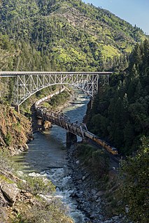
Graeagle is a census-designated place (CDP) located about 60 miles (97 km) from Reno, Nevada and 46 miles (74 km) from Truckee, California in Plumas County, California, United States. The population was 737 at the 2010 census, down from 831 at the 2000 census.

The Feather River is the principal tributary of the Sacramento River, in the Sacramento Valley of Northern California. The river's main stem is about 73 miles (117 km) long. Its length to its most distant headwater tributary is just over 210 miles (340 km). The main stem Feather River begins in Lake Oroville, where its four long tributary forks join together—the South Fork, Middle Fork, North Fork, and West Branch Feather Rivers. These and other tributaries drain part of the northern Sierra Nevada, and the extreme southern Cascades, as well as a small portion of the Sacramento Valley. The total drainage basin is about 6,200 square miles (16,000 km2), with approximately 3,604 square miles (9,330 km2) above Lake Oroville.

Plumas Lake is a master-planned exurb and census-designated place in Yuba County, California. Plumas Lake is located 30 miles (48 km) north of the city of Sacramento on the Feather River, just prior to its confluence with the Bear River and the Sacramento River. At full build-out the city will have roughly 12,000 homes and 36,000 residents. The community is located about 10 miles (16 km) south of the city of Marysville in southern Yuba County. It lies at an elevation of 46 feet. The population was 5,853 at the 2010 census.

Vinton is an unincorporated community in Plumas County, California. It lies at an elevation of 4,947 feet (1,508 m). Vinton is located 2 miles (3.2 km) west of Chilcoot.

Chilcoot is an unincorporated community in Plumas County, California. It lies at an elevation of 5,013 feet (1,528 m). Chilcoot is located 17 miles (27.4 km) east of Portola.

Las Plumas is a former settlement in Butte County, California.

Two Rivers is an unincorporated community in Plumas County, California. It lies at an elevation of 4324 feet. Two Rivers is located near where Jamison Creek joins the Middle Fork Feather River, 4 miles (6.4 km) northwest of Blairsden.

Chases is a former settlement in Plumas County, California. It lay at an elevation of 5400 feet. Chases is located in Red Clover Valley 6 miles (9.7 km) east-southeast of Mount Ingalls.

Edmanton is a former settlement in Plumas County, California. It lay at an elevation of 4741 feet. Edmanton is located on Big Creek, 2.5 miles (4.0 km) southwest of Meadow Valley.

Feather River Inn is a historic Alpine-style Lodge in Plumas County, California. It lies at an elevation of 4462 feet. Feather River Inn is located on California State Route 89 and California State Route 70. It is located 1 mile (1.6 km) northwest of Blairsden.

Five Points is an unincorporated community in Plumas County, California. It lies at an elevation of 6804 feet. Five Points is located 6.5 miles (10.5 km) north-northeast of Blairsden.

Massack is an unincorporated community in Plumas County, California. It lies at an elevation of 3642 feet. Massack is located on the Western Pacific Railroad, 3.5 miles (5.6 km) northwest of Spring Garden. California State Route 89 runs through Massack.

Moccasin is an unincorporated community in Plumas County, California. It lies at an elevation of 3517 feet. Moccasin is located on the Western Pacific Railroad, 2.25 miles (3.6 km) southwest of Crescent Mills.

Mohawk is an unincorporated community in Plumas County, California. It lies at an elevation of 4360 feet. Mohawk is located 1 mile (1.6 km) west of Blairsden.
Dutch Hill is a former settlement in Plumas County, California. Dutch Hill is located 1.5 miles (2.4 km) west-northwest of Seneca.

Silver Creek is a former settlement in Plumas County, California. It lay at an elevation of 3724 feet. Silver Creek is located 1.25 miles (2.0 km) north-northwest of Meadow Valley.

Sloat is an unincorporated community in Plumas County, California. It lies at an elevation of 4131 feet. Sloat is located on the Western Pacific Railroad, 8.5 miles (13.7 km) northwest of Blairsden.

Squirrel Creek is a former settlement in Plumas County, California. It lay at an elevation of 5407 feet. Squirrel Creek is located 8 miles (12.9 km) west-northwest of Clio. It still appeared on maps as of 1897.
Wonderland is a former settlement in Plumas County, California. It was a vacation resort 12 miles (19.3 km) northwest of Chester.


