
The Ku-ring-gai Chase National Park is a protected national park that is located in New South Wales, Australia. The 14,977-hectare (37,010-acre) national park is situated 25 kilometres (16 mi) north of Sydney located largely within the Ku-ring-gai, Hornsby, and the Northern Beaches Council local government areas. The villages of Cottage Point, Appletree Bay, and Bobbin Head are located within park boundaries. An isolated portion of the park, Barrenjoey Headland, is located to the north of Palm Beach east of the primary park body and is home to Barrenjoey Lighthouse.

The Geographic Names Information System (GNIS) is a database that contains name and locative information about more than two million physical and cultural features located throughout the United States of America and its territories. It is a type of gazetteer. GNIS was developed by the United States Geological Survey in cooperation with the United States Board on Geographic Names (BGN) to promote the standardization of feature names.

The Hokan language family is a hypothetical grouping of a dozen small language families that were spoken mainly in California, Arizona and Baja California. In over a century since the "Hokan" hypothesis was first proposed by Roland B. Dixon and Alfred L. Kroeber, and further elaborated by Edward Sapir, little additional evidence has been found that these families were related to each other. Although some Hokan families may indeed be related, especially in northern California, few linguists today expect Hokan as a whole to prove to be valid.

Harold Homer Chase, nicknamed "Prince Hal", was a first baseman and manager in Major League Baseball, widely viewed as the best fielder at his position. During his career, he played for the New York Highlanders (1905–1913), Chicago White Sox (1913–1914), Buffalo Blues (1914–1915), Cincinnati Reds (1916–1918), and New York Giants (1919).
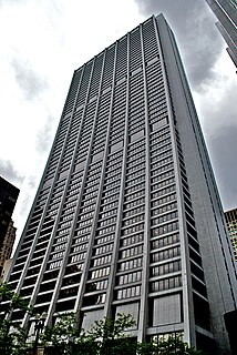
Chase Tower, located in the Chicago Loop area of Chicago, in the U.S. state of Illinois at 10 South Dearborn Street, is a 60-story skyscraper completed in 1969. At 869 feet tall, it is the eleventh-tallest building in Chicago, the tallest building inside the Chicago 'L' Loop elevated tracks, and the 40th-tallest in the United States. Chase Bank has its U.S. and Canada commercial and retail banking headquarters here. The building is also the headquarters of Exelon. The building and its plaza occupy the entire block bounded by Clark, Dearborn, Madison, and Monroe streets.

Akuna Bay is an urban place in Sydney, Australia. Akuna Bay is located 38 kilometres (24 mi) north of the Sydney central business district, in the local government area of Northern Beaches Council.
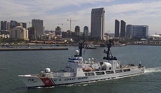
USCGC Chase (WHEC-718) was a Hamilton class High Endurance Cutter of the United States Coast Guard. She was laid down on October 26, 1966 at Avondale Shipyards in New Orleans, launched on May 20, 1967 and commissioned on March 11, 1968. Chase is the fourth of twelve Hamilton Class, 378-foot (115 m) cutters, and the third cutter named in honor of Salmon Portland Chase. She was decommissioned on March 29, 2011 and transferred to the Nigerian Navy as an excess defense article under the Foreign Assistance Act as NNS Thunder (F90).

Newberry Springs is an unincorporated community in the western Mojave Desert of Southern California, located at the foot of the Newberry Mountains in San Bernardino County, California, United States. The population at the 2000 census was 2,895.

Merrimac is an unincorporated community in Butte County, California located along Oroville-Quincy Road about 2.1 miles (3.4 km) south of the Plumas County line. It lies at an elevation of 3999 feet. While the location is shown as official in the National Geographic Names Database, it is not known if locals use this name to describe the place today. Nearby is Rogers Cow Camp, a campground in Lassen National Forest. The USGS feature ID for this populated place is 1659117. The US Postal Service does not show a ZIP Code for this community. The location is within area code 530.

Nat Geo People, formerly known as Adventure One (A1) and National Geographic Adventure, is a subscription TV channel part of National Geographic Channels International and 21st Century Fox. Targeted at female audiences, with programming focusing on people and cultures, the channel is available in 50 countries in both linear and non-linear formats.

J. Smeaton Chase was an English-born American author, traveler and photographer.
Ragtown was a mining town, now a ghost town, in the Mojave Desert, San Bernardino County, California, United States. John Sutter found gold in the Bagdad-Chase area in about 1898.

Hambrecht & Quist (H&Q) was an investment bank based in San Francisco, California noted for its focus on the technology and Internet sectors. H&Q was founded by William Hambrecht and George Quist in California, in 1968.
Nelson is an unincorporated community in Butte County, California. It lies 6.5 miles (10.5 km) south-southeast of Durham, at an elevation of 121 feet. Nelson's first post office was established in 1873; its zip code is 95958. The place was founded in 1873 by the California and Oregon Railroad Company and named for an early settler, A.D. Nelson.
New Blinzing is a former settlement in Butte County, California, United States. It was located 5.25 miles north of Berry Creek and about 1 mile (1.6 km) northwest of Blinzing, on the Western Pacific Railroad, at an elevation of 942 feet. It still appeared on maps as of 1948.
Wicks Corner is an unincorporated community in Butte County, California, at the junction of California State Route 70 and California State Route 149. It lies at an elevation of 272 feet.
Petersburg is a former settlement in Kern County, California. It was located on Greenhorn Creek 4.5 miles (7.2 km) west-northwest of Miracle Hot Springs, at an elevation of 4731 feet. Petersburg still appeared on maps as of 1956.
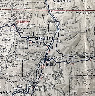
Kernville is a former settlement in the Kern River Valley of the Sierra Nevada, in Kern County, California.
Saltdale is an unincorporated community in Kern County, California. It is located near Koehn Lake 21 miles (34 km) south-southwest of Ridgecrest near Garlock, California.
Glenblair is an unincorporated community in Mendocino County, California. It is located 15 miles (24 km) north-northwest of Comptche, at an elevation of 207 feet.


