Indian Falls | |
---|---|
Coordinates: 40°3′3″N120°58′48″W / 40.05083°N 120.98000°W | |
Country | United States |
State | California |
County | Plumas |
Area | |
• Total | 1.842 [3] sq mi (4.770 km2) |
• Land | 1.842 sq mi (4.770 km2) |
• Water | 0 sq mi (0 km2) 0% |
Elevation | 3,258 ft (993 m) |
Population (2020) | |
• Total | 10 |
• Density | 5.4/sq mi (2.1/km2) |
Time zone | UTC-8 (Pacific (PST)) |
• Summer (DST) | UTC-7 (PDT) |
ZIP code | 95952 |
Area code | 530 |
FIPS code | 06-36364 |
GNIS feature ID | 1656088 |
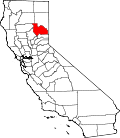
Indian Falls is a census-designated place (CDP) in Plumas County, California, United States. The population was 10 at the 2020 census, down from 54 at the 2010 census.
Indian Falls is located at 40°3′3″N120°58′48″W / 40.05083°N 120.98000°W (40.050816, -120.979897). [4]
According to the United States Census Bureau, the CDP has a total area of 1.8 square miles (4.7 km2), all of it land.
It was named after a set of waterfalls on Indian Creek.
Much of the town was destroyed from the Dixie Fire of July 13, 2021.
Census | Pop. | Note | %± |
---|---|---|---|
U.S. Decennial Census [5] |
The 2010 United States Census [6] reported that Indian Falls had a population of 54. The population density was 29.3 inhabitants per square mile (11.3/km2). The racial makeup of Indian Falls was 50 (92.6%) White, 0 (0.0%) African American, 0 (0.0%) Native American, 1 (1.9%) Asian, 0 (0.0%) Pacific Islander, 1 (1.9%) from other races, and 2 (3.7%) from two or more races. Hispanic or Latino of any race were 4 people (7.4%).
The whole population lived in households, no one lived in non-institutionalized group quarters and no one was institutionalized.
There were 24 households, 7 (29.2%) had children under the age of 18 living in them, 15 (62.5%) were opposite-sex married couples living together, 1 (4.2%) had a female householder with no husband present, 1 (4.2%) had a male householder with no wife present. There were 1 (4.2%) unmarried opposite-sex partnerships, and 0 (0%) same-sex married couples or partnerships. 6 households (25.0%) were one person and 1 (4.2%) had someone living alone who was 65 or older. The average household size was 2.25. There were 17 families (70.8% of households); the average family size was 2.65.
The age distribution was 12 people (22.2%) under the age of 18, 1 people (1.9%) aged 18 to 24, 13 people (24.1%) aged 25 to 44, 26 people (48.1%) aged 45 to 64, and 2 people (3.7%) who were 65 or older. The median age was 45.3 years. For every 100 females, there were 134.8 males. For every 100 females age 18 and over, there were 121.1 males.
There were 33 housing units at an average density of 17.9 per square mile, of the occupied units 22 (91.7%) were owner-occupied and 2 (8.3%) were rented. The homeowner vacancy rate was 0%; the rental vacancy rate was 0%. 51 people (94.4% of the population) lived in owner-occupied housing units and 3 people (5.6%) lived in rental housing units.
The 2000 census [7] reported there were 37 people, 19 households, and 9 families in the CDP. The population density was 20.5 people per square mile (7.9/km2). There were 24 housing units at an average density of 13.3 per square mile (5.1/km2). The racial makeup of the CDP was 97.30% White and 2.70% Asian. 0.00% of the population were Hispanic or Latino of any race.
Of the 19 households 26.3% had children under the age of 18 living with them, 42.1% were married couples living together, 10.5% had a female householder with no husband present, and 47.4% were non-families. 31.6% of households were one person and 5.3% were one person aged 65 or older. The average household size was 1.95 and the average family size was 2.40.
The age distribution was 16.2% under the age of 18, 2.7% from 18 to 24, 32.4% from 25 to 44, 37.8% from 45 to 64, and 10.8% 65 or older. The median age was 44 years. For every 100 females, there were 117.6 males. For every 100 females age 18 and over, there were 93.8 males.
The median household income was $7,321 and the median family income was $18,750. Males had a median income of $0 versus $0 for females. The per capita income for the CDP was $5,936. There were no families and 31.8% of the population living below the poverty line, including no under eighteens and 100.0% of those over 64.
In the state legislature, Indian Falls is in the 1st Senate District , represented by Republican Brian Dahle, [8] and the 1st Assembly District , represented by Republican Megan Dahle. [9]
Federally, Indian Falls is in California's 1st congressional district , represented by Republican Doug LaMalfa. [10]
West Puente Valley is an unincorporated community and census-designated place in Los Angeles County, California, USA, northwest of La Puente. The population was 22,636 at the 2010 census, up from 22,589 at the 2000 census. The community is probably named for its location related to the city of La Puente.
Lake of the Pines is a census-designated place (CDP) and a gated residential community in Nevada County, California, United States. The population was 3,917 at the 2010 census.
Keddie is a census-designated place in Plumas County, California, United States. The population was 66 at the 2010 census.
Paxton is a census-designated place (CDP) in Plumas County, California, United States. The population was 14 at the 2010 census, down from 21 at the 2000 census.
Taylorsville is a census-designated place (CDP) in Plumas County, California, United States. The population was 150 at the 2010 census, down from 154 at the 2000 census. The annual Stone Ranch Reunion is held in Taylorsville.
Pine Valley is a community and census-designated place (CDP) in the Cuyamaca Mountains of the Mountain Empire area, in southeastern San Diego County, California. The population was 1,510 at the 2010 census, up from 1,501 at the 2000 census.
August is a census-designated place (CDP) in San Joaquin County, California, United States. The population was 8,628 at the 2020 census, up from 8,390 at the 2010 census.
Grenada is a census-designated place (CDP) in Siskiyou County, California, United States. Its population is 314 as of the 2020 census, down from 367 from the 2010 census. The ZIP code is 96038 and the community is within area code 530.
Jamestown is a census-designated place (CDP) in Tuolumne County, California, United States. The population was 3,433 at the 2010 census, up from 3,017 at the 2000 census. Formerly a California Gold Rush town, Jamestown is a California Historical Landmark since March 16, 1949. It is the home of Railtown 1897 State Historic Park and the Sierra Railway, which operates steam passenger trains.
Potomac Heights is a census-designated place (CDP) in Charles County, Maryland, United States. The population was 1,117 at the 2010 census. It has a volunteer fire department and numerous older rambler homes built for workers at the nearby U.S. Navy munitions plant in Indian Head.
Glens Falls North is a census-designated place (CDP) in Warren County, New York, United States. It is part of the Glens Falls Metropolitan Statistical Area. The CDP population was 9,530 at the 2020 census. It lies north of the city of Glens Falls, in the town of Queensbury.
Valley Falls is a village and census-designated place (CDP) in the town of Cumberland, Providence County, Rhode Island, United States. The population was 12,094 at the 2020 census.
Oak Grove is a census-designated place (CDP) in Lexington County, South Carolina, United States. The population was 10,291 at the 2010 census. It is part of the Columbia Metropolitan Statistical Area.
Great Falls is a census-designated place in Fairfax County, Virginia, United States. The population at the 2020 census was 15,953.
Merrifield is a census-designated place (CDP) in Fairfax County, Virginia, United States. The population was 20,488 at the 2020 census.
Cassville is a census-designated place (CDP) in Monongalia County, West Virginia, United States. The population was 1,268 at the 2020 census. It is included in the Morgantown, West Virginia Metropolitan Statistical Area. Cassville was named after Lewis Cass, a prominent American statesman who served as Secretary of War, Secretary of State, and Governor of Michigan.
Arapahoe is a census-designated place (CDP) in Fremont County, Wyoming, United States. The population was 1,656 at the 2010 census. A Catholic mission was founded here in 1884. St Stephen's Mission Church, located near Arapahoe, is part of the Catholic mission.
Holland is a hamlet and census-designated place (CDP) in Erie County, New York, United States. The population was 1,206 at the 2010 census. It is in the town of Holland and is part of the Buffalo–Niagara Falls Metropolitan Statistical Area.
West Seneca is a hamlet and census-designated place (CDP) in Erie County, New York, United States. The population was 44,711 at the 2010 census. It is part of the Buffalo–Niagara Falls Metropolitan Statistical Area. The CDP corresponds exactly to the area of the town of West Seneca.
Livermore Falls is a census-designated place (CDP) in the town of Livermore Falls in Androscoggin County, Maine, United States. The population of the CDP was 1,594 at the 2010 census, out of a population of 3,187 within the full town.