Mohawk Vista, California

Last updated
Mohawk Vista
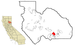
Plumas County California Incorporated and Unincorporated areas Mohawk Vista Highlighted.svg
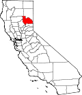
Location in Plumas County and the state of California
Usa edcp location map.svg
Red pog.svg
Mohawk Vista
Location in the United States
Coordinates: 39°46′54″N120°34′49″W / 39.78167°N 120.58028°W / 39.78167; -120.58028 Coordinates: 39°46′54″N120°34′49″W / 39.78167°N 120.58028°W / 39.78167; -120.58028
Country Flag of the United States.svg  United States
State Flag of California.svg  California
County Plumas
Area
[1]
  Total11.961 sq mi (30.979 km2)
  Land11.961 sq mi (30.979 km2)
  Water0 sq mi (0 km2)  0%
Elevation
4,944 ft (1,507 m)
Population
 (2010)
  Total159
  Density13/sq mi (5.1/km2)
Time zone UTC-8 (Pacific (PST))
  Summer (DST) UTC-7 (PDT)
ZIP code
96103
Area code(s) 530
FIPS code 06-48448
GNIS feature ID1853401

Mohawk Vista is a census-designated place in Plumas County, California, United States. The population was 159 at the 2010 census, up from 121 at the 2000 census.

Contents

Geography

Mohawk Vista is located at 39°46′54″N120°34′49″W / 39.78167°N 120.58028°W / 39.78167; -120.58028 (39.781650, -120.580343). [2]

According to the United States Census Bureau, the CDP has a total area of 12.0 square miles (31 km2), all of it land.

Demographics

2010

At the 2010 census Mohawk Vista had a population of 159. The population density was 13.3 people per square mile (5.1/km2). The racial makeup of Mohawk Vista was 146 (91.8%) White, 0 (0.0%) African American, 1 (0.6%) Native American, 7 (4.4%) Asian, 0 (0.0%) Pacific Islander, 1 (0.6%) from other races, and 4 (2.5%) from two or more races. Hispanic or Latino of any race were 4 people (2.5%). [3]

The whole population lived in households, no one lived in non-institutionalized group quarters and no one was institutionalized.

There were 74 households, 9 (12.2%) had children under the age of 18 living in them, 42 (56.8%) were opposite-sex married couples living together, 2 (2.7%) had a female householder with no husband present, 4 (5.4%) had a male householder with no wife present. There were 7 (9.5%) unmarried opposite-sex partnerships, and 0 (0%) same-sex married couples or partnerships. 19 households (25.7%) were one person and 10 (13.5%) had someone living alone who was 65 or older. The average household size was 2.15. There were 48 families (64.9% of households); the average family size was 2.48.

The age distribution was 16 people (10.1%) under the age of 18, 9 people (5.7%) aged 18 to 24, 18 people (11.3%) aged 25 to 44, 65 people (40.9%) aged 45 to 64, and 51 people (32.1%) who were 65 or older. The median age was 59.3 years. For every 100 females, there were 96.3 males. For every 100 females age 18 and over, there were 104.3 males.

There were 102 housing units at an average density of 8.5 per square mile, of the occupied units 62 (83.8%) were owner-occupied and 12 (16.2%) were rented. The homeowner vacancy rate was 3.1%; the rental vacancy rate was 14.3%. 138 people (86.8% of the population) lived in owner-occupied housing units and 21 people (13.2%) lived in rental housing units.

2000

At the 2000 census there were 121 people, 55 households, and 36 families in the CDP. The population density was 10.2 people per square mile (3.9/km2). There were 88 housing units at an average density of 7.4 per square mile (2.9/km2). The racial makeup of the CDP was 98.35% White and 1.65% Native American. Hispanic or Latino of any race were 0.83%. [4]

Of the 55 households 18.2% had children under the age of 18 living with them, 56.4% were married couples living together, 7.3% had a female householder with no husband present, and 34.5% were non-families. 32.7% of households were one person and 5.5% were one person aged 65 or older. The average household size was 2.20 and the average family size was 2.72.

The age distribution was 18.2% under the age of 18, 7.4% from 18 to 24, 16.5% from 25 to 44, 45.5% from 45 to 64, and 12.4% 65 or older. The median age was 49 years. For every 100 females, there were 105.1 males. For every 100 females age 18 and over, there were 106.3 males.

The median household income was $40,893 and the median family income was $55,833. Males had a median income of $31,750 versus $30,714 for females. The per capita income for the CDP was $20,172. None of the population and none of the families were below the poverty line.

Politics

In the state legislature, Mohawk Vista is in the 1st Senate District , represented by Republican Brian Dahle, [5] and the 1st Assembly District , represented by Republican Megan Dahle. [6]

Federally, Mohawk Vista is in California's 1st congressional district , represented by Republican Doug LaMalfa. [7]

Related Research Articles

Funny River, Alaska Census-designated place in Alaska, United States

Funny River is a census-designated place (CDP) in Kenai Peninsula Borough, Alaska, United States. At the 2010 census the population was 877, up from 636 in 2000.

Mesa Vista, California census-designated place in California, United States

Mesa Vista is a census-designated place (CDP) in Alpine County, California, United States. The population was 200 at the 2010 census, up from 182 at the 2000 census.

Ford City, California census-designated place in California, United States

Ford City is a census-designated place (CDP) in Kern County, California, United States. Ford City is located 1 mile (1.61 km) north of Taft, at an elevation of 892 feet (272 m). The population was 4,278 at the 2010 census, up from 3,512 at the 2000 census. It is immediately north of Taft, between the huge Midway-Sunset Oil Field to the southwest, and the almost exhausted Buena Vista Oil Field to the northeast. State Route 119 passes east of town from its junction with SR 33 to the south.

Meadow Vista, California census-designated place in California, United States

Meadow Vista is a census-designated place (CDP) in Placer County, California, United States. It is part of the Sacramento–Arden-Arcade–Roseville Metropolitan Statistical Area. The population was 3,217 at the 2010 census, up from 3,096 at the 2000 census.

Tahoe Vista, California census-designated place in California, United States

Tahoe Vista is a census-designated place located on the north shore of Lake Tahoe in Placer County, California. It is part of the Sacramento–Arden-Arcade–Roseville Metropolitan Statistical Area. The population was 1,433 at the 2010 census, down from 1,668 at the 2000 census.

Lake Almanor West, California census-designated place in California, United States

Lake Almanor West is a census-designated place (CDP) in Plumas County, California, United States. The population was 270 at the 2010 census, down from 329 at the 2000 census.

Valle Vista, California census-designated place in California, United States

Valle Vista is a census-designated place (CDP) in Riverside County, California, United States and is located in the San Jacinto Valley. Some areas of Valle Vista are considered to be part of both unincorporated San Jacinto and Hemet but have yet to be incorporated. The population was 11,036 at the 2010 census, up from 8,356 at the 2000 census.

Bonsall, California Census-designated place in California, United States

Bonsall is a census-designated place (CDP) in San Diego County, California. The population was 3,982 at the 2010 census, up from 3,401 at the 2000 census.

Buena Vista, San Jose Neighborhood of San Jose in Santa Clara, California, United States

Buena Vista is a former census-designated place (CDP) in Santa Clara County, California, United States. The population was 1,704 at the 2000 census. The area is now part of the city of San Jose.

Mono Vista, California census-designated place in California, United States

Mono Vista is a census-designated place (CDP) in Tuolumne County, California, United States. The population was 3,127 at the 2010 census, up from 3,072 at the 2000 census.

Bayou Vista, Louisiana Census-designated place in Louisiana, United States

Bayou Vista is a census-designated place (CDP) in St. Mary Parish, Louisiana, United States. The population was 4,652 at the 2010 census. It is part of the Morgan City Micropolitan Statistical Area.

Flora Vista, New Mexico CDP in New Mexico, United States

Flora Vista is a census-designated place (CDP) in San Juan County, New Mexico, United States. The population was 1,383 at the 2000 census. It is part of the Farmington Metropolitan Statistical Area. Flora Vista was founded in 1877 by settlers from Colorado who built cabins along the Animas River. A post office was established the following year. The name derived from the view of wildflowers in the valley.

Tribes Hill, New York CDP in New York, United States

Tribes Hill is a census-designated place (CDP) located in the Towns of Mohawk (80%) and Amsterdam (20%) in Montgomery County, New York, United States. The population was 1,003 at the 2010 census. One theory is the name is based on this location having been a gathering spot for the Mohawk nation, the dominant Iroquois tribe in the area during colonial times.

Blue Berry Hill, Texas Census-designated place in Texas, United States

Blueberry Hill is a census-designated place (CDP) in Bee County, Texas, United States. The population was 866 at the 2010 census. It is located just outside Beeville and has no services of its own. Drinking water and garbage services are provided by the city of Beeville. Mailing addresses for Blueberry Hill are labeled "Beeville".

Chula Vista-Orason, Texas Former CDP in Texas, United States

Chula Vista-Orason was a census-designated place (CDP) in Cameron County, Texas, United States. The population was 394 at the 2000 census. For the 2010 census the area was split into two CDPs, Chula Vista and Orason. The communities are part of the Brownsville–Harlingen Metropolitan Statistical Area.

Chula Vista, Maverick County, Texas CDP in Texas, United States

Chula Vista, formerly known as Rosita North, is a census-designated place (CDP) in Maverick County, Texas, United States. The population was 3,400 at the 2000 census.

Larga Vista, Texas Former CDP in Texas, United States

Larga Vista is a former census-designated place (CDP) in Webb County, Texas, United States. The population was 742 at the 2000 census. Larga Vista lost its census-designated place status in 2010 because it became surrounded by Laredo, Texas. A CDP may not be located, either partially or entirely, within an incorporated place or another CDP. Today, Larga Vista is considered a Laredo neighborhood.

Mount Vista, Washington Census-designated place in Washington, United States

Mount Vista is a census-designated place (CDP) in Clark County, Washington, United States. It includes the Vancouver campus of Washington State University. The population of Mount Vista was 7,850 at the 2010 census, up from 5,770 at the 2000 census.

Vista West, Wyoming CDP in Wyoming, United States

Vista West is a census-designated place (CDP) in Natrona County, Wyoming, United States. It is part of the Casper, Wyoming Metropolitan Statistical Area. The population was 951 at the 2010 census.

Pittsfield (CDP), Maine CDP in Maine, United States

Pittsfield is a census-designated place (CDP) in the town of Pittsfield in Somerset County, Maine, United States. The population was 3,217 at the 2000 census.

References

  1. U.S. Census Archived 2012-01-25 at the Wayback Machine
  2. "US Gazetteer files: 2010, 2000, and 1990". United States Census Bureau. 2011-02-12. Retrieved 2011-04-23.
  3. "2010 Census Interactive Population Search: CA - Mohawk Vista CDP". U.S. Census Bureau. Archived from the original on July 15, 2014. Retrieved July 12, 2014.
  4. "U.S. Census website". United States Census Bureau . Retrieved 2008-01-31.
  5. "Senators". State of California. Retrieved March 10, 2013.
  6. "Members Assembly". State of California. Retrieved March 2, 2013.
  7. "California's 1st Congressional District - Representatives & District Map". Civic Impulse, LLC. Retrieved March 3, 2013.