Greenhorn | |
---|---|
Coordinates: 39°54′21″N120°44′55″W / 39.90583°N 120.74861°W | |
Country | United States |
State | California |
County | Plumas |
Area | |
• Total | 6.711 sq mi (17.381 km2) |
• Land | 6.711 sq mi (17.381 km2) |
• Water | 0 sq mi (0 km2) 0% |
Elevation | 4,436 ft (1,352 m) |
Population (2010) | |
• Total | 236 |
• Density | 35/sq mi (14/km2) |
Time zone | UTC-8 (Pacific (PST)) |
• Summer (DST) | UTC-7 (PDT) |
ZIP code | 95971 |
Area code | 530 |
FIPS code | 06-31029 |
GNIS feature ID | 1853393 |
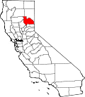
Greenhorn is a census-designated place (CDP) in Plumas County, California, United States. The population was 236 at the 2010 census, up from 146 at the 2000 census.
Greenhorn is located at 39°54′21″N120°44′55″W / 39.90583°N 120.74861°W (39.905794, -120.748665). [2]
According to the United States Census Bureau, the CDP has a total area of 6.7 square miles (17 km2), all of it land.
Census | Pop. | Note | %± |
---|---|---|---|
U.S. Decennial Census [3] |
At the 2010 census Greenhorn had a population of 236. The population density was 35.2 inhabitants per square mile (13.6/km2). The racial makeup of Greenhorn was 213 (90.3%) White, 1 (0.4%) African American, 7 (3.0%) Native American, 2 (0.8%) Asian, 0 (0.0%) Pacific Islander, 6 (2.5%) from other races, and 7 (3.0%) from two or more races. Hispanic or Latino of any race were 22 people (9.3%). [4]
The whole population lived in households, no one lived in non-institutionalized group quarters and no one was institutionalized.
There were 106 households, 23 (21.7%) had children under the age of 18 living in them, 56 (52.8%) were opposite-sex married couples living together, 4 (3.8%) had a female householder with no husband present, 4 (3.8%) had a male householder with no wife present. There were 7 (6.6%) unmarried opposite-sex partnerships, and 1 (0.9%) same-sex married couples or partnerships. 33 households (31.1%) were one person and 9 (8.5%) had someone living alone who was 65 or older. The average household size was 2.23. There were 64 families (60.4% of households); the average family size was 2.81.
The age distribution was 43 people (18.2%) under the age of 18, 15 people (6.4%) aged 18 to 24, 47 people (19.9%) aged 25 to 44, 88 people (37.3%) aged 45 to 64, and 43 people (18.2%) who were 65 or older. The median age was 46.9 years. For every 100 females, there were 96.7 males. For every 100 females age 18 and over, there were 103.2 males.
There were 140 housing units at an average density of 20.9 per square mile, of the occupied units 95 (89.6%) were owner-occupied and 11 (10.4%) were rented. The homeowner vacancy rate was 6.9%; the rental vacancy rate was 8.3%. 211 people (89.4% of the population) lived in owner-occupied housing units and 25 people (10.6%) lived in rental housing units.
At the 2000 census there were 146 people, 64 households, and 40 families in the CDP. The population density was 21.7 inhabitants per square mile (8.4/km2). There were 84 housing units at an average density of 12.5 per square mile (4.8/km2). The racial makeup of the CDP was 94.52% White, 0.68% Native American, and 4.79% from two or more races. 4.79% of the population were Hispanic or Latino of any race. [5] Of the 64 households 25.0% had children under the age of 18 living with them, 59.4% were married couples living together, 1.6% had a female householder with no husband present, and 37.5% were non-families. 29.7% of households were one person and 14.1% were one person aged 65 or older. The average household size was 2.28 and the average family size was 2.85.
The age distribution was 23.3% under the age of 18, 3.4% from 18 to 24, 32.9% from 25 to 44, 28.8% from 45 to 64, and 11.6% 65 or older. The median age was 43 years. For every 100 females, there were 114.7 males. For every 100 females age 18 and over, there were 124.0 males.
The median household income was $151,513 and the median family income was $151,053. Males had a median income of $136,250 versus $14,625 for females. The per capita income for the CDP was $21,525. None of the population and none of the families were below the poverty line.
In the state legislature, Greenhorn is in the 1st Senate District , represented by Republican Brian Dahle, [6] and the 1st Assembly District , represented by Republican Megan Dahle. [7]
Federally, Greenhorn is in California's 1st congressional district , represented by Republican Doug LaMalfa. [8]
Diablo is a census-designated place (CDP) in Contra Costa County, California, United States. The population was 1,158 at the 2010 census. It is located 2.5 miles (4.0 km) east-northeast of Danville.
Mountain View is a census designated place (CDP) in Contra Costa County, California, United States. The population was 2,372 at the 2010 census.
Bodfish is a census-designated place (CDP) in the southern Kern River Valley of the Southern Sierra Nevada, in Kern County, California.
Dustin Acres is a census-designated place (CDP) in Kern County, California, United States. Dustin Acres is located 6.5 miles (10 km) north-northeast of Taft, at an elevation of 384 feet (117 m). The population was 652 at the 2010 census, up from 585 at the 2000 census.
South Taft is a census-designated place (CDP) in Kern County, California, United States. South Taft is located 0.5 miles (0.8 km) south of Taft, at an elevation of 1,017 feet (310 m). The population was 2,169 at the 2010 census, up from 1,898 at the time of the 2000 census.
Valley Acres is a census-designated place (CDP) in Kern County, California, United States. Valley Acres is located 5.2 miles (8.4 km) north-northeast of Taft, at an elevation of 420 feet (128.02 m). The population was 527 at the 2010 census, up from 512 at the 2000 census.
Wofford Heights is a census-designated place (CDP) in the southern Sierra Nevada, in Kern County, California, United States. Wofford Heights is located in the west Kern River Valley, 3.5 miles (5.6 km) south-southwest of Kernville, at an elevation of 2,684 feet (818 m). The population was 2,200 at the 2010 census, down from 2,276 at the 2000 census.
Desert View Highlands is a census-designated place (CDP) in Los Angeles County, California, United States. The population was 2,360 at the 2010 census, up from 2,337 at the 2000 census. It is surrounded by the City of Palmdale.
North El Monte is a census-designated place (CDP) in the San Gabriel Valley, in Los Angeles County, California, United States. The population was 3,723 at the 2010 census, up from 3,703 at the 2000 census.
Granite Bay is a census-designated place (CDP) in Placer County, California, United States. It is part of the Sacramento–Arden-Arcade–Roseville Metropolitan Statistical Area. The population was 21,247 at the 2020 census, up from 20,402 at the 2010 census. The ZIP codes are 95746 and 95661. Granite Bay is a primarily residential suburb of Sacramento and is located just east of Roseville and west of Folsom Lake.
North Auburn is a census-designated place (CDP) in Placer County, California, United States. It is part of the Sacramento–Arden-Arcade–Roseville Metropolitan Statistical Area. The population was 13,452 at the 2020 census.
Keddie is a census-designated place in Plumas County, California, United States. The population was 66 at the 2010 census.
Lake Almanor Peninsula is a census-designated place (CDP) in Plumas County, California, United States. The population was 356 at the 2010 census, up from 336 at the 2000 census.
Lake Almanor West is a census-designated place (CDP) in Plumas County, California, United States. The population was 270 at the 2010 census, down from 329 at the 2000 census.
Plumas Eureka is a census-designated place (CDP) in Plumas County, California, United States. The population was 320 at the 2000 census.
Fruitdale is a district of San Jose, California, located in West San Jose, though some portions are still unincorporated as a census-designated place. The population of the CDP was 935 at the 2010 census.
Terra Bella is a census-designated place (CDP) in Tulare County, California, United States. The population was 2,910 at the 2020 census, down from 3,310 at the 2010 census.
China Lake Acres is a census-designated place (CDP) in Kern County, California, United States. The population was 1,876 at the 2010 census, up from 1,761 at the 2000 census.
Covedale is a census-designated place (CDP) in Green Township, Hamilton County, Ohio, United States. The population was 6,472 at the 2020 census. The CDP represents the part of the former village of Covedale that was not annexed by the city of Cincinnati in the 1890s.
Northbrook is a census-designated place (CDP) in Hamilton County, Ohio, United States. The population was 10,912 at the 2020 census.