Tennant, California

Last updated
Tennant
Siskiyou County California Incorporated and Unincorporated areas Tennant Highlighted.svg
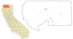
Location in Siskiyou County and the state of California
Usa edcp location map.svg
Red pog.svg
Tennant
Location in the United States
Coordinates: 41°35′6″N121°54′42″W / 41.58500°N 121.91167°W / 41.58500; -121.91167 Coordinates: 41°35′6″N121°54′42″W / 41.58500°N 121.91167°W / 41.58500; -121.91167
Country Flag of the United States.svg  United States of America
State Flag of California.svg  California
County Flag of Siskiyou County, California.png Siskiyou
Area
[1]
  Total0.243 sq mi (0.629 km2)
  Land0.243 sq mi (0.628 km2)
  Water0.000 sq mi (0.001 km2)  0.19%
Elevation
4,797 ft (1,462 m)
Population
 (2020)
  Total63
  Density260/sq mi (100/km2)
Time zone UTC-8 (Pacific (PST))
  Summer (DST) UTC-7 (PDT)
ZIP code
96012
Area code(s) 530
FIPS code 06-78176
GNIS feature ID1659968

Tennant is a census-designated place (CDP) in Siskiyou County, California, United States. Its population is 63 as of the 2020 census, up from 41 from the 2010 census.

Contents

Geography

Tennant is located at 41°35′6″N121°54′42″W / 41.58500°N 121.91167°W / 41.58500; -121.91167 (41.585003, -121.911794). [2]

According to the United States Census Bureau, the CDP has a total area of 0.2 square miles (0.52 km2), 99.81% of it land and 0.19% of it water.

Climate

This region experiences warm (but not hot) and dry summers, with no average monthly temperatures above 71.6 °F. According to the Köppen Climate Classification system, Tennant has a warm-summer Mediterranean climate, abbreviated "Csb" on climate maps. [3]

Demographics

2010

The 2010 United States Census [4] reported that Tennant had a population of 41. The population density was 168.7 inhabitants per square mile (65.1/km2). The racial makeup of Tennant was 36 (87.8%) White, 0 (0.0%) African American, 2 (4.9%) Native American, 0 (0.0%) Asian, 0 (0.0%) Pacific Islander, 1 (2.4%) from other races, and 2 (4.9%) from two or more races. Hispanic or Latino of any race were 4 persons (9.8%).

The Census reported that 41 people (100% of the population) lived in households, 0 (0%) lived in non-institutionalized group quarters, and 0 (0%) were institutionalized.

There were 27 households, out of which 1 (3.7%) had children under the age of 18 living in them, 8 (29.6%) were opposite-sex married couples living together, 0 (0%) had a female householder with no husband present, 2 (7.4%) had a male householder with no wife present. There were 1 (3.7%) unmarried opposite-sex partnerships, and 0 (0%) same-sex married couples or partnerships. 15 households (55.6%) were made up of individuals, and 8 (29.6%) had someone living alone who was 65 years of age or older. The average household size was 1.52. There were 10 families (37.0% of all households); the average family size was 2.00.

The population was spread out, with 1 people (2.4%) under the age of 18, 1 people (2.4%) aged 18 to 24, 6 people (14.6%) aged 25 to 44, 21 people (51.2%) aged 45 to 64, and 12 people (29.3%) who were 65 years of age or older. The median age was 59.5 years. For every 100 females, there were 156.3 males. For every 100 females age 18 and over, there were 150.0 males.

There were 89 housing units at an average density of 366.3 per square mile (141.4/km2), of which 20 (74.1%) were owner-occupied, and 7 (25.9%) were occupied by renters. The homeowner vacancy rate was 0%; the rental vacancy rate was 0%. 31 people (75.6% of the population) lived in owner-occupied housing units and 10 people (24.4%) lived in rental housing units.

2000

As of the census [5] of 2000, there were 63 people, 34 households, and 17 families residing in the CDP. The population density was 289.7 inhabitants per square mile (111.9/km2). There were 96 housing units at an average density of 441.4 per square mile (170.4/km2). The racial makeup of the CDP was 88.89% White, 1.59% Native American, 3.17% from other races, and 6.35% from two or more races. Hispanic or Latino of any race were 11.11% of the population.

There were 34 households, out of which 8.8% had children under the age of 18 living with them, 38.2% were married couples living together, 11.8% had a female householder with no husband present, and 50.0% were non-families. 44.1% of all households were made up of individuals, and 26.5% had someone living alone who was 65 years of age or older. The average household size was 1.85 and the average family size was 2.53.

In the CDP, the population was spread out, with 12.7% under the age of 18, 3.2% from 18 to 24, 17.5% from 25 to 44, 36.5% from 45 to 64, and 30.2% who were 65 years of age or older. The median age was 56 years. For every 100 females, there were 80.0 males. For every 100 females age 18 and over, there were 83.3 males.

The median income for a household in the CDP was $10,750, and the median income for a family was $26,250. Males had a median income of $21,250 versus $0 for females. The per capita income for the CDP was $9,929. There were 31.3% of families and 34.8% of the population living below the poverty line, including 100.0% of under eighteens and 8.3% of those over 64.

100% of the population speaks English. [6]

Politics

In the state legislature Tennant is in the 1st Senate District , represented by Republican Brian Dahle, [7] and the 1st Assembly District , represented by Republican Megan Dahle. [8]

Federally, Tennant is in California's 1st congressional district , represented by Republican Doug LaMalfa. [9]

Related Research Articles

Onyx, California Census-designated place in California, United States

Onyx is a census-designated place (CDP) in Kern County, California, United States. Onyx is located 3.5 miles (6 km) east-northeast of Weldon in the South Fork Valley at an elevation of 2,795 feet (852 m). The population was 475 at the 2010 census, down from 476 at the 2000 census.

Meadow Vista, California Census-designated place in California, United States

Meadow Vista is a census-designated place (CDP) in Placer County, California, United States. It is part of the Sacramento–Arden-Arcade–Roseville Metropolitan Statistical Area. The population was 3,217 at the 2010 census, up from 3,096 at the 2000 census.

North Auburn, California Census-designated place in California, United States

North Auburn is a census-designated place (CDP) in Placer County, California, United States. It is part of the Sacramento–Arden-Arcade–Roseville Metropolitan Statistical Area. The population was 13,022 at the 2010 census, up from 11,847 at the 2000 census.

Belden, California Census-designated place in California, United States

Belden is a census-designated place (CDP) in Plumas County, California, United States. Belden is located on the North Fork Feather River, 7 miles (11.3 km) southwest of Caribou. The population was 22 at the 2010 census, down from 26 in 2000.

Hamilton Branch, California Census-designated place in California, United States

Hamilton Branch is a census-designated place (CDP) in Plumas County, California, United States. The population was 587 at the 2000 census.

Lake Almanor Country Club, California Census-designated place in California, United States

Lake Almanor Country Club is a census-designated place (CDP) in Plumas County, California, United States. The population was 419 at the 2010 census, down from 847 at the 2000 census. The ZIP code for the CDP is 96137.

Meadow Valley, California Census-designated place in California, United States

Meadow Valley is a census-designated place (CDP) in Plumas County, California, United States. The population was 453 at the 2020 census, down from 464 at the 2010 census.

<span class="mw-page-title-main">Prattville, California</span> Census-designated place in California, United States

Prattville is a census-designated place (CDP) in Plumas County, California, United States. The population was 33 at the 2010 census, up from 28 at the 2000 census.

<span class="mw-page-title-main">Foothill Farms, California</span> Census-designated place in California, United States

Foothill Farms is a census-designated place (CDP) and unincorporated community in Sacramento County, California, USA. It is part of the Sacramento–Arden-Arcade–Roseville Metropolitan Statistical Area. The population was 33,121 at the 2010 census, up from 17,426 at the 2000 census. Foothill Farms is part of the greater North Highlands-Foothill Farms community, and comprises the zip codes 95841 and 95842. Susan Ual services as President of the New Foothill Farms Community Association while Michael Baker services as the President of the Old Foothill Farms Community Association

www.oldfoothillfarms.org
Kennedy, California Census-designated place in California, United States

Kennedy is a census-designated place (CDP) in San Joaquin County, California, United States. The population was 3,356, at the 2020 census, up from 3,254 at the 2000 census.

Lockeford, California Census-designated place in California, United States

Lockeford is an unincorporated community in San Joaquin County, California, United States. For statistical purposes, the United States Census Bureau has defined Lockeford as a census-designated place (CDP). The census definition of the area may not precisely correspond to local understanding of the area with the same name. The population was 3,521 at the 2020 census, up from 3,233 at the 2010 census.

<span class="mw-page-title-main">Taft Mosswood, California</span> Census-designated place in California, United States

Taft Mosswood is a census-designated place (CDP) in San Joaquin County, California, United States. The population was 1,530 at the 2010 census, up from 1,388 at the 2000 census. It comprises an unincorporated "island" within the City of Stockton.

East Foothills, San Jose Census designated place in California, United States

East Foothills is a census-designated place (CDP) in Santa Clara County, California, United States and a neighborhood of San Jose. The population was 8,269 at the 2010 census and it is located about 4 miles east of downtown San Jose.

Fruitdale, San Jose Place in California, United States

Fruitdale is a district of San Jose, California, located in West San Jose, though some portions are still unincorporated as a census-designated place. The population of the CDP was 935 at the 2010 census.

Freedom, California Census-designated place in California, United States

Freedom is a census-designated place (CDP) in Santa Cruz County, California, United States. The population was 3,070 at the 2010 census.

Opal Cliffs, California Unincorporated community in California, United States

Opal Cliffs is an unincorporated community in Santa Cruz County, California, United States.

McArthur, California Census-designated place in California, United States

McArthur is a census-designated place (CDP) in Shasta County, California, United States. Its population is 334 as of the 2020 census, down from 338 from the 2010 census. McArthur is a small ranching community, located 4 mi east of Fall River Mills.

Macdoel, California Census-designated place in California

Macdoel is a census-designated place (CDP) in Siskiyou County, California, United States. Macdoel is located on U.S. Route 97 approximately halfway between Klamath Falls, Oregon and Weed. Its population is 86 as of the 2020 census, down from 133 from the 2010 census.

Grayson, California Census-designated place in California, United States

Grayson is a census-designated place (CDP) in Stanislaus County, California, United States. The population was 952 at the 2010 census, down from 1,077 at the 2000 census. It is part of the Modesto Metropolitan Statistical Area.

North Sultan, Washington CDP in Washington, United States

North Sultan is a census-designated place (CDP) in Snohomish County, Washington, United States. The population was 264 at the 2010 census.

References

  1. U.S. Census Archived 2012-01-25 at the Wayback Machine
  2. "US Gazetteer files: 2010, 2000, and 1990". United States Census Bureau. 2011-02-12. Retrieved 2011-04-23.
  3. Climate Summary for Tennant, California
  4. "2010 Census Interactive Population Search: CA - Tennant CDP". U.S. Census Bureau. Archived from the original on July 15, 2014. Retrieved July 12, 2014.
  5. "U.S. Census website". United States Census Bureau . Retrieved 2008-01-31.
  6. Census 2005, 01-15-09
  7. "Senators". State of California. Retrieved March 10, 2013.
  8. "Members Assembly". State of California. Retrieved March 2, 2013.
  9. "California's 1st Congressional District - Representatives & District Map". Civic Impulse, LLC. Retrieved March 1, 2013.