Weed, California

Last updated

Weed, California
City of Weed
Weed CA.jpg
Entrance to Weed in 2004, with Mount Shasta in the background
Siskiyou County California Incorporated and Unincorporated areas Weed Highlighted.svg
Location in Siskiyou County and the U.S. state of California
Usa edcp relief location map.png
Red pog.svg
Weed, California
Location in the contiguous United States
Coordinates: 41°25′27″N122°23′4″W / 41.42417°N 122.38444°W / 41.42417; -122.38444
Country Flag of the United States.svg United States
State Flag of California.svg  California
County Siskiyou
Incorporated January 25, 1961 [1]
Government
  MayorSusan Tavalero
  Mayor Pro TemStacey Green
Area
[2]
  Total4.79 sq mi (12.40 km2)
  Land4.78 sq mi (12.38 km2)
  Water0.01 sq mi (0.01 km2)  0.10%
Elevation
3,425 ft (1,044 m)
Population
 (2020)
  Total2,862
  Density600/sq mi (230/km2)
Time zone UTC-8 (Pacific (PST))
  Summer (DST) UTC-7 (PDT)
ZIP code
96094
Area code 530
FIPS code 06-83850
GNIS feature ID1652650
Website www.ci.weed.ca.us

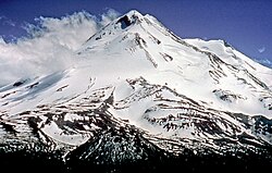
Weed is a city in Siskiyou County, California, United States. As of the 2020 Census, the city had a total population of 2,862, down from 2,967 in 2010. There are several unincorporated communities adjacent to, or just outside, Weed proper, including Edgewood, Carrick, and Lake Shastina. These communities generally have mailing addresses that use Weed or its ZIP code. Weed is about 10 miles (16 km) west-northwest of Mount Shasta, a prominent northern California landmark, and the second-tallest volcano in the Cascade Range.

Contents

Weed's city motto is "Weed like to welcome you". [3] Weed has frequently been noted on lists of unusual place names. [4]

History

Statue of Abner Weed, founder and namesake of the city Abner Weed statue, Centennial Plaza, Weed, California.jpg
Statue of Abner Weed, founder and namesake of the city

The City of Weed derives its name from the founder of the local lumber mill and pioneer Abner Weed, who discovered that the area's strong winds were helpful in drying lumber. In 1897, Abner Weed bought the Siskiyou Lumber and Mercantile Mill and 280 acres (110 hectares) of land in what is now the City of Weed, for $400. [5] By the 1940s Weed boasted the world's largest sawmill.[ citation needed ]

Boles Fire

On September 15, 2014, the Boles Fire spread through Weed, driven by 40-mph winds. The fire started behind the Boles Creek Apartments in the central part of Weed at approximately 1:30 p.m., and within four hours quickly spread to over 200 acres (80 hectares). Evacuations were immediately ordered, and a shelter was first set up at College of the Siskiyous, but as fire headed towards the college, the evacuation center was relocated first to the Siskiyou Golden Fairgrounds in Yreka, then to Yreka and Mount Shasta High Schools, then to the armory in Mt. Shasta.

Over 200 structures were damaged or destroyed, including two churches, the elementary school, high school, and Roseburg mill. The schools and mill sustained only minimal damage to outbuildings. About 7,678 Pacific Power customers in both Weed and Mt. Shasta lost power as a result of the fire. [6]

Beaughan Spring

The City of Weed gets its water from the Beaughan Spring, with the water being piped directly to homes.

In September 2016, The New York Times reported that French billionaire Pierre Papillaud demanded that Weed give up its Beaughan Spring spring water source so that Papillaud's bottle water company could have more water to sell. Disconnecting from Beaughan Spring would leave Weed without public water. [7] In March 2021, it was reported that the parties involved had reached a compromise which will allow Weed to continue to have access to water from Beaughan Spring in perpetuity. [8]

Mill Fire

In early September 2022, the Mill Fire started in or near Weed, burning down the Lincoln Heights neighborhood. [9]

Geography

Weed is off Interstate 5, 49 miles (79 km) south of the CaliforniaOregon border. The next large settlement to the north on I-5 is Yreka; to the south is the City of Mount Shasta. U.S. Route 97 runs to the northeast and Klamath Falls, Oregon.

According to the United States Census Bureau, [10] the city has a total area of 4.8 square miles (12 km2), of which 0.10% is covered by water. The closest cities with a population greater than 50,000 are Redding, California (69 miles south) and Medford, Oregon (91 miles north).

Climate

Weed has a warm-summer Mediterranean climate (Csb according to the Köppen climate classification system), featuring cool, wet winters with occasional snowfall, and hot, dry summers. [11] Its average annual precipitation is 23.64 in (600 mm). [12] Its USDA hardiness zone is 7b. [13]

Weed (1971-2000 normals)
Climate chart (explanation)
J
F
M
A
M
J
J
A
S
O
N
D
 
 
3.7
 
 
44
24
 
 
3.3
 
 
49
28
 
 
3.5
 
 
54
30
 
 
1.9
 
 
60
33
 
 
1.4
 
 
68
38
 
 
0.8
 
 
77
44
 
 
0.3
 
 
85
48
 
 
0.4
 
 
85
48
 
 
0.5
 
 
78
41
 
 
1.4
 
 
66
34
 
 
3.1
 
 
51
29
 
 
3.7
 
 
44
25
Average max. and min. temperatures in °F
Precipitation totals in inches
Source: Western Regional Climate Center [12]
Metric conversion
J
F
M
A
M
J
J
A
S
O
N
D
 
 
93
 
 
7
−5
 
 
84
 
 
9
−2
 
 
90
 
 
12
−1
 
 
48
 
 
16
1
 
 
35
 
 
20
3
 
 
21
 
 
25
7
 
 
8.1
 
 
29
9
 
 
11
 
 
29
9
 
 
12
 
 
25
5
 
 
35
 
 
19
1
 
 
79
 
 
10
−2
 
 
93
 
 
6
−4
Average max. and min. temperatures in °C
Precipitation totals in mm

Transportation

Weed is at the intersection of Interstate 5 and U.S. Route 97. Interstate 5 is the primary north–south transportation corridor for the west coast of the United States running from the Mexico–US border to the Canada–US border. U.S. Route 97 is a major north-south U.S. highway continuing from Weed in a northeasterly direction toward Klamath Falls, Oregon, thence through Oregon and Washington to the Canada–US border. California State Route 265 also runs through the City of Weed, locally known as North Weed Boulevard. Only two blocks long, it is the second-shortest state highway in California.

Route 265 CA 265 trailblazer.JPG
Route 265

Weed is served by Siskiyou County's public transportation bus lines, Siskiyou Transit and General Express, commonly called "The STAGE". [14]

The closest airports for commercial air travel are Rogue Valley International-Medford Airport and Redding Municipal Airport. The Weed Airport serves general aviation and as a base of operations for search and rescue operations on Mount Shasta. Corporate visitors or geological researchers typically use this facility.

Amtrak trains pass through Weed, but do not stop there. The Amtrak bus/shuttle has one stop in South Weed. The nearest depot for Amtrak train travel is in Dunsmuir, approximately 15 miles (24 km) to the south.

Greyhound Bus Lines has a bus station, with both north and southbound buses making stops.

Economy

From its founding in 1901, to as late as the 1980s, Weed was home to a thriving lumber industry. Roseburg Forest Products (plywood), International Paper Company, Morgan Products Ltd. (wooden door manufacturing), and J.H. Baxter (wood treatment) were all based in Weed. The historic industrial area at the northeast corner of Weed has been plagued with environmental concerns and clean-up efforts as a result of chemicals used for wood treatment, as well as chemical residue from glue used in the door factory. [15]

Mt. Shasta Brewing Company.jpg
Mt. Shasta Brewing Company in Weed, California
Mt. Shasta Brewing Company - Lemurian Lager.jpg
Lemurian Lager

Although historically reliant on logging, wood processing and forest-related products, Weed's economy has become more reliant on tourism as a source of economic activity. Weed's microbrewery, Mt. Shasta Brewing Company, relies on tourists for 92 percent of its business, according to co-owner Vaune Dillman. [16]

Today, most of the wood-product-related industry has been scaled back or ceased altogether, and new retail and light industrial activity is concentrated in the southeast corner of Weed. Retail at the south end of Weed, in the form of restaurants and hotels, caters primarily to tourist travel on the Interstate 5 corridor. Light manufacturing of bottled water from Crystal Geyser Water Company has also added economic stability to the area.[ citation needed ]

Weed is part of the Shasta Valley Enterprise Zone which provides tax breaks, fee reductions, and permit fast-tracking for employers locating in the area. [17]

As of 2007, the largest employers in Weed were:

As a small community with few retail outlets, taxable sales within the city are somewhat limited, totaling $89 million in 2012. [18]

In the November 2014 general election, the voters of Weed passed Measure J, which raised the city's sales and use tax rate by 0.25 percent. [19]

Education

College of the Siskiyous, Weed, California College of the Siskiyous.jpg
College of the Siskiyous, Weed, California
Weed High School billboard Weed High School billboard.jpg
Weed High School billboard

Primary education in Weed is conducted at Weed Elementary School (K-8th grade). Butteville Elementary School (K-8th grade) is just outside the City of Weed, in the hamlet of Edgewood, and has an enrollment similar to Weed Elementary.

Secondary-level students are educated at Weed High School (grades 9–12), part of the Siskiyou Union High School District. The school is known for its picturesque campus and diverse student body. [20]

The College of the Siskiyous, located in Weed, provides a steady source of employment for faculty and staff, a source of visitors for the local economy, and offers a two-year junior college education with various associate degree and vocational certificate programs.

Recreation and tourism

Visitors use Weed as a base to engage in trout fishing in the nearby Klamath, [21] Sacramento [21] [22] [23] and McCloud [21] [22] Rivers, or come to see and climb Mount Shasta, Castle Crags or the Trinity Alps. [24] Visitors also engage in nearby skiing (both alpine and cross-country) and biking, or hike to the waterfalls, streams and lakes in the area, including nearby Mossbrae Falls, Lake Siskiyou, Castle Lake and Shasta Lake. [24]

The town's name, being the same as a slang term for cannabis, has caused it to gain a small notoriety. [25] Many shops have popped up around town selling shirts and other trinkets that say "I Love Weed, California".

Recreation facilities and parks

Weed is near Castle Crags State Park, Lava Beds National Monument, and Lower Klamath National Wildlife Refuge. In addition to these state and federal parks, there are numerous local recreation opportunities.

Historic sites and museums

Demographics

Historical population
CensusPop.Note
1950 2,739
1960 3,22317.7%
1970 2,983−7.4%
1980 2,879−3.5%
1990 3,0626.4%
2000 2,978−2.7%
2010 2,967−0.4%
2020 2,862−3.5%
U.S. Decennial Census [30]

2010

The 2010 United States Census [31] reported that Weed had a population of 2,967. The population density was 618.9 inhabitants per square mile (239.0/km2). The racial makeup of Weed was 2,221 (74.9 percent) white, 206 (6.9 percent) African-American, 70 (2.4 percent) Native American, 121 (4.1 percent) Asian, 27 (0.9 percent) Pacific Islander, 132 (4.4 percent) from other races, and 190 (6.4 percent) from two or more races. Hispanic or Latino of any race were 475 persons (16.0 percent).

The census reported that 2,820 people (95.0 percent of the population) lived in households, 101 (3.4 percent) lived in non-institutionalized group quarters, and 46 (1.6%) were institutionalized.

There were 1,131 households, out of which 385 (34 percent) had children under the age of 18 living in them, 447 (39.5 percent) were opposite-sex married couples living together, 188 (16.6 percent) had a female householder with no husband present, 81 (7.2 percent) had a male householder with no wife present. There were 103 (9.1 percent) unmarried opposite-sex partnerships, and 2 (0.2 percent) same-sex married couples or partnerships. Three hundred-eleven households (27.5 percent) were made up of individuals, and 125 (11.1 percent) had someone living alone who was 65 years of age or older. The average household size was 2.49. There were 716 families (63.3 percent of all households); the average family size was 3.02.

The population was spread out, with 735 people (24.8 percent) under the age of 18, 460 people (15.5 percent) aged 18 to 24, 660 people (22.2 percent) aged 25 to 44, 698 people (23.5 percent) aged 45 to 64, and 414 people (14 percent) who were 65 years of age or older. The median age was 32.7 years. For every 100 females, there were 100.7 males. For every 100 females age 18 and over, there were 100 males.

There were 1,273 housing units at an average density of 265.5 per square mile (102.5/km2), of which 543 (48 percent) were owner-occupied, and 588 (52 percent) were occupied by renters. The homeowner vacancy rate was 3.3%; the rental vacancy rate was 8.8 percent. Forty-three percent of the population (1,275 persons) lived in owner-occupied housing units and 1,545 people (52.1 percent) lived in rental housing units.

2000

As of the census of 2000, there were 2,978 people, 1,184 households, and 747 families residing in the city. The population density was 613.4 people per square mile (237.1 km2). There were 1,293 housing units at an average density of 266.3 per square mile (102.9 km2). The racial makeup of the city was 73.27 percent white, 9.27 percent Black or African American, 1.95 percent Native American, 4.57 percent Asian, 0.47 percent Pacific Islander, 5.51 percent from other races, and 4.97 percent from two or more races. Hispanic or Latino people of any race made up 12.76 percent of the population.

The number of violent crimes recorded by the FBI in 2003 was 25. The number of murders and homicides was one. The violent crime rate was 8.5 per 1,000 people.

One of Weed's main streets Weed, California, USA 001.jpg
One of Weed's main streets

In the city, age distribution was spread out, with 25.6 percent under the age of 18, 14.4 percent from 18 to 24, 22.6 percent from 25 to 44, 20.2 percent from 45 to 64, and 17.2 percent who were 65 years of age or older. The median age was 35 years. For every 100 females, there were 94.8 males. For every 100 females age 18 and over, there were 93.3 males.

The median income for a household in the city was $23,333, and the median income for a family was $32,197. Males had a median income of $29,052 versus $21,894 for females. The per capita income for the city was $12,434. Below the poverty line: 23.9 percent of the population and 17.2 percent of families. Of the total population, 30.9 percent of those under the age of 18 and 4.9 percent of those 65 and older were living below the poverty line.

Traffic: The average commute time for Weed workers is 12 minutes, compared with 26 minutes nationwide.

Housing: Median rent in Weed, at the time of the 2000 Census, was $348. Monthly mortgages were $676. Average monthly rent in all of California is $1341.

Education: seven percent of Weed residents age 25 and older have a bachelor's or advanced college degree.

Of the population 84.97 percent spoke English as their primary language, while 15.02 percent did not; of those 9.87 percent speak Spanish, 2.90 speak Italian, and 2.23 percent speak Laotian. One hundred percent of the population speaks English. [32]

Ethnic migration

Weed's historic lumber industry and manufacturing facilities made it a magnet for ethnic minority migration, that may not have otherwise been the case in this region of the country. A large number of Italian immigrants migrated to Weed, and other towns in southern Siskiyou County at the turn of the 20th century. While immigrants were a source of labor for the region, they were not always well treated, in fact in 1909 complaints from workers in the lumber industry reached the Italian consul. [33] However, in time the Italian population came to be a cornerstone of Weed civic life. Many streets in the early Italian neighborhood bear names of Italian cities, such as Rome, Genoa, Como, and Venice. Annually since 1954, Weed has held the Weed Italian Carnevale in June or July, although recently dropping "Italian" from its name while maintaining the Italian spelling of carnival and the traditional bocce ball tournaments. [34]

A large number of black-Americans migrated to Weed as well, to work in Long-Bell Lumber Company's Weed facility after the company closed two mills in Louisiana in 1922. The company promised to advance travel expenses and provide housing for workers relocating to Weed. [35] Immigrants locating in Weed since the 1980s have come primarily from Mexico and Laos. As a result of these migrations, Weed has a much more ethnically diverse population than Siskiyou County as a whole. Netting the Hispanic or Latino population out of Census figures for white race, Weed's white population is 60.6 percent compared to Siskiyou County at 79.5 percent using the same metric. [36]

Politics

The city council of Weed is composed of five members who are elected at large and serve four-year terms. The Mayor and Mayor Pro Tem are elected each year from the five council members and serve a one-year term. Susan Tavalero is currently serving as Mayor of Weed until November 2020, with Stacey Green serving as Mayor Pro Tem. [37]

In the state legislature Weed is in the 1st Senate District , represented by Republican Brian Dahle, [38] and the 1st Assembly District , represented by Republican Megan Dahle. [39]

Federally, Weed is in California's 1st congressional district , represented by Republican Doug LaMalfa. [40]

In Siskiyou County Supervisoral District 3, in which Weed is the core community, voter registration was 39.6 percent Democrat, 39.1 percent Republican, 16.2 percent decline to state, with remainder split among other political parties such as Green and Libertarian as of 2006. [41]

Notable people

Local media

John Steinbeck's novella-play Of Mice and Men begins with the protagonists, George and Lennie, fleeing a farm they worked at in Weed after Lennie got into trouble.

Weed is the setting of a large subplot in Harry Turtledove's alternate history The Hot War .

Footnotes

  1. "California Cities by Incorporation Date". California Association of Local Agency Formation Commissions. Archived from the original (Word) on November 3, 2014. Retrieved August 25, 2014.
  2. "2019 U.S. Gazetteer Files". United States Census Bureau. Retrieved July 1, 2020.
  3. Griffin, Pete (May 26, 2011). "What's In a Name? Slogans Can Make or Break a City, Experts Say". Fox News. Retrieved March 19, 2014.
  4. Parker, Quentin (2010). Welcome to Horneytown, North Carolina, Population: 15: An insider's guide to 201 of the world's weirdest and wildest places. Adams Media. p. 189. ISBN   9781440507397.
  5. "Weed Now and Then" http://www.snowcrest.net/whm/Weed1.html
  6. Fuller, Thomas (October 1, 2016). "Timber Company Tells California Town, Go Find Your Own Water". New York Times. Retrieved October 2, 2016.
  7. Meyer, Mike (March 12, 2021). "'A historic day': Weed strikes deal for water source after years long battle". Mount Shasta News. Retrieved March 20, 2021.
  8. Ryan Sabalow; Dale Kasler (September 3, 2022). "'Everybody on that street knew everybody.' Wildfire destroys historic Black section of Weed". Sacramento Bee. Archived from the original on December 2, 2022.
  9. Bureau, US Census. "Census.gov". Census.gov. Retrieved June 26, 2022.
  10. "Weed, California". Weatherbase. Köppen Classification: Mediterran Climate
  11. 1 2 "NCDC 1971-2000 Monthly Normals". wrcc.dri.edu. WEED FIRE DEPT, CALIFORNIA.
  12. "ZIP Code 96094 - Weed, California". Zipdatamaps.com. Retrieved November 1, 2023.
  13. "Siskiyou Transit and General Express". Co.siskiyou.ca.us. August 1, 2011. Archived from the original on December 10, 2012. Retrieved December 16, 2012.
  14. "J.H. BAXTER & CO. – WEED, CA". Superfund. EPA. Retrieved November 2, 2023.
  15. McManis, Sam (October 20, 2011). "Town's name is joke fodder, but Weed rolls with it" . Mercury News.
  16. "Shasta Valley Enterprise Zone". Archived from the original on August 22, 2009.
  17. "Taxable Sales in California by City, 2012". State Board of Equalization.
  18. "City of Weed Sales Tax Increase, Measure J (November 2014)".
  19. "Siskiyou Union High School District". Siskiyou.schoolwisepress.com. Archived from the original on February 20, 2012. Retrieved December 16, 2012.
  20. 1 2 3 Siskiyou County information site Archived August 17, 2009, at the Wayback Machine accessed February 21, 2008.
  21. 1 2 Ross, John (2005). Trout Unlimited's Guide to America's 100 Best Trout Streams, Updated and Revised . Guilford, CT: The Lyons Press. ISBN   978-1-59228-585-3.
  22. Brooks, Wade (2006). Fly fishing and the meaning of life. St. Paul, MN: Voyageur Press. p. 92. ISBN   978-0-7603-2575-9 via Google Books.
  23. 1 2 Outdoor recreational activities in area Archived January 1, 2009, at the Wayback Machine accessed February 24, 2008.
  24. NorCal, Active (June 19, 2018). "How Did Weed, CA Get It's [sic] Name? A Story of Achieving the American Dream in the Wild West". Active NorCal. Retrieved May 19, 2023.
  25. "Home : Lake Shastina Golf Resort". Lakeshastinagolf.com. Retrieved December 16, 2012.
  26. "Weed Revitalization Coalition". Archived from the original on June 4, 2004.
  27. "Weed Skatepark, California". Northwestskater.com. Retrieved December 16, 2012.
  28. Trip Advisor, "In the Shadow of Shasta" http://www.tripadvisor.com/GoListDetail-i3009-In_the_Shadow_of_Shasta.html Archived October 13, 2007, at the Wayback Machine
  29. "Census of Population and Housing". Census.gov. Retrieved November 10, 2021.
  30. "2010 Census Interactive Population Search: CA - Weed city". U.S. Census Bureau. Archived from the original on July 15, 2014. Retrieved July 12, 2014.
  31. "Weed, California". Census 2005. Retrieved January 15, 2009.
  32. Roediger, David R. "Working Toward Whiteness" p. 47
  33. "54th Annual Weed Carnevale — July 10-13, 2008". Archived from the original on September 6, 2008.
  34. "A History of Black Americans in California". Five Views: An Ethnic Historic Site Survey for California. Archived from the original on July 4, 2007.
  35. U.S. Census Bureau FactFinder for 2002 Census http://factfinder.census.gov/servlet/QTTable?_bm=y&-geo_id=05000US06093&-qr_name=DEC_2000_SF1_U_QTP3&-ds_name=D&-_lang=en&-redoLog=false Archived February 12, 2020, at archive.today
  36. "Mayor and Council" . Retrieved February 22, 2020.
  37. "Senators". State of California. Retrieved March 10, 2013.
  38. "Members Assembly". State of California. Retrieved March 2, 2013.
  39. "California's 1st Congressional District - Representatives & District Map". Civic Impulse, LLC. Retrieved March 1, 2013.
  40. Siskiyou County Clerk's Office "Registration by Political Party by Supervisorial District 2006. "Siskiyou County Clerks Office - Yreka California". Archived from the original on October 6, 2008. Retrieved September 17, 2008.
  41. Ed Langlois, "Going Like a House on Fire," The Catholic Sentinel, www.catholicsentinel.org/ August 19, 2011.

Related Research Articles

<span class="mw-page-title-main">Mount Shasta</span> Stratovolcano in California, United States

Mount Shasta is a potentially active volcano at the southern end of the Cascade Range in Siskiyou County, California. At an elevation of 14,179 feet, it is the second-highest peak in the Cascades and the fifth-highest in the state. Mount Shasta has an estimated volume of 85 cubic miles, which makes it the most voluminous stratovolcano in the Cascade Volcanic Arc. The mountain and surrounding area are part of the Shasta–Trinity National Forest.

<span class="mw-page-title-main">Siskiyou County, California</span> County in California, United States

Siskiyou County is a county located in the northwestern part of the U.S. state of California. As of the 2020 census, the population was 44,076. Its county seat is Yreka and its highest point is Mount Shasta. It falls within the Cascadia bioregion.

<span class="mw-page-title-main">Dunsmuir, California</span> City in California, United States

Dunsmuir is a city in Siskiyou County, northern California. It is on the upper Sacramento River. Its population is 1,707 as of the 2020 census, up from 1,650 from the 2010 census.

<span class="mw-page-title-main">Fort Jones, California</span> City in California, United States

Fort Jones is a city in the Scott Valley area of Siskiyou County, California, United States. Like many of the communities that surround Mount Shasta, it lies in the southern tip of the Cascadia bioregion. Its population is 695 as of the 2020 census, down from 839 from the 2010 census.

<span class="mw-page-title-main">McCloud, California</span> Census-designated place in California

McCloud is a small town and census-designated place (CDP) in Siskiyou County, California, United States. Its population is 945 as of the 2020 census, down from 1,101 from the 2010 census.

<span class="mw-page-title-main">Montague, California</span> City in California, United States

Montague is a city in Siskiyou County, California, United States. Its population is 1,226 as of the 2020 census, down from 1,443 from the 2010 census.

<span class="mw-page-title-main">Mount Shasta, California</span> City in California, United States

Mount Shasta is a city in Siskiyou County, California, United States, at about 3,600 feet (1,100 m) above sea level on the flanks of Mount Shasta, a prominent northern California landmark. The city is less than 9 miles (14 km) southwest of the summit of its namesake volcano. Its population is 3,223 as of the 2020 census, down from 3,394 from the 2010 census.

<span class="mw-page-title-main">Yreka, California</span> City in California, United States

Yreka is the county seat of Siskiyou County, California, United States, near the Shasta River; the city has an area of about 10 square miles (26 km2), most of it land. As of the 2020 United States Census, the population was 7,807, reflecting a meager increase from 7,765 counted in the 2010 Census. Yreka is home to the College of the Siskiyous, Klamath National Forest Interpretive Museum and the Siskiyou County Museum.

<span class="mw-page-title-main">Shasta Cascade</span> Mountainous region of California

The Shasta Cascade region of California is located in the northeastern and north-central sections of the state bordering Oregon and Nevada, including far northern parts of the Central Valley and the Sierra Nevada mountain range.

<span class="mw-page-title-main">Shasta River</span> River in California, United States

The Shasta River is a tributary of the Klamath River, approximately 58 miles (93 km) long, in northern California in the United States. It drains the Shasta Valley on the west and north sides of Mount Shasta in the Cascade Range.

<span class="mw-page-title-main">Siskiyou Mountains</span> Mountain range in Oregon and California, US

The Siskiyou Mountains are a coastal subrange of the Klamath Mountains, and located in northwestern California and southwestern Oregon in the United States. They extend in an arc for approximately 100 miles (160 km) from east of Crescent City, California, northeast along the north side of the Klamath River into Josephine and Jackson counties in Oregon. The mountain range forms a barrier between the watersheds of the Klamath River to the south and the Rogue River to the north. Accordingly, much of the range is within the Rogue River – Siskiyou and Klamath national forests, and the Pacific Crest Trail follows a portion of the crest of the Siskiyous.

<span class="mw-page-title-main">Upper Soda Springs</span>

Upper Soda Springs is on the banks of the Sacramento River in Dunsmuir, California, USA. It consists of approximately 15 acres of level ground on both sides of the River, the surrounding hillsides, and continues north along the eastern bank of the Sacramento River to the Dunsmuir City Park. The State of California and the City of Dunsmuir oversee a public park on this historic site. The Upper Soda Springs site contains a riparian ecosystem and includes its namesake mineral water springs. In large part because of its location on the Siskiyou Trail, the site mirrors the history of the state and of the American West.

<span class="mw-page-title-main">College of the Siskiyous</span> Community college in California, US

College of the Siskiyous (COS) is a public community college with campuses in Weed and Yreka in Siskiyou County in Northern California. It is part of the California Community Colleges System, serving as the northernmost college in the state of California and the only college in Siskiyou County. The college is in the service area of California State University, Chico and one of only eleven community colleges in California that provide on-campus housing for students.

<span class="mw-page-title-main">Happy Camp, California</span> Census-designated place in California

Happy Camp is a census-designated place (CDP) in Siskiyou County, California, United States. Its population is 905 as of the 2020 census, down from 1,190 from the 2010 census.

There are 28 routes assigned to the "A" zone of the California Route Marker Program, which designates county routes in California. The "A" zone includes county highways in Lassen, Plumas, Shasta, Siskiyou, and Tehama counties.

KHWA is a radio station based in Mount Shasta, California, owned by Southern Oregon University and operated by Jefferson Public Radio, which also owns KSYC-FM in Yreka. KHWA broadcasts to the Siskiyou County and Redding markets, and has one of the largest geographical reaches of any FM station Northern California. The station last played an adult hits format.

Lake Shastina is a census-designated place (CDP) in Siskiyou County, California, United States. It is a residential community sited on the east side of the lake of the same name. The lake is a reservoir of the Shasta River.

<span class="mw-page-title-main">Lava Fire (2021)</span> 2021 wildfire in Northern California

The Lava Fire was a wildfire that burned 26,409 acres (10,687 ha) along the slopes of Mount Shasta near Weed, California during the 2021 California wildfire season. The fire started on June 25, 2021 and was fully contained on September 3, 2021. The fire destroyed 23 buildings, including 14 houses, as well as damaged an additional building.

<span class="mw-page-title-main">Mill Fire (2022)</span> 2022 wildfire in Northern California

The Mill Fire was a fast-moving, deadly and destructive wildfire that burned during the 2022 California wildfire season, destroying parts of the communities of Weed, Lake Shastina and Edgewood in Siskiyou County in the U.S. state of California. Igniting during hot, dry & windy conditions on September 2, 2022, amid a record-breaking heat wave that spanned much of the state, the Mill Fire moved rapidly to the north. Most of the fire's acreage burned and structures destroyed occurred on the first day, due to its predominantly wind-driven nature. The Mill Fire burned 3,935 acres, destroyed 118 structures, and damaged 26 more. The fire also caused 2 fatalities when two residents of Weed were unable to escape the quick-moving blaze in its first hours. The fire was fully contained on September 13, 2022.