Mossbrae Falls

Last updated
Mossbrae Falls
Mossbrae falls.jpg
Relief map of California.png
Red pog.svg
Mossbrae Falls
Location Dunsmuir, California, U.S.
Coordinates 41°14′30″N122°16′01″W / 41.2415426°N 122.2669528°W / 41.2415426; -122.2669528 Coordinates: 41°14′30″N122°16′01″W / 41.2415426°N 122.2669528°W / 41.2415426; -122.2669528 [1]
Type Segmented Horsetails [2]
Elevation2,529 feet (771 m) [1]
Total height52 feet (16 m) [2]
Number of drops1 [2]
Average width175 feet (53 m) [2]
Average
flow rate
20.0 cfs (1 cms) [2]

Mossbrae Falls is a waterfall flowing into the Sacramento River, in the Shasta Cascade area in Dunsmuir, California. The falls are located just south of the lower portion of Shasta Springs. Access to the falls is via a mile-long illegal hiking trail on the Union Pacific Railroad right of way; the City of Dunsmuir is seeking to finish a safe hiking trail that will include a bridge over the river.
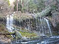
Contents

California Governor Arnold Schwarzenegger took President George H.W. Bush to see the falls. [3]

Description

Approximately 50 feet (15 m) in height and 175 feet (53 m) wide, the falls are fed by springs that course down the canyon wall, and into the Sacramento River, creating the effect of many waterfall streams, two of them especially large, falling into the river. The entire course of the falls is longer than 52 feet (16 m); however the upper cascades cannot be observed through flora that covers the mountainside. The bottom 50 feet (15 m) is a straight plunge into the river.

Etymology

The waterfall is named for the profusion of moss on the hillside at the site, together with brae, which means "a steep bank or hillside" in Irish and Scots.

Access

The trail to the falls from Dunsmuir requires trespassing beside the Union Pacific railroad tracks for 1.2 miles (1.9 km), before the waterfall appears on the right immediately before a railroad trestle that crosses the river. The railroad line runs in a cut and in places there is little space to avoid a train; two hikers were injured by trains in the second half of the 2010s. [3] The city of Dunsmuir closed the illegal parking area in the Shasta Retreat neighborhood in 2011, [4] and has since built most of an extension to the Hedge Creek Falls trail that when finished will cross the river on a pedestrian bridge 1,800 feet (550 m) from the falls, but requires Union Pacific's permission to complete it. [3]

Alternate means of access are through Mineral Spring Trail and Angel Trail in Shasta Springs, a private property owned by Saint Germain Foundation, and white water rafting from Box Canyon Dam.

Photos

Related Research Articles

<span class="mw-page-title-main">Sacramento River</span> River in Northern and Central California, United States

The Sacramento River is the principal river of Northern California in the United States and is the largest river in California. Rising in the Klamath Mountains, the river flows south for 400 miles (640 km) before reaching the Sacramento–San Joaquin River Delta and San Francisco Bay. The river drains about 26,500 square miles (69,000 km2) in 19 California counties, mostly within the fertile agricultural region bounded by the Coast Ranges and Sierra Nevada known as the Sacramento Valley, but also extending as far as the volcanic plateaus of Northeastern California. Historically, its watershed has reached as far north as south-central Oregon where the now, primarily, endorheic (closed) Goose Lake rarely experiences southerly outflow into the Pit River, the most northerly tributary of the Sacramento.

<span class="mw-page-title-main">Siskiyou County, California</span> County in California, United States

Siskiyou County is a county in the northernmost part of the U.S. state of California. As of the 2020 census, the population was 44,076. Its county seat is Yreka and its highest point is Mount Shasta. It falls within the Cascadia bioregion.

<span class="mw-page-title-main">Dunsmuir, California</span> City in the state of California, United States

Dunsmuir is a city in Siskiyou County, northern California. It is on the upper Sacramento River in the Trinity Mountains. Its population is 1,707 as of the 2020 census, up from 1,650 from the 2010 census.

<span class="mw-page-title-main">Mount Shasta, California</span> City in the state of California, United States

Mount Shasta is a city in Siskiyou County, California, at about 3,600 feet (1,100 m) above sea level on the flanks of Mount Shasta, a prominent northern California landmark. The city is less than 9 miles (14 km) southwest of the summit of its namesake volcano. Its population is 3,223 as of the 2020 census, down from 3,394 from the 2010 census.

<span class="mw-page-title-main">Multnomah Falls</span> Waterfall in Oregon, U.S.

Multnomah Falls is a waterfall located on Multnomah Creek in the Columbia River Gorge, east of Troutdale, between Corbett and Dodson, Oregon, United States. The waterfall is accessible from the Historic Columbia River Highway and Interstate 84. Spanning two tiers on basalt cliffs, it is the tallest waterfall in the state of Oregon at 620 ft (189 m) in height. The Multnomah Creek Bridge, built in 1914, crosses below the falls, and is listed on the National Register of Historic Places.

<span class="mw-page-title-main">Shasta Cascade</span> Mountainous region of California

The Shasta Cascade region of California is located in the northeastern and north-central sections of the state bordering Oregon and Nevada, including far northern parts of the Central Valley and the Sierra Nevada mountain range.

<span class="mw-page-title-main">McCloud River</span> River in California, United States

The McCloud River is a 77.1-mile (124.1 km) long river that flows east of and parallel to the upper Sacramento River, in Siskiyou County and Shasta County in northern California in the United States. Protected under California's Wild and Scenic Rivers Act (1972), it drains a scenic mountainous area of the Cascade Range, including part of Mount Shasta. It is a tributary of the Pit River, which in turn flows into the Sacramento River. The three rivers join in Shasta Lake, formed by Shasta Dam north of Redding.

<span class="mw-page-title-main">Upper Soda Springs</span>

Upper Soda Springs is on the banks of the Sacramento River in Dunsmuir, California, USA. It consists of approximately ten acres of level ground on both sides of the River, the surrounding hillsides, and continues north along the eastern bank of the Sacramento River to the Dunsmuir City Park. The State of California and the City of Dunsmuir are creating a new park on this historic site. The Upper Soda Springs site contains a riparian ecosystem and includes its namesake mineral water springs. In large part because of its location on the Siskiyou Trail, the site mirrors the history of the state and of the American West.

<span class="mw-page-title-main">Shasta Springs</span>

Shasta Springs was a popular summer resort during the late 19th and early 20th centuries on the Upper Sacramento River in northern California. It was located just north of the town of Dunsmuir, and just north of Upper Soda Springs along the Siskiyou Trail.

<span class="mw-page-title-main">Salmon River (Clackamas County, Oregon)</span> River in Oregon, United States

The Salmon River is a 33.5-mile (53.9 km) river in the Cascade Range in the U.S. state of Oregon that drains part of southwestern Mount Hood. The entire length of the river is a protected National Wild and Scenic River. Several portions are in protected wilderness. It is affluent to the Sandy River, a tributary of the Columbia River.

The Mud Creek Glacier is the southernmost glacier on Mount Shasta in the U.S. state of California. It lies to the east of Sargents Ridge on Shastarama point near 10,915 feet (3,327 m) above sea level. The glacier is smaller than the northern ones on Mount Shasta such as Whitney, Hotlum, Bolam, and Wintun Glaciers. There are approximately 80 glaciers in California and unlike the glaciers in Alaska, Colorado and Montana. California’s existing current glaciers are not remnants of the Pleistocene, but instead relatively young approximately 1,000 years in age. The Mud Creek Glacier is one of at least 7 recognized glaciers on Mt. Shasta by the United States Geological Survey (USGS) the rest being: Whitney, Hotlum, Bolam, Wintun, Konwakiton, and Watkins.

<span class="mw-page-title-main">Dunsmuir Botanical Gardens</span>

Dunsmuir City Park and Botanical Gardens is a 10-acre municipal park and botanical garden maintained by Dunsmuir Botanical Gardens Inc., a non-profit 501(c)(3)organization of volunteers within Dunsmuir City Park in the city of Dunsmuir, California near Mount Shasta. The Gardens are on City of Dunsmuir property under the general control of Siskiyou County via the Board of Directors of the Dunsmuir Park & Recreation District.

<i>Shasta Daylight</i>

The Shasta Daylight was a Southern Pacific Railroad passenger train between Oakland Pier in Oakland, California, and Portland, Oregon. It started on July 10, 1949, and was SP's third "Daylight" streamliner; it had a fast 15-hour-30-minute schedule in either direction for the 713-mile (1,147 km) trip through some of the most beautiful mountain scenery of any train in North America. The Shasta Daylight replaced heavyweight trains on the same route that had taken nearly a day and night to complete the run. The Shasta Daylight was the first diesel powered Daylight and the only Daylight to run beyond California. The scenic route of the Shasta Daylight passed its namesake Mount Shasta in daylight hours.

Castle Crags Wilderness Protected wilderness area in California, United States

The Castle Crags Wilderness is a 12,232-acre (49.50 km2) wilderness area in the Castle Crags rock formations of the Trinity Mountains, and within the Shasta-Trinity National Forest, in northwestern California. It is located in Siskiyou County and Shasta County, 40 miles (64 km) north of Redding and south of Mount Shasta City.

<span class="mw-page-title-main">Eagle Creek waterfalls</span>

Eagle Creek is a tributary of the Columbia River in Multnomah and Hood River counties in the U.S. state of Oregon. It cuts through a narrow canyon in its 3,200 feet (980 m) descent to the Columbia River Gorge and is known for its concentration of 13 waterfalls in about 5 miles (8.0 km) distance. Eight major falls are on Eagle Creek and the East Fork Eagle Creek itself, while five are on its tributaries.

<span class="mw-page-title-main">Salt Creek Falls</span> Waterfall in Lane County, Oregon

Salt Creek Falls is a cascade and plunge waterfall on Salt Creek, a tributary of the Middle Fork Willamette River, that plunges into a gaping canyon in the Willamette National Forest near Willamette Pass in Lane County, Oregon. The waterfall is notable for its main drop of 286 feet (87 m), ranking third highest among plunge waterfalls in Oregon, after Multnomah Falls and Watson Falls.) The pool at the bottom of Salt Creek Falls waterfall is 66 feet (20 m) deep.

<span class="mw-page-title-main">Havasu Creek</span> Stream in Arizona, United States of America

Havasu Creek is a stream in the U.S. state of Arizona associated with the Havasupai people. It is a tributary to the Colorado River, which it enters in the Grand Canyon.

<span class="mw-page-title-main">Pengra Pass rail route</span>

The Pengra Pass rail route, also known as the Natron Cutoff, the Cascade Subdivision, or the Cascade Line, is a Union Pacific Railroad line connecting Eugene, Oregon, with Klamath Falls, Oregon. Construction of the line began in 1905 and was completed in the mid-1920s. Its name denotes a mountain pass on the Lane County–Klamath County boundary in the Cascade Mountains of Oregon, about 1.5 miles (2.4 km) from Willamette Pass. The line heads southeast from Eugene, up the Cascades and over Pengra Pass, then southward beside U.S. Route 97 to Klamath Falls, where it splits in two, each track continuing into California. The route has at least 22 tunnels, several snow sheds and multiple bridges across canyons.

<span class="mw-page-title-main">Hedge Creek Falls</span>


Hedge Creek Falls is a waterfall on Hedge Creek, in the Shasta Cascade area in Dunsmuir, California. There is a small cave located behind the waterfall, allowing visitors to walk behind the cascading water. Shortly after the waterfall, hedge creek flows into the Sacramento River south of Mossbrae Falls. There is a viewing platform over the river, with a view of Mount Shasta. Access to the waterfall and viewing platform is via a short hiking trail. The trail starts at a small park off the Dunsmuir Ave/Siskiyou Ave exit on Interstate 5. The waterfall is 0.2 miles (0.32 km) down Hedge Creek Falls Trail. The close proximity to Interstate 5, makes the waterfall a very popular stopping point for passing motorists.

<span class="mw-page-title-main">Proxy Falls</span> Waterfall in Lane County, Oregon

Proxy Falls, also known as Lower Proxy Falls, is a cascade and plunge waterfall from a collection of springs on the shoulder of North Sister, that plunges into a gaping canyon near McKenzie Pass in the Willamette National Forest, near Belknap Springs, Oregon. The waterfall is notable for its main drop of 226 feet (69 m) which makes it one of the highest plunge waterfalls in Oregon.

References

  1. 1 2 "Mossbrae Falls". Geographic Names Information System . United States Geological Survey, United States Department of the Interior . Retrieved 2014-12-07.
  2. 1 2 3 4 5 "Mossbrae Falls". World Waterfall Database. Retrieved 2014-12-07.
  3. 1 2 3 Tom Stienstra (March 15, 2020). "Getting to Mossbrae Falls puts hikers at risk". San Francisco Chronicle. p. C15.
  4. Ryan Sabalow (August 11, 2011). "Visitors told to avoid Mossbrae Falls; Dunsmuir works on trail to attraction". The Redding Record Searchlight. Archived from the original on December 28, 2011.