
Mount Shasta is a potentially active stratovolcano at the southern end of the Cascade Range in Siskiyou County, California. At an elevation of 14,179 ft (4,322 m), it is the second-highest peak in the Cascades and the fifth-highest in the state. Mount Shasta has an estimated volume of 85 cubic miles, which makes it the most voluminous volcano in the Cascade Volcanic Arc. The mountain and surrounding area are part of the Shasta–Trinity National Forest.

Mount Bachelor, formerly named Bachelor Butte, is a dormant stratovolcano atop a shield volcano in the Cascade Volcanic Arc and the Cascade Range of central Oregon, United States. Named Mount Bachelor because it stands apart from the nearby Three Sisters, it lies in the eastern segment of the central portion of the High Cascades, the eastern segment of the Cascade Range. The volcano lies at the northern end of the 15-mile (24 km) long Mount Bachelor Volcanic Chain, which underwent four major eruptive episodes during the Pleistocene and the Holocene. The United States Geological Survey considers Mount Bachelor a moderate threat, but Bachelor poses little threat of becoming an active volcano in the near future. It remains unclear whether the volcano is extinct or just inactive.

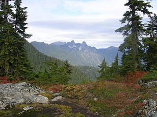
Mount Seymour is a mountain located in Mount Seymour Provincial Park in the District of North Vancouver, British Columbia, Canada. It is a part of the North Shore Mountains, rising to the north from the shores of Burrard Inlet and Indian Arm to a summit of 1,449 m (4,754 ft) above the Indian River and Deep Cove neighbourhoods. Mount Seymour is most commonly identified for its ski area of the same name, and as a popular hiking area. It is named in honour of Frederick Seymour, second governor of the Colony of British Columbia. The name is used to refer to the ridge although the main summit is one of several, and is also known as Third Peak.

Mount McLoughlin is a dormant steep-sided stratovolcano, or composite volcano, in the Cascade Range of southern Oregon and within the United States Sky Lakes Wilderness. It is one of the volcanic peaks in the Cascade Volcanic Arc, within the High Cascades sector. A prominent landmark for the Rogue River Valley, the mountain is north of Mount Shasta, and south-southwest of Crater Lake. It was named around 1838 after John McLoughlin, a Chief Factor for the Hudson's Bay Company. Mount McLouglin's prominence has made it a landmark to Native American populations for thousands of years.
Cypress Provincial Park is a provincial park on the North Shore of Metro Vancouver Regional District, British Columbia. The park has two sections: a 21 km2 (8.1 sq mi) southern section which is accessible by road from West Vancouver, and a 9 km2 (3.5 sq mi) northern section which is only accessible by hiking trails. The two sections are linked by a narrow strip of park along the mountainous Howe Sound Crest Trail.

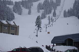
Cypress Mountain is a ski area in West Vancouver, British Columbia, Canada, located in the southern section of Cypress Provincial Park, operated under a BC Parks Park Use Permit.
Kratka Ridge or Snowcrest is a skiable area on Waterman Mountain in the San Gabriel Mountains of Los Angeles County, California. Located 36 miles northeast of La Cañada and Pasadena along the Angeles Crest Highway, it reaches a height of 7,515 feet.

Big White Ski Resort, simply known as Big White, is a ski resort located 56 km (35 mi) southeast of Kelowna in the Southern Interior of British Columbia. It is located on Big White Mountain, the highest summit in the Okanagan Highland, an upland area between the Monashee Mountains and the Okanagan Valley. Big White is the fourth largest resort in British Columbia, after Whistler-Blackcomb, Sun Peaks, and Silver Star. In 2019, Big White was nominated as the third-best ski resort in Canada by Snowpak.
Mount Bachelor ski resort is a ski resort located in Central Oregon, approximately 22 miles (35 km) west of Bend, along Century Drive Highway. The ski area is on the northern side of Mount Bachelor, a stratovolcano rising atop a volcanic shield in the Cascade Range.

Banff Sunshine Village is a ski resort in western Canada, located on the Continental Divide of the Canadian Rockies within Banff National Park in Alberta and Mount Assiniboine Provincial Park in British Columbia. It is one of three major ski resorts located in the Banff National Park. Because of its location straddling the Continental Divide, Sunshine receives more snow than the neighbouring ski resorts. The Sunshine base area is located 15 km (9 mi) southwest of the town of Banff. By car, it is about a ninety-minute drive from the city of Calgary; the Sunshine exit on the Trans Canada Highway is 8 km (5 mi) west of the town of Banff.

Copper Mountain is a mountain and ski resort located in Summit County, Colorado, about 75 miles (120 km) west of Denver on Interstate 70. The resort has 2,465 acres of in-bounds terrain under lease from the U.S. Forest Service, White River National Forest, Dillon Ranger District. It is operated by POWDR.
Hoodoo is a ski resort in the northwest United States, in the central Cascade Range of Oregon. Located near the summit of Santiam Pass on U.S. Route 20, the ski area operates on federal land through agreement with Willamette National Forest on Hoodoo Butte, a volcanic cinder cone. Hoodoo's slopes primarily face northeast.

The Magic Mile is an aerial chairlift at Timberline Lodge ski area, Mount Hood, Oregon, U.S. It was named for its unique location above the tree line and for its original length. When constructed by Byron Riblet in 1938, it was the longest chairlift in existence, the second in the world to be built as a passenger chairlift, and the first to use metal towers.

Timberline Lodge ski area is the ski and snowboarding area of Timberline Lodge, a National Historic Landmark in the U.S. state of Oregon. It is one of a few ski areas in the United States with most of the skiable terrain below the main lodge. It is located on the south face of Mount Hood, about 60 miles (95 km) east of Portland, accessible via the Mount Hood Scenic Byway.

Crystal Mountain is a mountain and alpine ski area in eastern Pierce County, Washington, United States, located in the Cascade Range southeast of Seattle. It is the largest ski resort in the state of Washington and lies within the Mount Baker–Snoqualmie National Forest. The resort is accessible from the Seattle–Tacoma metropolitan area via State Route 410.

The Summit at Snoqualmie is a recreation area in the northwest United States, located on Snoqualmie Pass, Washington. It provides alpine skiing and snowboarding, Nordic skiing, mountain biking, winter tubing, and scenic lift rides. Owned and managed by Boyne Resorts, it is 52 miles (80 km) east of downtown Seattle on Interstate 90.

Crested Butte Mountain Resort is a ski resort at Mount Crested Butte in Gunnison County, Colorado, United States.
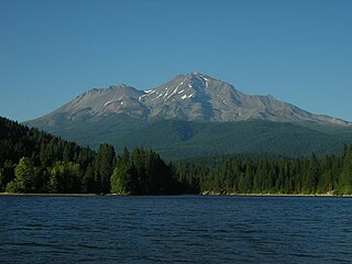
The Mount Shasta Wilderness is a 38,200-acre (155 km2) federally designated wilderness area located 5 miles (8.0 km) east of Mount Shasta City in northern California. The US Congress passed the 1984 California Wilderness Act that set aside the Mount Shasta Wilderness. The US Forest Service is the managing agency as the wilderness is within the Shasta-Trinity National Forest. The area is named for and is dominated by the Mount Shasta volcano which reaches a traditionally quoted height of 14,162 feet (4,317 m) above sea level, but official sources give values ranging from 14,104 feet (4,299 m) from one USGS project, to 14,179 feet (4,322 m) via the NOAA. Mount Shasta is one of only two peaks in the state over 14,000 feet (4,300 m) outside the Sierra Nevada Mountain Range. The other summit is White Mountain Peak in the Great Basin of east-central California.
Mount Sunapee Resort is a ski area and resort located in Mount Sunapee State Park in Newbury, New Hampshire, United States.


