
Nordic skiing encompasses the various types of skiing in which the toe of the ski boot is fixed to the binding in a manner that allows the heel to rise off the ski, unlike alpine skiing, where the boot is attached to the ski from toe to heel. Recreational disciplines include cross-country skiing and Telemark skiing.

A ski area is the terrain and supporting infrastructure where skiing and other snow sports take place. Such sports include alpine and cross-country skiing, snow boarding, tubing, sledding, etc. Ski areas may stand alone or be part of a ski resort.

Kananaskis Country is a multi-use area west of Calgary, Alberta, Canada in the foothills and front ranges of the Canadian Rockies. The area is named for the Kananaskis River, which was named by John Palliser in 1858 after a Cree acquaintance. Covering an area of approximately 4,000 km2 (1,500 sq mi), Kananaskis Country was formed by the Alberta Government in 1978 to provide an assortment of land uses and designations. Land uses include resource extraction activities, recreation, power generation, and residential communities. Land designations include public land and protected areas.
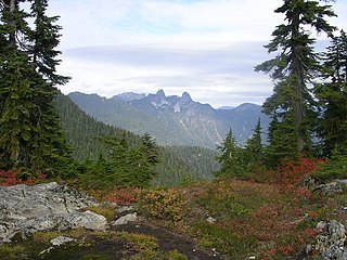
Cypress Provincial Park is a provincial park on the North Shore of Metro Vancouver Regional District, British Columbia. The park has two sections: a 21 km2 (8.1 sq mi) southern section which is accessible by road from West Vancouver, and a 9 km2 (3.5 sq mi) northern section which is only accessible by hiking trails. The two sections are linked by a narrow strip of park along the mountainous Howe Sound Crest Trail.

Ski touring is skiing in the backcountry on unmarked or unpatrolled areas. Touring is typically done off-piste and outside of ski resorts, and may extend over a period of more than one day. It is similar to backcountry skiing but excludes the use of a ski lift or transport.

Cypress Mountain is a ski area in West Vancouver, British Columbia, Canada, located in the southern section of Cypress Provincial Park, operated under a BC Parks Park Use Permit.

Mount Pinos is a mountain located in the Los Padres National Forest on the boundary between Ventura and Kern counties in California. The summit, at 8,847 feet (2,697 m), is the highest point in Ventura County. The mountain is the highest point of the Transverse Ranges west of Tejon Pass, as well as the southernmost point of the Salinian Block.

Badger Pass Ski Area is a small ski area located within Yosemite National Park. Badger Pass is one of only three lift serviced ski areas operating in a US National Park. It is situated five miles (8 km) south-southeast of the Chinquapin intersection of Wawona Road with Glacier Point Road in the southern area of Yosemite National Park. Glacier Point Road provides the access to this ski area. During high snow level and/or ski season, Glacier Point road terminates at Badger Pass Ski Resort. Under these conditions, the remainder of Glacier Point Road is used for cross-country skiing access to Glacier Point and other destinations in the high country.
Mount Grace State Forest is a publicly owned forest with recreational features located in the town of Warwick. The state forest centers around Mount Grace, which at 1,621 feet (494 m) is the third highest point in Massachusetts east of the Connecticut River after Mount Wachusett and Mount Watatic. It is bordered by portions of Warwick State Forest to the east and west and is managed by the Massachusetts Department of Conservation and Recreation.
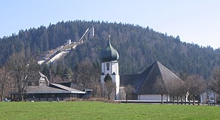
Hinterzarten is a resort village in the Black Forest, located in the southwest of the state of Baden-Württemberg, Germany. Although Hinterzarten is mostly famous for its ski jumping, it has many other tourist attractions.
Black Mountain of Maine is a ski resort in Rumford, Maine which is most famous for its Nordic skiing facilities, and has hosted several national cross-country skiing championships on its 17 km of trails.

Rukatunturi is a 490 metres (1,610 ft) high fell and a ski resort in Kuusamo, Finland. Apart from downhill skiing, there are over 500 km of cross-country skiing tracks. Also snowmobiles can be rented to enjoy some of the area's 600 km of snowmobile routes. Ruka is also the southern end of the Karhunkierros hiking trail. The total of trails in Ruka and Kuusamo area is: 160 km of hiking trails, 605 km of biking routes, 350 km of classified paddling routes and 100 km of boating routes.
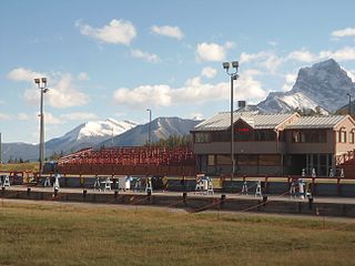
Canmore Nordic Centre Provincial Park is a provincial park in Alberta, Canada, located immediately west of Canmore, 105 km (65 mi) west of Calgary.

Burke Mountain is a mountain located in the Northeast Kingdom of Vermont. The bulk of the mountain is in Burke and Kirby, Caledonia County, but its southeast side is in Essex County. It is flanked to the east and southeast by Umpire Mountain and Kirby Mountain, respectively.
Bear Mountain Ski Hill is a ski area located on the outskirts of Dawson Creek, British Columbia, Canada. It was built in 1959 and has a T-Bar and ten runs. It is operated by the Bear Mountain Ski and Recreation Club. It is in the same vicinity as a large cross-country ski trail network operated by the Bear Mountain Nordic Ski Association.
Prospect mountain is a mountain located in the town of Woodford, Vermont in Bennington County, Vermont. The mountain is located in the southern region of Vermont's Green Mountains. It is home to the Prospect Mountain Nordic Ski Area, which has the highest base elevation of any ski area in New England, accounting for its abundance of natural snow. Prospect Mountain can be counted on to provide a long season for cross-country skiing.

The Tunxis Trail is a 79-mile (127 km) Blue-Blazed hiking trail "system" that traverses the western ridge of the central Connecticut Valley. The mainline trail is not completely contiguous, notably there are two gaps of several miles.
Joseph Peter "Joe Pete" Wilson was an American Olympic cross-country skier, who skied for the U.S. in cross-country at the 1960 Winter Olympics and later became a well-known skiing administrator in the United States. Wilson also in collaboration authored several books on cross-country skiing, all co-written by William J. Lederer. Wilson set up the cross-country ski area at the Trapp Family Lodge in Stowe, Vermont – the lodge established by the Trapp family of The Sound of Music fame. In 1973, Wilson organized a meeting of 25 ski areas and established the National Ski Touring Operators' Association. Wilson was named as its first President from 1973-1977. After several name changes it is now called the Cross Country Ski Areas Association (CCSAA). CCSAA is an international association of U.S. and Canadian cross-country ski areas. Wilson is also known for having set up an inn in Keene, New York, the Bark Eater Inn, and developing the ski trails around the inn.
Calvin Coolidge State Forest, also known as Coolidge State Forest, covers 22,564 acres (91.31 km2) in two parts in Rutland and Windsor counties in Vermont. The West portion cover 17,259 acres (69.84 km2) in Killington, Mendon, Plymouth and Shrewsbury in both counties. The East portion cover 5,305 acres (21.47 km2) in Bridgewater, Plymouth, Reading, and Woodstock in Windsor County.

Mount Mansfield State Forest covers 44,444 acres (179.86 km2) in seven towns in Chittenden, Lamoille and Washington counties in Vermont. The towns are Bolton and Underhill in Chittenden County, Cambridge, Johnson, Morristown and Stowe in Lamoille County, and Waterbury in Washington County. Mt. Mansfield State Forest is the largest contiguous landholding owned by the Vermont Department of Forests, Parks and Recreation.