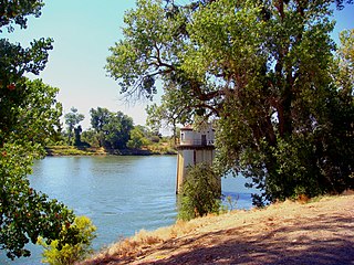
The Sacramento River is the principal river of Northern California in the United States and is the largest river in California. Rising in the Klamath Mountains, the river flows south for 400 miles (640 km) before reaching the Sacramento–San Joaquin River Delta and San Francisco Bay. The river drains about 26,500 square miles (69,000 km2) in 19 California counties, mostly within the fertile agricultural region bounded by the Coast Ranges and Sierra Nevada known as the Sacramento Valley, but also extending as far as the volcanic plateaus of Northeastern California. Historically, its watershed has reached as far north as south-central Oregon where the now, primarily, endorheic (closed) Goose Lake rarely experiences southerly outflow into the Pit River, the most northerly tributary of the Sacramento.

Klamath County was a county of California from 1851 to 1874. During its existence, the county seat moved twice and ultimately portions of the territory it once had were carved up and added to nearby counties. It was formed from the northwestern portion of Trinity County, and originally included all of the northwestern part of the state, from the Mad River in the south to Oregon in the north, from the Pacific Ocean in the west to the middle of what is now Siskiyou County in the east. It is the only county in California to be disestablished.

The Klamath Mountains are a rugged and lightly-populated mountain range in northwestern California and southwestern Oregon in the western United States. As a mountain system within both the greater Pacific Coast Ranges and the California Coast Ranges, the Klamath Mountains have a varied geology, with substantial areas of serpentinite and marble, and a climate characterized by moderately cold winters with very heavy snowfall and warm, very dry summers with limited rainfall, especially in the south. As a consequence of the geology and soil types, the mountains harbor several endemic or near-endemic trees, forming one of the largest collections of conifers in the world. The mountains are also home to a diverse array of fish and animal species, including black bears, large cats, owls, eagles, and several species of Pacific salmon. Millions of acres in the mountains are managed by the United States Forest Service. The northernmost and largest sub-range of the Klamath Mountains are the Siskiyou Mountains.
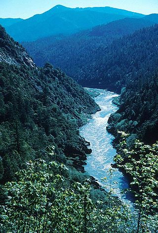
The Klamath River flows 257 miles (414 km) through Oregon and northern California in the United States, emptying into the Pacific Ocean. By average discharge, the Klamath is the second largest river in California after the Sacramento River. It drains an extensive watershed of almost 16,000 square miles (41,000 km2) that stretches from the arid country of south-central Oregon to the temperate rainforest of the Pacific coast. Unlike most rivers, the Klamath begins in the high desert and flows toward the mountains – carving its way through the rugged Cascade Range and Klamath Mountains before reaching the sea. The upper basin, today used for farming and ranching, once contained vast freshwater marshes that provided habitat for abundant wildlife, including millions of migratory birds. Most of the lower basin remains wild, with much of it designated wilderness. The watershed is known for this peculiar geography, and the Klamath has been called "a river upside down" by National Geographic magazine.

The Rogue River in southwestern Oregon in the United States flows about 215 miles (346 km) in a generally westward direction from the Cascade Range to the Pacific Ocean. Known for its salmon runs, whitewater rafting, and rugged scenery, it was one of the original eight rivers named in the Wild and Scenic Rivers Act of 1968. Beginning near Crater Lake, which occupies the caldera left by the explosive volcanic eruption and collapse of Mount Mazama, the river flows through the geologically young High Cascades and the older Western Cascades, another volcanic province. Further west, the river passes through multiple exotic terranes of the more ancient Klamath Mountains. In the Kalmiopsis Wilderness section of the Rogue basin are some of the world's best examples of rocks that form the Earth's mantle. Near the mouth of the river, the only dinosaur fragments ever discovered in Oregon were found in the Otter Point Formation, along the coast of Curry County.

The Chetco River is a 56-mile-long (90 km) stream located in the southwestern portion of the U.S. state of Oregon. It drains approximately 352 square miles (912 km2) of Curry County. Flowing through a rugged and isolated coastal region, it descends rapidly from about 3,200 feet (975 m) to sea level at the Pacific Ocean. Except for the lowermost 5 miles (8 km), the river is located entirely within the Rogue River – Siskiyou National Forest. The river rises in the Kalmiopsis Wilderness, northwest of Chetco Peak at the junction of the Oregon Coast Range and the Klamath Mountains. It flows generally north, west, and then southwest, before emptying into the ocean between Brookings and Harbor, approximately 6 miles (10 km) north of the California state line. The Chetco River's watershed remains largely undeveloped, protected by the Rogue River – Siskiyou National Forest and the Kalmiopsis Wilderness. The upper 45 miles (72 km) of the river have been designated Wild and Scenic since 1988.

The Trinity River is a major river in northwestern California in the United States and is the principal tributary of the Klamath River. The Trinity flows for 165 miles (266 km) through the Klamath Mountains and Coast Ranges, with a watershed area of nearly 3,000 square miles (7,800 km2) in Trinity and Humboldt Counties. Designated a National Wild and Scenic River, along most of its course the Trinity flows swiftly through tight canyons and mountain meadows.

The Siskiyou Mountains are a coastal subrange of the Klamath Mountains, and located in northwestern California and southwestern Oregon in the United States. They extend in an arc for approximately 100 miles (160 km) from east of Crescent City, California, northeast along the north side of the Klamath River into Josephine and Jackson counties in Oregon. The mountain range forms a barrier between the watersheds of the Klamath River to the south and the Rogue River to the north. Accordingly, much of the range is within the Rogue River – Siskiyou and Klamath national forests, and the Pacific Crest Trail follows a portion of the crest of the Siskiyous.
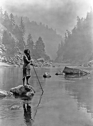
Hupa are a Native American people of the Athabaskan-speaking ethnolinguistic group in northwestern California. Their endonym is Natinixwe, also spelled Natinook-wa, meaning "People of the Place Where the Trails Return". The Karuk name was Kishákeevar / Kishakeevra. The majority of the tribe is enrolled in the federally recognized Hoopa Valley Tribe.
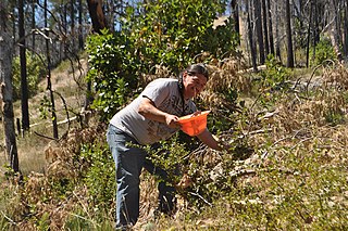
The Karuk people are an indigenous people of California, and the Karuk Tribe is one of the largest tribes in California. Karuks are also enrolled in two other federally recognized tribes, the Cher-Ae Heights Indian Community of the Trinidad Rancheria and the Quartz Valley Indian Community.
The Shastan peoples are a group of linguistically related indigenous peoples from the Klamath Mountains. They traditionally inhabited portions of several regional waterways including the Klamath, Salmon, Sacramento and McCloud rivers. Shastan lands presently form portions of the Siskiyou, Klamath and Jackson counties. Scholars have generally divided the Shastan peoples into four languages, although arguments in favor of more or less existing have been made. Speakers of Shasta proper-Kahosadi, Konomihu, Okwanuchu, and Tlohomtah’hello "New River" Shasta resided in settlements typically near a water source. Their villages often had only either one or two families. Larger villages had more families and additional buildings utilised by the community.
The Scott River is a 60-mile-long (97 km) river in Siskiyou County, California, United States. It is a tributary of the Klamath River, one of the largest rivers in California.
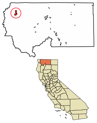
Happy Camp is a census-designated place (CDP) in Siskiyou County, California in the United States. Its population is 905 as of the 2020 census, down from 1,190 from the 2010 census.
Scott Valley is a large, scenic rural area of western Siskiyou County, California, known for its vistas of the Marble Mountains, cattle and dairy ranches, and its historic background as a gold mining area, dating back to the days of the California Gold Rush. The towns of Fort Jones, Etna, Greenview and Callahan are found within Scott Valley, as well as many other small villages.

The Little Applegate River is a 21-mile-long (34 km) tributary of the Applegate River located in the U.S. state of Oregon. It is part of the Rogue River watershed, draining approximately 113 square miles (293 km2) of Jackson County. Rising in the Siskiyou Mountains, the river flows generally northwest to meet the Applegate about 3 miles (4.8 km) northwest of Buncom and 2 miles (3.2 km) south of Ruch.

Sawyers Bar is an unincorporated community located on the North Fork Salmon River in unincorporated Siskiyou County, California, not to be confused with a Sawyers or Lawyers Bar in Del Norte County.
Black Bear is a populated place, originally a gold mining town in Klamath County, now in unincorporated Siskiyou County, California.
Gullion's Bar was a placer gold mining camp on the Salmon River, now located in Siskiyou County, California. It was located originally in Trinity County, in 1850.

Cottonwood Creek is a major stream and tributary of the Sacramento River in Northern California. About 68 miles (109 km) long measured to its uppermost tributaries, the creek drains a large rural area bounded by the crest of the Coast Ranges, traversing the northwestern Sacramento Valley before emptying into the Sacramento River near the town of Cottonwood. For its entire length, it defines the boundary of Shasta and Tehama counties. Because Cottonwood Creek is the largest undammed tributary of the Sacramento River, it is known for its Chinook salmon and steelhead runs.

The McKinney Fire was a destructive wildfire in the Klamath National Forest in western Siskiyou County during the 2022 California wildfire season. The fire was named for its ignition point near McKinney Creek Road, where the fire began on July 29, 2022, at approximately 2:15 p.m. PDT. The McKinney Fire experienced explosive weather-driven growth over the next day and a half, consuming more than 50,000 acres in less than 36 hours, destroying at least 185 structures and causing 4 fatalities.


