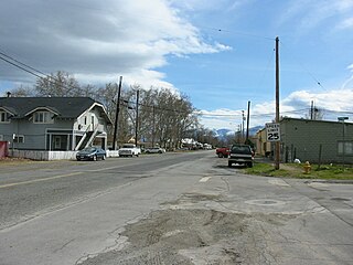
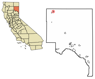
Forks of Salmon is an unincorporated community of Siskiyou County in northern California, USA. The town is situated at the confluence of the north and south forks of the Salmon River, hence its name. The ZIP Code is 96031. The community is inside area code 530.
Forks of Salmon was originally a California Gold Rush settlement in the now defunct Klamath County, California. It has had its own post office from September 30, 1858, until today, with a short break from October 16, 1871, to August 28, 1872. [1]
In the state legislature, Forks of Salmon is in the 1st Senate District , represented by Republican Brian Dahle, [2] and the 1st Assembly District , represented by Republican Megan Dahle. [3]
Federally, Forks of Salmon is in California's 1st congressional district , represented by Republican Doug LaMalfa. [4]

Alturas is the county seat of Modoc County, California. Alturas is still referred to as Kasalektawi by the indigenous Achomawi. The population of Alturas was 2,827 at the 2010 census.

Beckwourth is a census-designated place (CDP) in Plumas County, California, United States. Beckwourth is located on the Middle Fork Feather River 5 miles (8.0 km) east of Portola. The population was 432 at the 2010 census, up from 342 at the 2000 census.

Belden is a census-designated place (CDP) in Plumas County, California, United States. Belden is located on the North Fork Feather River, 7 miles (11.3 km) southwest of Caribou. The population was 22 at the 2010 census, down from 26 in 2000.

Clio is a census-designated place in Plumas County, California, United States. Clio is located 23 miles (37.0 km) southeast of Quincy. The population was 66 at the 2010 census, down from 90 at the 2000 census.

Cromberg is a census-designated place (CDP) in Plumas County, California, United States. Cromberg is located on the Western Pacific Railroad, 6.5 miles (10.5 km) northwest of Blairsden. The population was 261 at the 2010 census, down from 290 at the 2000 census.
Grenada is a census-designated place (CDP) in Siskiyou County, California, United States. The population was 367 at the 2010 census, up from 351 at the 2000 census. The ZIP code is 96038 and the community is within area code 530.

Washington is a census-designated place located in Nevada County, California. Washington is located on the banks of the South Fork of The Yuba River and has a population of approximately two hundred people. There is a hotel/bar and restaurant, grocery store, a one-room schoolhouse that has educated students continuously for one hundred years, and two trailer park campgrounds. The elevation is 2,612 feet (796 m). The population was 185 at the 2010 census.
Bieber is a census-designated place (CDP) in Lassen County, California. It is located on the Pit River 55 miles (89 km) north-northwest of Susanville, at an elevation of 4124 feet. Its population was 312 at the 2010 census. The ZIP Code is 96009. The community is inside area code 530.
Fort Bidwell is a census-designated place in Modoc County, California. It is located 32 miles (51 km) northeast of Alturas, at an elevation of 4564 feet. The population was 173 at the 2010 census.

Janesville is a census-designated place in Lassen County, California. It is located 11 miles (18 km) southeast of Susanville, at an elevation of 4239 feet. Janesville is located on the eastern slopes of the Sierra Nevada Mountain range. As of the 2010 census, it had a population of 1,408.

El Dorado, not to be confused with the nearby El Dorado Hills, is an unincorporated community in El Dorado County, California. It is located 4 miles (6.4 km) southwest of Placerville, at an elevation of 1608 feet. The population was 4,096 at the 2000 census. The town is registered as California Historical Landmark #486. The ZIP code is 95623. The community is inside area code 530.

Newell is a census-designated place in Modoc County, California in the United States. It is located 50 miles (80 km) west-northwest of Alturas, at an elevation of 4,042 feet (1,232 m). The population was 449 at the 2010 census.
Igo is an unincorporated community with 625 residents 9 miles west of Redding, CA. Its ZIP Code is 96047. Wired Telephone numbers follow the pattern 530-396-xxxx. It has a neighboring town of Ono, which is four miles west of Igo. It is also home to the Northern California Veterans Cemetery, dedicated in December 2005. It has a post office, elementary school, general store, and a restaurant/beer & wine bar/banquet hall - The Igo Inn. It is also home to Brigadoon Castle Bed and Breakfast, but it is now a private residence.

Orleans, is an unincorporated community in Humboldt County, California. It is located 12 miles (19 km) northeast of Weitchpec along State Route 96, at an elevation of 404 feet. The ZIP Code is 95556. It is within the area code 530. It is within the aboriginal territory of the Karuk Tribe of California.

Whitethorn is an unincorporated community in Humboldt County, California. It is located 9.5 miles southwest of Garberville, at an elevation of 1,024 feet, with a population of 817. Whitethorn shares a ZIP Code, 95589, with Shelter Cove, California. It is located along California's Lost Coast.
Oak Run is a small unincorporated community 23 miles (37 km) east of Redding in Shasta County, California, United States. The towns of Bella Vista, Millville, Shingletown, Palo Cedro, Whitmore, and Round Mountain lie within a 15 miles (24 km) radius. It has a store and a post office run by a family who lives in the town-famous "Oak Run House", just behind the store and post office. It also has a school, library, a volunteer fire department and 765 people. The ZIP Code is 96069. The community is inside area code 530.

Castella is a small, unincorporated community of 240 in the upper Sacramento Canyon of Shasta County, California. It is located 46 miles north of Redding on Interstate 5, and is home to Castle Crags State Park. It has a Chevron gas station/store and a post office. The ZIP Code is 96017. The community is inside area code 530.
Eagleville is a census-designated place in Modoc County, California. It is located 25 miles (40 km) east-southeast of Alturas, at an elevation of 4642 feet. The population was 59 at the 2010 census.
Likely is a census-designated place in Modoc County, California. It is located near the South Fork of the Pit River 18 miles (29 km) south of the county seat of Alturas, at an elevation of 4,449 feet (1,356 m). Located 6 miles (9.7 km) north-northwest of Likely Mountain, it is somewhat sheltered from prevailing southwesterly winds, and its microclimate is noticeably drier and less stormy than surrounding areas. The ZIP Code for the community is 96116.
Floriston is an unincorporated community and census-designated place in Nevada County, California. It is situated at an elevation of 5,400 ft (1,600 m) above sea level. Floriston is located on the Truckee River, 10 miles (16.1 km) east-northeast of Truckee. Formerly an important railroad stop and mill town, Floriston survives to this day as a small residential community. The population was 73 at the 2010 census.
Coordinates: 41°15′30″N123°19′18″W / 41.25833°N 123.32167°W
Municipalities and communities of Siskiyou County, California, United States | ||
|---|---|---|
| Cities |  | |
| CDPs | ||
| Unincorporated communities | ||
| Indian reservation | ||
| Ghost towns | ||
| Footnotes | ‡This populated place also has portions in an adjacent county or counties | |
| | This Siskiyou County, California-related article is a stub. You can help Wikipedia by expanding it. |